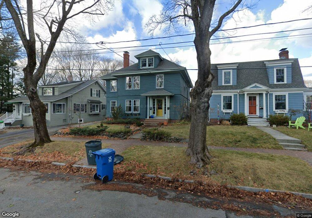
69 Woodmont St Portland, ME 04102
Oakdale NeighborhoodEstimated Value: $705,000 - $816,690
4
Beds
2
Baths
2,284
Sq Ft
$329/Sq Ft
Est. Value
About This Home
This home is located at 69 Woodmont St, Portland, ME 04102 and is currently estimated at $751,173, approximately $328 per square foot. 69 Woodmont St is a home located in Cumberland County with nearby schools including Ocean Avenue Elementary School, King Middle School, and Baxter Academy for Tech & Sciences.
Ownership History
Date
Name
Owned For
Owner Type
Purchase Details
Closed on
Nov 23, 2016
Sold by
Strods Anita M and Dore David P
Bought by
Dore Anita S and Dore David P
Current Estimated Value
Purchase Details
Closed on
Apr 27, 2007
Sold by
Duffy William J and Duffy Kristin C
Bought by
Strods Anita M and Dore David P
Home Financials for this Owner
Home Financials are based on the most recent Mortgage that was taken out on this home.
Original Mortgage
$284,000
Outstanding Balance
$172,843
Interest Rate
6.18%
Mortgage Type
Unknown
Estimated Equity
$578,330
Create a Home Valuation Report for This Property
The Home Valuation Report is an in-depth analysis detailing your home's value as well as a comparison with similar homes in the area
Home Values in the Area
Average Home Value in this Area
Purchase History
| Date | Buyer | Sale Price | Title Company |
|---|---|---|---|
| Dore Anita S | -- | -- | |
| Strods Anita M | -- | -- |
Source: Public Records
Mortgage History
| Date | Status | Borrower | Loan Amount |
|---|---|---|---|
| Open | Strods Anita M | $284,000 | |
| Closed | Strods Anita M | $53,250 |
Source: Public Records
Tax History Compared to Growth
Tax History
| Year | Tax Paid | Tax Assessment Tax Assessment Total Assessment is a certain percentage of the fair market value that is determined by local assessors to be the total taxable value of land and additions on the property. | Land | Improvement |
|---|---|---|---|---|
| 2024 | $8,189 | $545,600 | $91,300 | $454,300 |
| 2023 | $7,862 | $545,600 | $91,300 | $454,300 |
| 2022 | $7,426 | $545,600 | $91,300 | $454,300 |
| 2021 | $7,087 | $545,600 | $91,300 | $454,300 |
| 2020 | $6,492 | $278,500 | $85,800 | $192,700 |
| 2019 | $6,492 | $278,500 | $85,800 | $192,700 |
| 2018 | $6,261 | $278,500 | $85,800 | $192,700 |
| 2017 | $6,030 | $278,500 | $85,800 | $192,700 |
| 2016 | $5,879 | $278,500 | $85,800 | $192,700 |
| 2015 | $5,745 | $278,500 | $85,800 | $192,700 |
| 2014 | $5,570 | $278,500 | $85,800 | $192,700 |
Source: Public Records
Map
Nearby Homes
- 61 Deane St
- 55 Payson St Unit 2
- 200 Massachusetts Ave
- 232 Brighton Ave
- 296 Brighton Ave
- 14 Prospect St
- 7 Cherry St
- 48 Ashmont St
- 6 Highland St
- 24 Edwards St
- 160 Craigie St
- 14 Boynton St
- 103 Deerfield Rd
- 867 Congress St
- 14 Baxter Blvd
- 242 Valley St
- 34 Deering Ave
- 807 Congress St
- 65 Dougherty Ct Unit 203
- 65 Dougherty Ct Unit 104
- 67 Woodmont St
- 75 Woodmont St
- 62 Kenwood St
- 58 Kenwood St
- 63 Woodmont St
- 54 Kenwood St
- 495 St John St
- 59 Woodmont St
- 68 Woodmont St
- 74 Woodmont St
- 55 Woodmont St
- 493 Saint John St
- 497 Saint John St
- 495 Saint John St
- 493 St John St
- 66 Woodmont St
- 78 Woodmont St
- 48 Kenwood St
- 62 Woodmont St
- 505 Saint John St