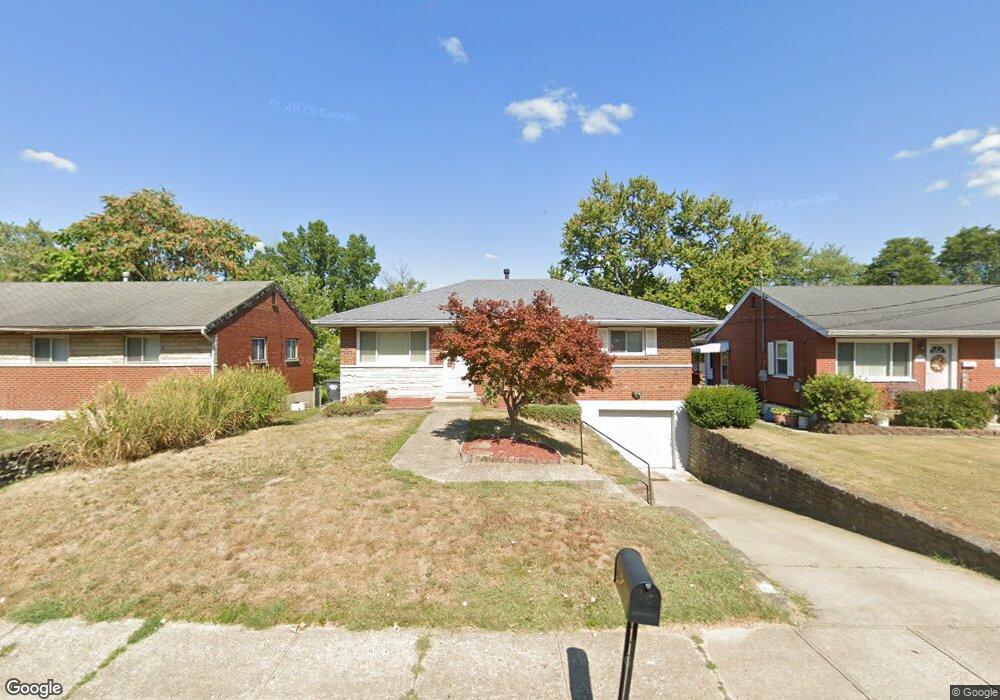
690 Maple Tree Ln Erlanger, KY 41018
Estimated Value: $219,000 - $233,642
3
Beds
2
Baths
988
Sq Ft
$232/Sq Ft
Est. Value
About This Home
This home is located at 690 Maple Tree Ln, Erlanger, KY 41018 and is currently estimated at $228,911, approximately $231 per square foot. 690 Maple Tree Ln is a home located in Boone County with nearby schools including Florence Elementary School, Jones Middle School, and Boone County High School.
Ownership History
Date
Name
Owned For
Owner Type
Purchase Details
Closed on
Aug 26, 2022
Sold by
Tunstall William
Bought by
Tunstall Family Revocable Trust
Current Estimated Value
Purchase Details
Closed on
Dec 4, 2002
Sold by
Faris James L
Bought by
Tunstall William R and Tunstall Mindy
Home Financials for this Owner
Home Financials are based on the most recent Mortgage that was taken out on this home.
Original Mortgage
$89,010
Interest Rate
6.3%
Mortgage Type
New Conventional
Create a Home Valuation Report for This Property
The Home Valuation Report is an in-depth analysis detailing your home's value as well as a comparison with similar homes in the area
Home Values in the Area
Average Home Value in this Area
Purchase History
| Date | Buyer | Sale Price | Title Company |
|---|---|---|---|
| Tunstall Family Revocable Trust | -- | -- | |
| Tunstall William R | $98,900 | -- |
Source: Public Records
Mortgage History
| Date | Status | Borrower | Loan Amount |
|---|---|---|---|
| Previous Owner | Tunstall William R | $89,010 |
Source: Public Records
Tax History Compared to Growth
Tax History
| Year | Tax Paid | Tax Assessment Tax Assessment Total Assessment is a certain percentage of the fair market value that is determined by local assessors to be the total taxable value of land and additions on the property. | Land | Improvement |
|---|---|---|---|---|
| 2025 | $1,624 | $138,000 | $20,000 | $118,000 |
| 2024 | $1,598 | $138,000 | $20,000 | $118,000 |
| 2023 | $1,652 | $138,000 | $20,000 | $118,000 |
| 2022 | $1,584 | $138,000 | $20,000 | $118,000 |
| 2021 | $1,662 | $138,000 | $20,000 | $118,000 |
| 2020 | $1,225 | $104,730 | $15,000 | $89,730 |
| 2019 | $1,208 | $104,730 | $15,000 | $89,730 |
| 2018 | $1,265 | $104,730 | $15,000 | $89,730 |
| 2017 | $1,197 | $104,730 | $15,000 | $89,730 |
| 2015 | $1,189 | $104,730 | $15,000 | $89,730 |
| 2013 | -- | $104,730 | $15,000 | $89,730 |
Source: Public Records
Map
Nearby Homes
- 3395 Cedar Tree Ln
- 3375 Fir Tree Ln
- 3815 Hope Ln
- 3213 Riggs Ave
- 437 Center St
- 3915 Rankin Dr
- 419 Locust St
- 6609 Highridge Ave
- 3169 Birch Dr
- 403 Locust St
- 6050 Belair Dr
- 126 Clay St
- 122 Clay St
- 304 Forest Ave
- 424 Kentaboo Ave
- 135 Dale Hollow Dr Unit 11
- 2474 Sierra Dr
- 165 Barren River Dr Unit 8
- 4016 Dixie Hwy
- Carrington Plan at Reserve at Meadowood - Designer Collection
- 692 Maple Tree Ln
- 688 Maple Tree Ln
- 686 Maple Tree Ln
- 694 Maple Tree Ln
- 684 Maple Tree Ln
- 3429 Maple Tree Ln
- 3427 Maple Tree Ln
- 687 Peach Tree Ln
- 685 Peach Tree Ln
- 689 Peach Tree Ln
- 683 Peach Tree Ln
- 691 Peach Tree Ln
- 693 Maple Tree Ln
- 689 Maple Tree Ln
- 3425 Maple Tree Ln
- 681 Peach Tree Ln
- 687 Maple Tree Ln
- 680 Maple Tree Ln
- 697 Maple Tree Ln
- 685 Maple Tree Ln