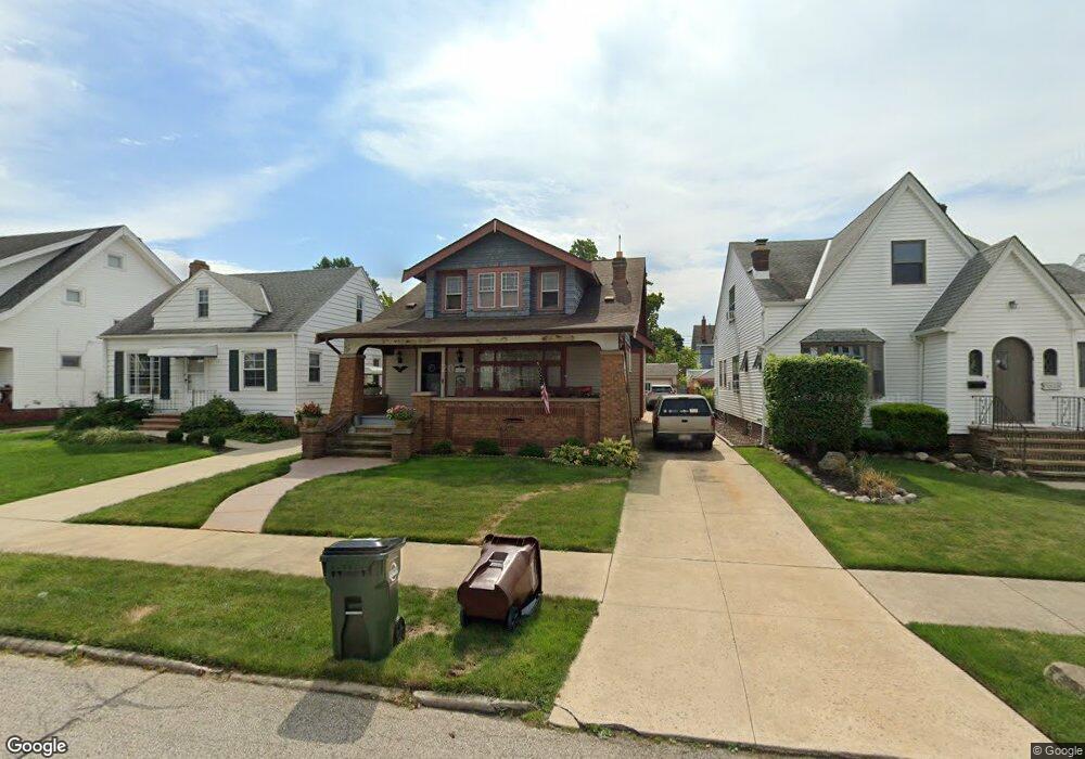
6915 Thornton Dr Cleveland, OH 44129
Estimated Value: $188,773 - $273,000
4
Beds
1
Bath
1,657
Sq Ft
$134/Sq Ft
Est. Value
About This Home
This home is located at 6915 Thornton Dr, Cleveland, OH 44129 and is currently estimated at $222,443, approximately $134 per square foot. 6915 Thornton Dr is a home located in Cuyahoga County with nearby schools including Renwood Elementary School, Thoreau Park Elementary School, and Shiloh Middle School.
Ownership History
Date
Name
Owned For
Owner Type
Purchase Details
Closed on
Jul 14, 2016
Sold by
Estate Of Cynthia M Koehler
Bought by
Koehler Andrew
Current Estimated Value
Purchase Details
Closed on
Jun 18, 1998
Sold by
Estate Of Constance Koeler
Bought by
Koehler Cynthia
Purchase Details
Closed on
Jul 19, 1984
Sold by
Szegda Alex
Bought by
Koeller Constance
Purchase Details
Closed on
Jan 1, 1975
Bought by
Szegda Alex
Create a Home Valuation Report for This Property
The Home Valuation Report is an in-depth analysis detailing your home's value as well as a comparison with similar homes in the area
Home Values in the Area
Average Home Value in this Area
Purchase History
| Date | Buyer | Sale Price | Title Company |
|---|---|---|---|
| Koehler Andrew | -- | None Available | |
| Koehler Cynthia | -- | -- | |
| Koeller Constance | -- | -- | |
| Szegda Alex | -- | -- |
Source: Public Records
Tax History Compared to Growth
Tax History
| Year | Tax Paid | Tax Assessment Tax Assessment Total Assessment is a certain percentage of the fair market value that is determined by local assessors to be the total taxable value of land and additions on the property. | Land | Improvement |
|---|---|---|---|---|
| 2024 | $3,092 | $50,085 | $10,570 | $39,515 |
| 2023 | $2,900 | $40,570 | $9,350 | $31,220 |
| 2022 | $2,872 | $40,570 | $9,350 | $31,220 |
| 2021 | $2,953 | $40,570 | $9,350 | $31,220 |
| 2020 | $2,586 | $31,190 | $7,180 | $24,010 |
| 2019 | $2,474 | $89,100 | $20,500 | $68,600 |
| 2018 | $2,377 | $31,190 | $7,180 | $24,010 |
| 2017 | $2,427 | $28,390 | $5,570 | $22,820 |
| 2016 | $2,412 | $28,390 | $5,570 | $22,820 |
| 2015 | $2,264 | $28,390 | $5,570 | $22,820 |
| 2014 | $2,302 | $28,980 | $5,670 | $23,310 |
Source: Public Records
Map
Nearby Homes
- 7014 Thornton Dr
- 6708 Thornton Dr
- 7115 Hampstead Ave
- 6096 Wareham Dr
- 6818 Hampstead Ave
- 6111 Manchester Rd
- 6610 Renwood Dr
- 6143 Wareham Dr
- 6704 Charles Ave
- 6136 Ridge Rd
- 7514 Spring Garden Rd
- 7706 Renwood Dr
- 6903 Alber Ave
- 7615 Bertha Ave
- 6706 Alber Ave
- 6406 Sunderland Dr
- 6227 Ridge Rd
- 6234 N Canterbury Rd
- 5815 Wilber Ave
- 6506 Snow Rd
- 6911 Thornton Dr
- 7003 Thornton Dr
- 6907 Thornton Dr
- 7007 Thornton Dr
- 6903 Thornton Dr
- 7011 Thornton Dr
- 7002 Brownfield Dr
- 7006 Brownfield Dr
- 6914 Brownfield Dr
- 7010 Brownfield Dr
- 6819 Thornton Dr
- 7015 Thornton Dr
- 6910 Thornton Dr
- 6914 Thornton Dr
- 6906 Brownfield Dr
- 7014 Brownfield Dr
- 6906 Thornton Dr
- 7002 Thornton Dr
- 6815 Thornton Dr
- 7103 Thornton Dr