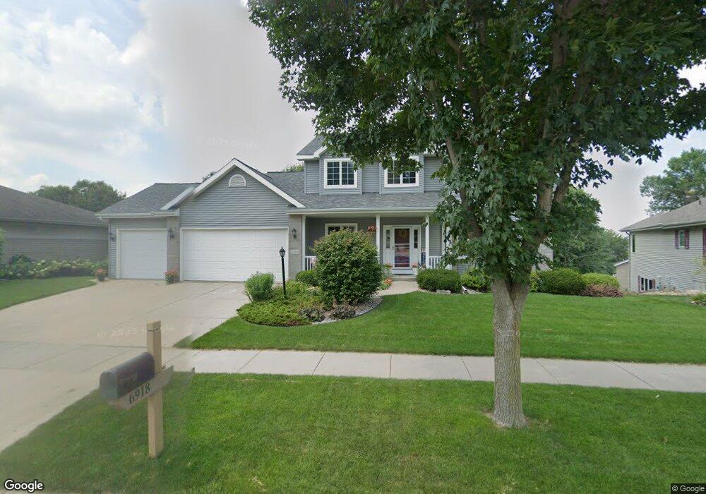
6918 Bluff Point Dr Madison, WI 53718
East Madison NeighborhoodEstimated Value: $536,000 - $617,000
4
Beds
4
Baths
2,467
Sq Ft
$233/Sq Ft
Est. Value
About This Home
This home is located at 6918 Bluff Point Dr, Madison, WI 53718 and is currently estimated at $573,961, approximately $232 per square foot. 6918 Bluff Point Dr is a home located in Dane County with nearby schools including Kennedy Elementary School, Whitehorse Middle School, and La Follette High School.
Ownership History
Date
Name
Owned For
Owner Type
Purchase Details
Closed on
Jun 15, 2007
Sold by
Olson Bradley E and Olson Debra L
Bought by
Hellrood Robin L and Hellrood Michelle L
Current Estimated Value
Home Financials for this Owner
Home Financials are based on the most recent Mortgage that was taken out on this home.
Original Mortgage
$280,000
Outstanding Balance
$172,994
Interest Rate
6.37%
Mortgage Type
Purchase Money Mortgage
Estimated Equity
$400,967
Create a Home Valuation Report for This Property
The Home Valuation Report is an in-depth analysis detailing your home's value as well as a comparison with similar homes in the area
Home Values in the Area
Average Home Value in this Area
Purchase History
| Date | Buyer | Sale Price | Title Company |
|---|---|---|---|
| Hellrood Robin L | $350,000 | None Available |
Source: Public Records
Mortgage History
| Date | Status | Borrower | Loan Amount |
|---|---|---|---|
| Open | Hellrood Robin L | $280,000 |
Source: Public Records
Tax History
| Year | Tax Paid | Tax Assessment Tax Assessment Total Assessment is a certain percentage of the fair market value that is determined by local assessors to be the total taxable value of land and additions on the property. | Land | Improvement |
|---|---|---|---|---|
| 2024 | $18,156 | $532,700 | $112,300 | $420,400 |
| 2023 | $8,769 | $502,500 | $105,900 | $396,600 |
| 2022 | $17,377 | $456,800 | $109,400 | $347,400 |
| 2021 | $9,277 | $449,600 | $96,000 | $353,600 |
| 2020 | $9,348 | $428,200 | $91,400 | $336,800 |
| 2019 | $9,079 | $415,700 | $88,700 | $327,000 |
| 2018 | $8,650 | $395,900 | $88,700 | $307,200 |
| 2017 | $8,496 | $373,500 | $88,700 | $284,800 |
| 2016 | $8,297 | $355,700 | $88,700 | $267,000 |
| 2015 | $7,999 | $338,800 | $84,500 | $254,300 |
| 2014 | $7,999 | $338,800 | $84,500 | $254,300 |
| 2013 | $7,029 | $303,400 | $83,600 | $219,800 |
Source: Public Records
Map
Nearby Homes
- 302 E Hill Pkwy
- Lot 4 Wyalusing Dr
- Lot 2 Wyalusing Dr
- Lot 3 Wyalusing Dr
- Lot 5 Wyalusing Dr
- Lot 1 Wyalusing Dr
- 6915 Dominion Dr
- 220 Red Birch Run
- 6725 Reston Heights Dr Unit 3
- 7109 Reston Heights Dr
- 7115 Reston Heights Dr
- 704 Herndon Dr Unit 201
- 3058 County Highway Bb -
- 607 Malvern Hill Dr
- 705 Malvern Hill Dr
- 6418 Driscoll Dr
- 6402 Milwaukee St Unit 107
- 6402 Milwaukee St Unit 307
- 101 Metro Terrace Unit 102
- 101 Metro Terrace Unit 303
- 7002 Bluff Point Dr
- 6914 Bluff Point Dr
- 405 Bailey Dr
- 6901 Stockbridge Dr
- 409 Bailey Dr
- 6905 Stockbridge Dr
- 7006 Bluff Point Dr
- 6910 Bluff Point Dr
- 6917 Bluff Point Dr
- 7001 Bluff Point Dr
- 6913 Bluff Point Dr
- 6909 Stockbridge Dr
- 413 Bailey Dr
- 6906 Bluff Point Dr
- 6909 Bluff Point Dr
- 7018 Bluff Point Dr
- 7009 Bluff Point Dr
- 402 Bailey Dr
- 6913 Stockbridge Dr
- 406 Bailey Dr
Your Personal Tour Guide
Ask me questions while you tour the home.