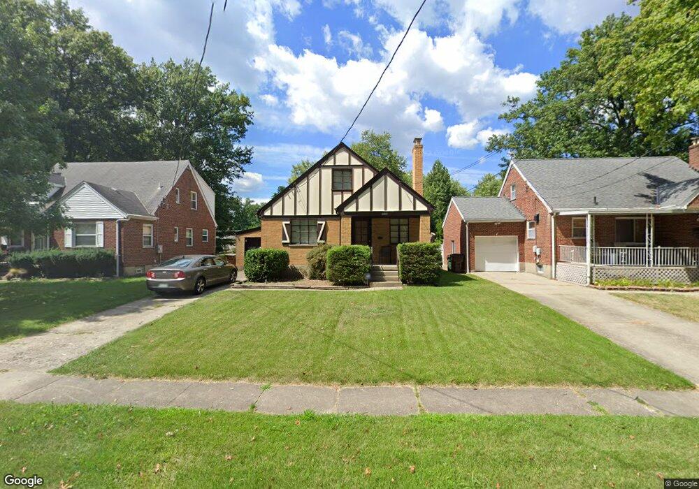
6921 Rob Vern Dr Cincinnati, OH 45239
Estimated Value: $184,000 - $216,000
4
Beds
1
Bath
1,732
Sq Ft
$118/Sq Ft
Est. Value
About This Home
This home is located at 6921 Rob Vern Dr, Cincinnati, OH 45239 and is currently estimated at $203,785, approximately $117 per square foot. 6921 Rob Vern Dr is a home located in Hamilton County with nearby schools including North College Hill Elementary School, North College Hill Middle School, and North College Hill High School.
Ownership History
Date
Name
Owned For
Owner Type
Purchase Details
Closed on
Jul 27, 2010
Sold by
Pelzel Michael J and Pelzel Nancy L
Bought by
Fox Felicia A
Current Estimated Value
Home Financials for this Owner
Home Financials are based on the most recent Mortgage that was taken out on this home.
Original Mortgage
$88,310
Outstanding Balance
$60,440
Interest Rate
5.25%
Mortgage Type
FHA
Estimated Equity
$143,345
Purchase Details
Closed on
Mar 10, 1997
Sold by
Pelzel Patricia A
Bought by
Pelzel Charles J and Pelzel Patricia A
Create a Home Valuation Report for This Property
The Home Valuation Report is an in-depth analysis detailing your home's value as well as a comparison with similar homes in the area
Home Values in the Area
Average Home Value in this Area
Purchase History
| Date | Buyer | Sale Price | Title Company |
|---|---|---|---|
| Fox Felicia A | $89,500 | Arrow Title Agency | |
| Pelzel Charles J | -- | -- |
Source: Public Records
Mortgage History
| Date | Status | Borrower | Loan Amount |
|---|---|---|---|
| Open | Fox Felicia A | $88,310 |
Source: Public Records
Tax History Compared to Growth
Tax History
| Year | Tax Paid | Tax Assessment Tax Assessment Total Assessment is a certain percentage of the fair market value that is determined by local assessors to be the total taxable value of land and additions on the property. | Land | Improvement |
|---|---|---|---|---|
| 2024 | $2,667 | $52,721 | $6,759 | $45,962 |
| 2023 | $2,691 | $52,721 | $6,759 | $45,962 |
| 2022 | $2,387 | $33,380 | $5,530 | $27,850 |
| 2021 | $2,336 | $33,380 | $5,530 | $27,850 |
| 2020 | $2,049 | $33,380 | $5,530 | $27,850 |
| 2019 | $2,010 | $29,281 | $4,851 | $24,430 |
| 2018 | $2,011 | $29,281 | $4,851 | $24,430 |
| 2017 | $1,902 | $29,281 | $4,851 | $24,430 |
| 2016 | $1,800 | $29,446 | $7,004 | $22,442 |
| 2015 | $1,804 | $29,446 | $7,004 | $22,442 |
| 2014 | $1,802 | $29,446 | $7,004 | $22,442 |
| 2013 | $1,859 | $31,326 | $7,452 | $23,874 |
Source: Public Records
Map
Nearby Homes
- 2943 Pin Oak Dr
- 2927 Pin Oak Dr
- 6942 Gloria Dr
- 6909 Lois Dr
- 6941 Mulberry St
- 6943 Mulberry St
- 7004 Mulberry St
- 2029 Sundale Ave
- 6912 Noble Ave
- 7068 Mulberry St
- 2347 Golf Dr
- 1944 Dallas Ave
- 2390 Golf Dr
- 1850 Bising Ave
- 8515 Pollux Ct
- 1841 Bising Ave
- 1842 Bising Ave
- 1917 Dallas Ave
- 2378 Bluelark Dr
- 8729 Morningstar Ln
- 6919 Rob Vern Dr
- 6923 Rob Vern Dr
- 6919 Ron Vern Dr
- 6917 Rob Vern Dr
- 6925 Rob Vern Dr
- 6927 Rob Vern Dr
- 6915 Rob Vern Dr
- 6920 Rob Vern Dr
- 6922 Rob Vern Dr
- 6913 Rob Vern Dr
- 6929 Rob Vern Dr
- 6918 Rob Vern Dr
- 6924 Rob Vern Dr
- 6916 Rob Vern Dr
- 6926 Rob Vern Dr
- 6914 Rob Vern Dr
- 6911 Rob Vern Dr
- 6931 Rob Vern Dr
- 6922 Dianna Dr
- 6920 Dianna Dr