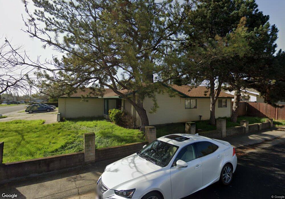
6921 Sandrock Way Sacramento, CA 95828
Estimated Value: $336,000 - $441,000
3
Beds
2
Baths
1,379
Sq Ft
$288/Sq Ft
Est. Value
About This Home
This home is located at 6921 Sandrock Way, Sacramento, CA 95828 and is currently estimated at $396,870, approximately $287 per square foot. 6921 Sandrock Way is a home located in Sacramento County with nearby schools including David Reese Elementary School, James Rutter Middle School, and Florin High School.
Ownership History
Date
Name
Owned For
Owner Type
Purchase Details
Closed on
Dec 13, 2018
Sold by
Huang Wang Jimmy Hsi Chun and Huang Wang Jackie
Bought by
Lui Karl
Current Estimated Value
Purchase Details
Closed on
Nov 28, 2015
Sold by
Huang Wang Jimmy Hsi Chun and Huang Wang Jackie
Bought by
Wang Family Trust
Purchase Details
Closed on
Dec 28, 2010
Sold by
Federal National Mortgage Association
Bought by
Wang Jackie H and Wang Jimmy
Home Financials for this Owner
Home Financials are based on the most recent Mortgage that was taken out on this home.
Original Mortgage
$80,000
Interest Rate
4.34%
Mortgage Type
New Conventional
Purchase Details
Closed on
Sep 7, 2010
Sold by
Woolliscroft Dawn A and Woolliscroft David W
Bought by
Federal National Mortgage Association
Purchase Details
Closed on
Mar 16, 2006
Sold by
Gomez Jesse M and Gomez Alicia M
Bought by
Woolliscroft David W and Woolliscroft Dawn
Home Financials for this Owner
Home Financials are based on the most recent Mortgage that was taken out on this home.
Original Mortgage
$200,000
Interest Rate
6.04%
Mortgage Type
Purchase Money Mortgage
Purchase Details
Closed on
Mar 22, 2004
Sold by
Mendoza Benjamin and Mendoza Sharon J
Bought by
Gomez Jesse M and Gomez Alicia M
Home Financials for this Owner
Home Financials are based on the most recent Mortgage that was taken out on this home.
Original Mortgage
$187,920
Interest Rate
6.21%
Mortgage Type
Purchase Money Mortgage
Purchase Details
Closed on
Mar 18, 2001
Sold by
Mendoza Basquez Lisa A
Bought by
Mendoza Benjamin and Mendoza Sharon J
Home Financials for this Owner
Home Financials are based on the most recent Mortgage that was taken out on this home.
Original Mortgage
$102,000
Interest Rate
7.06%
Purchase Details
Closed on
Nov 24, 1997
Sold by
Basquez Gabriel M
Bought by
Mendoza Benjamin and Mendoza Sharon J
Create a Home Valuation Report for This Property
The Home Valuation Report is an in-depth analysis detailing your home's value as well as a comparison with similar homes in the area
Home Values in the Area
Average Home Value in this Area
Purchase History
| Date | Buyer | Sale Price | Title Company |
|---|---|---|---|
| Lui Karl | $200,000 | Fidelity National Title Comp | |
| Wang Family Trust | -- | None Available | |
| Wang Jackie H | $118,000 | Servicelink | |
| Federal National Mortgage Association | $214,712 | Lsi Title Company | |
| Woolliscroft David W | $325,000 | Cornerstone Title Co | |
| Gomez Jesse M | $235,000 | Alliance Title Company | |
| Mendoza Benjamin | -- | Alliance Title Company | |
| Mendoza Benjamin | -- | -- |
Source: Public Records
Mortgage History
| Date | Status | Borrower | Loan Amount |
|---|---|---|---|
| Previous Owner | Wang Jackie H | $80,000 | |
| Previous Owner | Woolliscroft David W | $200,000 | |
| Previous Owner | Gomez Jesse M | $187,920 | |
| Previous Owner | Mendoza Benjamin | $102,000 | |
| Closed | Gomez Jesse M | $46,980 |
Source: Public Records
Tax History Compared to Growth
Tax History
| Year | Tax Paid | Tax Assessment Tax Assessment Total Assessment is a certain percentage of the fair market value that is determined by local assessors to be the total taxable value of land and additions on the property. | Land | Improvement |
|---|---|---|---|---|
| 2025 | $3,610 | $334,650 | $72,505 | $262,145 |
| 2024 | $3,610 | $328,089 | $71,084 | $257,005 |
| 2023 | $3,518 | $321,657 | $69,691 | $251,966 |
| 2022 | $3,457 | $315,351 | $68,325 | $247,026 |
| 2021 | $3,418 | $309,169 | $66,986 | $242,183 |
| 2020 | $3,371 | $306,000 | $66,300 | $239,700 |
| 2019 | $3,309 | $300,000 | $65,000 | $235,000 |
| 2018 | $1,528 | $132,861 | $22,517 | $110,344 |
| 2017 | $1,502 | $130,257 | $22,076 | $108,181 |
| 2016 | $1,418 | $127,704 | $21,644 | $106,060 |
| 2015 | $1,392 | $125,786 | $21,319 | $104,467 |
| 2014 | $1,370 | $123,323 | $20,902 | $102,421 |
Source: Public Records
Map
Nearby Homes
- 7548 Lindale Dr
- 6944 Mirador Way
- 7312 Del Prado Way
- 7020 Sunnyslope Dr
- 6837 Southwood Way
- 7413 Skander Way
- 7442 Della Cir
- 7825 Rockhurst Way
- 7631 Verna Mae Ave
- 6990 Chris Ave
- 6400 66th Ave Unit 21
- 7548 Huckleberry Ln
- 7551 Red Bud Ln
- 7928 Rockhurst Way
- 7451 Albezzia Ln
- 7309 Power Inn Rd
- 7633 Clement Cir
- 6924 Peck Dr
- 6920 Farmington Way
- 6916 Farmington Way
- 6917 Sandrock Way
- 6880 Ewing Way
- 6874 Ewing Way
- 6936 Sandrock Way
- 6913 Sandrock Way
- 6920 Sandrock Way
- 6890 Ewing Way
- 6932 Sandrock Way
- 6924 Sandrock Way
- 6916 Sandrock Way
- 6928 Sandrock Way
- 6868 Ewing Way
- 6909 Sandrock Way
- 6912 Sandrock Way
- 6894 Ewing Way
- 6879 Ewing Way
- 6885 Ewing Way
- 7540 Lindale Dr
- 6853 Ewing Way
- 6905 Sandrock Way