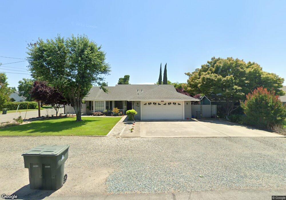
6922 College Ave Sutter, CA 95982
Estimated Value: $385,000 - $523,000
3
Beds
2
Baths
1,750
Sq Ft
$255/Sq Ft
Est. Value
About This Home
This home is located at 6922 College Ave, Sutter, CA 95982 and is currently estimated at $446,522, approximately $255 per square foot. 6922 College Ave is a home located in Sutter County with nearby schools including Brittan Elementary School, Sutter High School, and Christian Outreach Fellowship.
Ownership History
Date
Name
Owned For
Owner Type
Purchase Details
Closed on
Jun 21, 2018
Sold by
Takata Russell J and Takata Vicki A
Bought by
Takata Russell J and Takata Vickie A
Current Estimated Value
Purchase Details
Closed on
May 20, 2003
Sold by
Takata Russell J
Bought by
Takata Russell J and Takata Vicki A
Create a Home Valuation Report for This Property
The Home Valuation Report is an in-depth analysis detailing your home's value as well as a comparison with similar homes in the area
Home Values in the Area
Average Home Value in this Area
Purchase History
| Date | Buyer | Sale Price | Title Company |
|---|---|---|---|
| Takata Russell J | -- | None Available | |
| Takata Russell J | -- | First American Title Co |
Source: Public Records
Tax History
| Year | Tax Paid | Tax Assessment Tax Assessment Total Assessment is a certain percentage of the fair market value that is determined by local assessors to be the total taxable value of land and additions on the property. | Land | Improvement |
|---|---|---|---|---|
| 2025 | $2,177 | $209,197 | $63,111 | $146,086 |
| 2024 | $2,177 | $205,096 | $61,874 | $143,222 |
| 2023 | $2,177 | $201,075 | $60,661 | $140,414 |
| 2022 | $2,109 | $197,133 | $59,472 | $137,661 |
| 2021 | $2,089 | $193,302 | $58,324 | $134,978 |
| 2020 | $2,062 | $191,320 | $57,726 | $133,594 |
| 2019 | $2,243 | $187,569 | $56,594 | $130,975 |
| 2018 | $2,221 | $183,890 | $55,484 | $128,406 |
| 2017 | $2,111 | $180,285 | $54,396 | $125,889 |
| 2016 | $2,095 | $176,751 | $53,330 | $123,421 |
Source: Public Records
Map
Nearby Homes
- 2431 Madrone St
- 2130 Palm St
- 2227 W Ridge Dr
- 1939 1st Ave
- 1812 1st Ave
- 1244 Acacia Ave
- 5576 S Butte Rd
- 8454 Pass Rd
- 8970 S Butte Rd
- 2065 Howlett Ave
- 4423 Dresser Rd
- 4361 Dresser Rd
- 1650 N Township Rd
- 3456 Jefferson Ave
- 4472 Franklin Rd
- 3295 Jefferson Ave
- 3271 Stonegate Dr
- 3327 Sam Brannan Way
- 2127 Pepperwood Dr
- 0 Colusa Frontage Rd
- 6950 College Ave
- 2664 Cedar St
- 6850 College Ave
- 6971 College Ave
- 2685 Locust St
- 2636 Cedar St
- 2663 Locust St
- 2651 Cedar St
- 6949 College Ave
- 6836 College Ave
- 2641 Locust St
- 2713 Locust St
- 2616 Cedar St
- 2728 Cedar St
- 2617 Locust St
- 2615 Cedar St
- 2662 Cypress St
- 6824 College Ave
- 2727 Locust St
- 2584 Cedar St
Your Personal Tour Guide
Ask me questions while you tour the home.