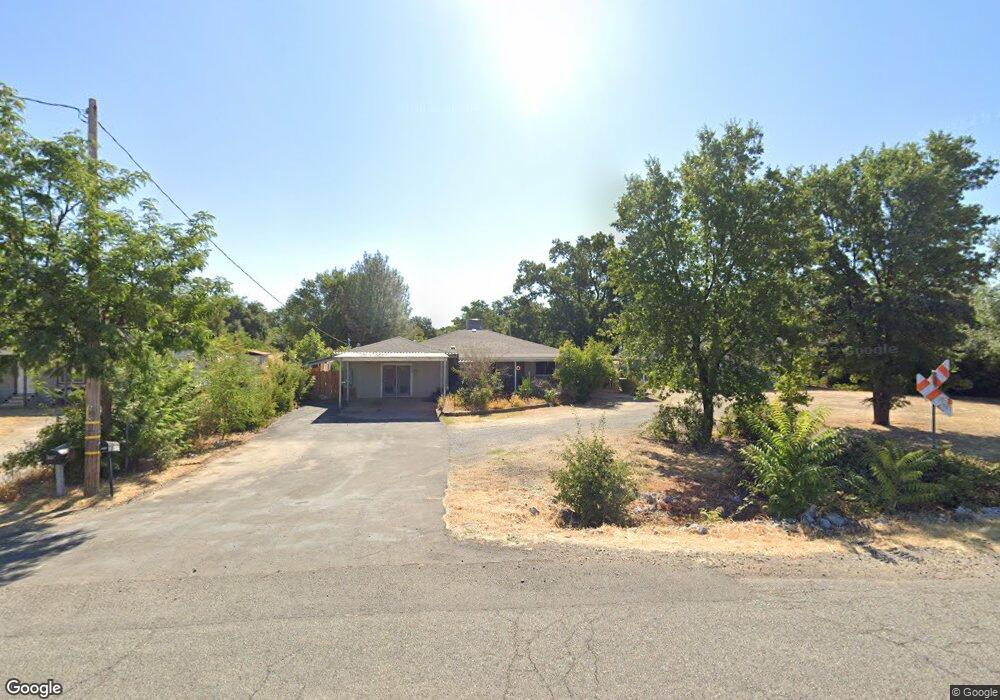
6933 Airport Rd Redding, CA 96002
Estimated Value: $329,441 - $489,000
2
Beds
2
Baths
1,624
Sq Ft
$236/Sq Ft
Est. Value
About This Home
This home is located at 6933 Airport Rd, Redding, CA 96002 and is currently estimated at $383,860, approximately $236 per square foot. 6933 Airport Rd is a home located in Shasta County with nearby schools including Prairie Elementary School, Pacheco Elementary School, and Northern Summit Academy.
Ownership History
Date
Name
Owned For
Owner Type
Purchase Details
Closed on
Jan 16, 2002
Sold by
Vanorden Randy J and Vanorden Jackie L
Bought by
Eye Charles R and Eye Denise M
Current Estimated Value
Home Financials for this Owner
Home Financials are based on the most recent Mortgage that was taken out on this home.
Original Mortgage
$93,000
Outstanding Balance
$38,355
Interest Rate
7.17%
Mortgage Type
Seller Take Back
Estimated Equity
$345,505
Create a Home Valuation Report for This Property
The Home Valuation Report is an in-depth analysis detailing your home's value as well as a comparison with similar homes in the area
Purchase History
| Date | Buyer | Sale Price | Title Company |
|---|---|---|---|
| Eye Charles R | $103,000 | Fidelity National Title Co |
Source: Public Records
Mortgage History
| Date | Status | Borrower | Loan Amount |
|---|---|---|---|
| Open | Eye Charles R | $93,000 |
Source: Public Records
Tax History
| Year | Tax Paid | Tax Assessment Tax Assessment Total Assessment is a certain percentage of the fair market value that is determined by local assessors to be the total taxable value of land and additions on the property. | Land | Improvement |
|---|---|---|---|---|
| 2025 | $1,877 | $191,218 | $44,305 | $146,913 |
| 2024 | $1,838 | $179,970 | $43,437 | $136,533 |
| 2023 | $1,838 | $176,442 | $42,586 | $133,856 |
| 2022 | $1,791 | $172,983 | $41,751 | $131,232 |
| 2021 | $1,761 | $169,592 | $40,933 | $128,659 |
| 2020 | $1,739 | $167,854 | $40,514 | $127,340 |
| 2019 | $1,715 | $164,564 | $39,720 | $124,844 |
| 2018 | $1,647 | $161,339 | $38,942 | $122,397 |
| 2017 | $1,668 | $158,177 | $38,179 | $119,998 |
| 2016 | $1,576 | $155,077 | $37,431 | $117,646 |
| 2015 | $1,574 | $152,748 | $36,869 | $115,879 |
| 2014 | $1,554 | $149,757 | $36,147 | $113,610 |
Source: Public Records
Map
Nearby Homes
- 20573 Sunset Ln
- 20577 Sunset Ln
- 20350 Hole In 1 Dr
- 20350 Hole in One Dr
- 6690 Curtis Ln
- 6685 Scenic Oak Ct
- 0000 Riata Dr
- 6927 Riata Dr
- 6908 Riata Dr
- 7530 Lockheed Dr
- 7520 Lockheed Dr
- 20260 River Valley Dr
- 7067 Tucker Ln
- 7036 Tucker Ln
- 7587 Fiesta Way
- 7100 Amigo Way
- 7501 Fiesta Way
- 7273 Amigo Way
- 7213 Amigo Way
- 0 19 Acres Off Scheer Dr
- 6937 Skyway St
- 6941 Skyway St
- 8187 Airport Rd
- 6945 Skyway St
- 6903 Airport Rd
- 20538 Lassen View Ln
- 6885 Airport Rd
- 6944 Russell Ln
- 20550 Lassen View Ln
- 6953 Skyway St
- 6963 Skyway St
- 6917 Russell Ln
- 6911 Russell Ln
- 6931 Russell Ln
- 6869 Airport Rd
- 6943 Russell Ln
- 8340 Airport Rd
- 6953 Russell Ln
- 20528 Sunset Ln
- 11.5 Acres Lassen View Ln
Your Personal Tour Guide
Ask me questions while you tour the home.