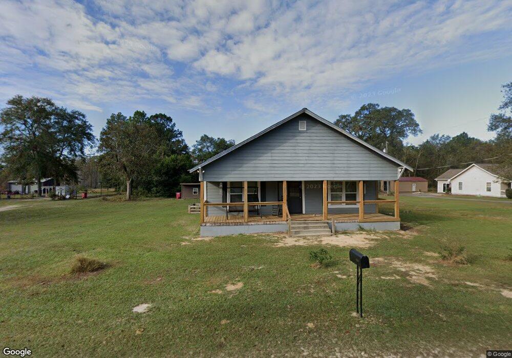
6937 Clark Rd Blackshear, GA 31516
Estimated Value: $126,272 - $221,000
3
Beds
1
Bath
1,505
Sq Ft
$115/Sq Ft
Est. Value
About This Home
This home is located at 6937 Clark Rd, Blackshear, GA 31516 and is currently estimated at $173,818, approximately $115 per square foot. 6937 Clark Rd is a home located in Pierce County with nearby schools including Pierce County High School.
Ownership History
Date
Name
Owned For
Owner Type
Purchase Details
Closed on
May 16, 2016
Sold by
Walter Ralph Thomas
Bought by
Walter Felicia Lea
Current Estimated Value
Home Financials for this Owner
Home Financials are based on the most recent Mortgage that was taken out on this home.
Original Mortgage
$10,000,000
Outstanding Balance
$7,896,487
Interest Rate
3.58%
Mortgage Type
New Conventional
Estimated Equity
-$7,722,669
Purchase Details
Closed on
Mar 17, 2015
Sold by
Clark John A
Bought by
Walter Ralph Thomas and Walter Felicia Lea
Home Financials for this Owner
Home Financials are based on the most recent Mortgage that was taken out on this home.
Original Mortgage
$10,000,000
Interest Rate
3.87%
Mortgage Type
New Conventional
Purchase Details
Closed on
Jan 16, 1980
Sold by
Clark G A
Bought by
Clark John A
Purchase Details
Closed on
Mar 29, 1966
Bought by
Clark G A
Create a Home Valuation Report for This Property
The Home Valuation Report is an in-depth analysis detailing your home's value as well as a comparison with similar homes in the area
Purchase History
| Date | Buyer | Sale Price | Title Company |
|---|---|---|---|
| Walter Felicia Lea | -- | -- | |
| Walter Ralph Thomas | $20,000 | -- | |
| Clark John A | $25,000 | -- | |
| Clark G A | -- | -- |
Source: Public Records
Mortgage History
| Date | Status | Borrower | Loan Amount |
|---|---|---|---|
| Open | Walter Felicia Lea | $10,000,000 | |
| Previous Owner | Walter Ralph Thomas | $10,000,000 |
Source: Public Records
Tax History
| Year | Tax Paid | Tax Assessment Tax Assessment Total Assessment is a certain percentage of the fair market value that is determined by local assessors to be the total taxable value of land and additions on the property. | Land | Improvement |
|---|---|---|---|---|
| 2025 | $814 | $39,660 | $3,248 | $36,412 |
| 2024 | $814 | $38,194 | $3,248 | $34,946 |
| 2023 | $861 | $36,763 | $3,248 | $33,515 |
| 2022 | $255 | $9,424 | $2,394 | $7,030 |
| 2021 | $243 | $9,160 | $2,394 | $6,766 |
| 2020 | $239 | $8,896 | $2,394 | $6,502 |
| 2019 | $241 | $8,896 | $2,394 | $6,502 |
| 2018 | $230 | $8,518 | $2,280 | $6,238 |
| 2017 | $224 | $8,140 | $2,280 | $5,860 |
| 2016 | $218 | $8,140 | $2,280 | $5,860 |
| 2015 | $38 | $8,140 | $2,280 | $5,860 |
| 2014 | $38 | $8,140 | $2,280 | $5,860 |
| 2013 | $38 | $8,140 | $2,280 | $5,860 |
Source: Public Records
Map
Nearby Homes
- 6622 Georgia 121
- 00 White Tail Way
- 4160 Deerwood Ln
- 4003 Oxford Ln
- 6254 Bluebird Dr
- 6929 Greenfield Rd
- 6930 Greenfield Rd
- 6923 Greenfield Rd
- 6927 Greenfield Rd
- 6934 Greenfield Rd
- 6935 Greenfield Rd
- 7312 Blue Lake Cir
- 35 Acres + - Willie Bowen Rd
- 4131 Mulligan Cir
- 4125 Mulligan Cir
- 157 Hwy
- 6553 Kenny Ln
- 4005 Golfview Dr
- 40 Palmetto Path
- 0 Southside Dr
Your Personal Tour Guide
Ask me questions while you tour the home.