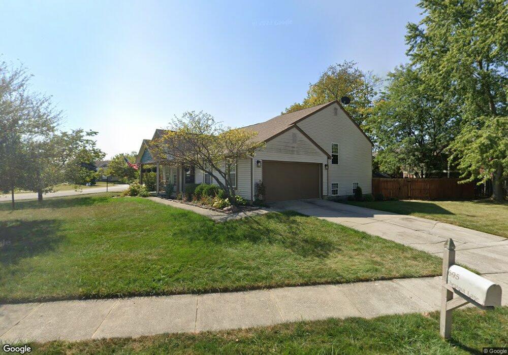
695 Chestnut Ln Brownsburg, IN 46112
Estimated Value: $303,000 - $308,000
3
Beds
2
Baths
1,719
Sq Ft
$177/Sq Ft
Est. Value
About This Home
This home is located at 695 Chestnut Ln, Brownsburg, IN 46112 and is currently estimated at $304,990, approximately $177 per square foot. 695 Chestnut Ln is a home located in Hendricks County with nearby schools including Lincoln Elementary, Brownsburg East Middle School, and Brownsburg High School.
Ownership History
Date
Name
Owned For
Owner Type
Purchase Details
Closed on
Dec 3, 2020
Sold by
Haese Bob and Haese Diane
Bought by
Haese Stein
Current Estimated Value
Purchase Details
Closed on
Aug 26, 2010
Sold by
Fannie Mae
Bought by
Haese Bob and Haese Diane
Purchase Details
Closed on
Sep 17, 2009
Sold by
Worl Lawrence
Bought by
Fannie Mae
Create a Home Valuation Report for This Property
The Home Valuation Report is an in-depth analysis detailing your home's value as well as a comparison with similar homes in the area
Home Values in the Area
Average Home Value in this Area
Purchase History
| Date | Buyer | Sale Price | Title Company |
|---|---|---|---|
| Haese Stein | -- | None Available | |
| Haese Bob | $72,000 | None Available | |
| Fannie Mae | $151,598 | None Available |
Source: Public Records
Tax History Compared to Growth
Tax History
| Year | Tax Paid | Tax Assessment Tax Assessment Total Assessment is a certain percentage of the fair market value that is determined by local assessors to be the total taxable value of land and additions on the property. | Land | Improvement |
|---|---|---|---|---|
| 2024 | $4,048 | $280,700 | $49,900 | $230,800 |
| 2023 | $3,664 | $263,100 | $45,800 | $217,300 |
| 2022 | $3,055 | $219,100 | $42,400 | $176,700 |
| 2021 | $1,891 | $189,100 | $38,600 | $150,500 |
| 2020 | $1,796 | $179,600 | $38,600 | $141,000 |
| 2019 | $3,270 | $163,500 | $36,700 | $126,800 |
| 2018 | $3,128 | $156,400 | $36,700 | $119,700 |
| 2017 | $2,864 | $143,200 | $34,000 | $109,200 |
| 2016 | $2,814 | $140,700 | $34,000 | $106,700 |
| 2014 | $2,376 | $118,800 | $31,200 | $87,600 |
Source: Public Records
Map
Nearby Homes
- 725 Hawthorne Ln
- 1208 Brittany Cir Unit A
- 1208 Whittington Dr
- 1202 Whittington Dr
- 1415 Beaumont Cir
- 1505 Arbor Springs Dr
- Wexford Plan at Forest Hill
- 1284 Summer Ridge Ln
- 1280 Summer Ridge Ln
- 1113 River Ridge Dr
- 203 Woodside Ct
- 7215 Barrett Dr
- 7242 Barrett Dr
- 7250 N State Road 267
- 1327 Blue Ridge Ln
- 7252 Barrett Dr
- Promenade Farmhouse Plan at Centennial at Brownsburg - Centennial of Brownsburg
- Promenade Craftsman Plan at Centennial at Brownsburg - Centennial of Brownsburg
- Portico Plan at Centennial at Brownsburg - Centennial of Brownsburg
- Palazzo Plan at Centennial at Brownsburg - Centennial of Brownsburg
- 1274 Auburn Dr
- 0 Chestnut Ln
- 1266 Auburn Dr
- 1318 Auburn Dr
- 705 Chestnut Ln
- 704 Rose Ln
- 1258 Auburn Dr
- 1326 Auburn Dr
- 709 Chestnut Ln
- 706 Chestnut Ln
- 1250 Auburn Dr
- 713 Chestnut Ln
- 1229 Brittany Cir
- 1334 Auburn Dr
- 712 Rose Ln
- 710 Chestnut Ln
- 1242 Auburn Dr
- 703 Rose Ln
- 707 Hawthorne Ln
- 1231 Brittany Cir