Estimated Value: $281,000 - $326,000
3
Beds
2
Baths
1,484
Sq Ft
$205/Sq Ft
Est. Value
About This Home
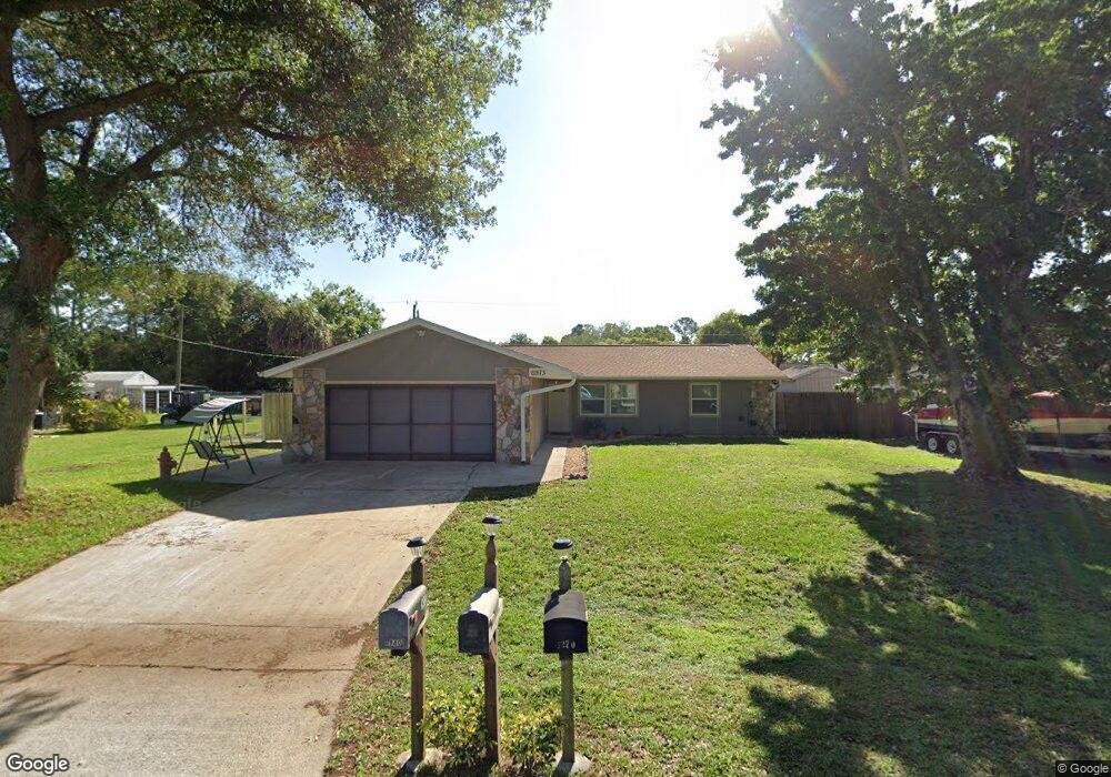
This home is located at 6973 Bryant Rd, Cocoa, FL 32927 and is currently estimated at $304,486, approximately $205 per square foot. 6973 Bryant Rd is a home located in Brevard County with nearby schools including Enterprise Elementary School, Space Coast Junior/Senior High School, and Sculptor Charter School.
Ownership History
Date
Name
Owned For
Owner Type
Purchase Details
Closed on
Feb 22, 2016
Sold by
Ordner Cody G and Ordner Jessica L
Bought by
Ordner Cody G and Ordner Jessica L
Current Estimated Value
Home Financials for this Owner
Home Financials are based on the most recent Mortgage that was taken out on this home.
Original Mortgage
$97,595
Outstanding Balance
$71,203
Interest Rate
4.12%
Mortgage Type
FHA
Estimated Equity
$233,283
Purchase Details
Closed on
Mar 25, 2009
Sold by
U S Bank Na
Bought by
Ordner Cody G and Ordner Jessica L
Home Financials for this Owner
Home Financials are based on the most recent Mortgage that was taken out on this home.
Original Mortgage
$99,857
Interest Rate
5.01%
Purchase Details
Closed on
Jul 9, 2008
Sold by
Kershaw James R and Kershaw Lois M
Bought by
Us Bank Na and Mastr Asset Backed Securities Trust 2006
Purchase Details
Closed on
Mar 30, 1998
Sold by
Ledbetter Otis W and Ledbetter Eva L
Bought by
Kershaw James R and Kershaw Lois M
Home Financials for this Owner
Home Financials are based on the most recent Mortgage that was taken out on this home.
Original Mortgage
$71,421
Interest Rate
6.95%
Purchase Details
Closed on
Sep 26, 1997
Sold by
Simmons Bruce Edward and Simmons Barbara S
Bought by
Ledbetter Otis W and Ledbetter Eva L
Home Financials for this Owner
Home Financials are based on the most recent Mortgage that was taken out on this home.
Original Mortgage
$47,000
Interest Rate
7.6%
Create a Home Valuation Report for This Property
The Home Valuation Report is an in-depth analysis detailing your home's value as well as a comparison with similar homes in the area
Home Values in the Area
Average Home Value in this Area
Purchase History
| Date | Buyer | Sale Price | Title Company |
|---|---|---|---|
| Ordner Cody G | -- | Attorney | |
| Ordner Cody G | $93,000 | Oak Ridge Title Inc | |
| Us Bank Na | -- | None Available | |
| Kershaw James R | $71,500 | -- | |
| Ledbetter Otis W | $72,000 | -- |
Source: Public Records
Mortgage History
| Date | Status | Borrower | Loan Amount |
|---|---|---|---|
| Open | Ordner Cody G | $97,595 | |
| Previous Owner | Ordner Cody G | $99,857 | |
| Previous Owner | Kershaw James R | $71,421 | |
| Previous Owner | Ledbetter Otis W | $47,000 |
Source: Public Records
Tax History
| Year | Tax Paid | Tax Assessment Tax Assessment Total Assessment is a certain percentage of the fair market value that is determined by local assessors to be the total taxable value of land and additions on the property. | Land | Improvement |
|---|---|---|---|---|
| 2025 | $1,112 | $78,130 | -- | -- |
| 2024 | $1,084 | $75,930 | -- | -- |
| 2023 | $1,084 | $73,720 | $0 | $0 |
| 2022 | $1,024 | $71,580 | $0 | $0 |
| 2021 | $1,024 | $69,500 | $0 | $0 |
| 2020 | $966 | $68,550 | $0 | $0 |
| 2019 | $913 | $67,010 | $0 | $0 |
| 2018 | $913 | $65,770 | $0 | $0 |
| 2017 | $2,191 | $114,400 | $24,000 | $90,400 |
| 2016 | $920 | $63,100 | $18,000 | $45,100 |
| 2015 | $927 | $62,670 | $15,000 | $47,670 |
| 2014 | $932 | $62,180 | $11,000 | $51,180 |
Source: Public Records
Map
Nearby Homes
- 6990 Bryant Rd
- 5165 Patricia St
- 5155 Mayflower St
- 7065 Hundred Acre Dr
- 6815 Bryant Rd
- 5080 Mayflower St
- 5555 Brandon St
- 7230 Venus Ave
- 6760 Cairo Rd
- 5200 Frisco St
- 7155 Export Ave
- 5150 Melody St
- 7635 Fringe Place
- 7200 Oakwood Ave
- 5095 Hogan Place
- 7545 Fringe Place
- 6615 Dock Ave
- 7275 Durban Ave
- 7310 Joshua Place
- 7245 Grissom Pkwy
Your Personal Tour Guide
Ask me questions while you tour the home.