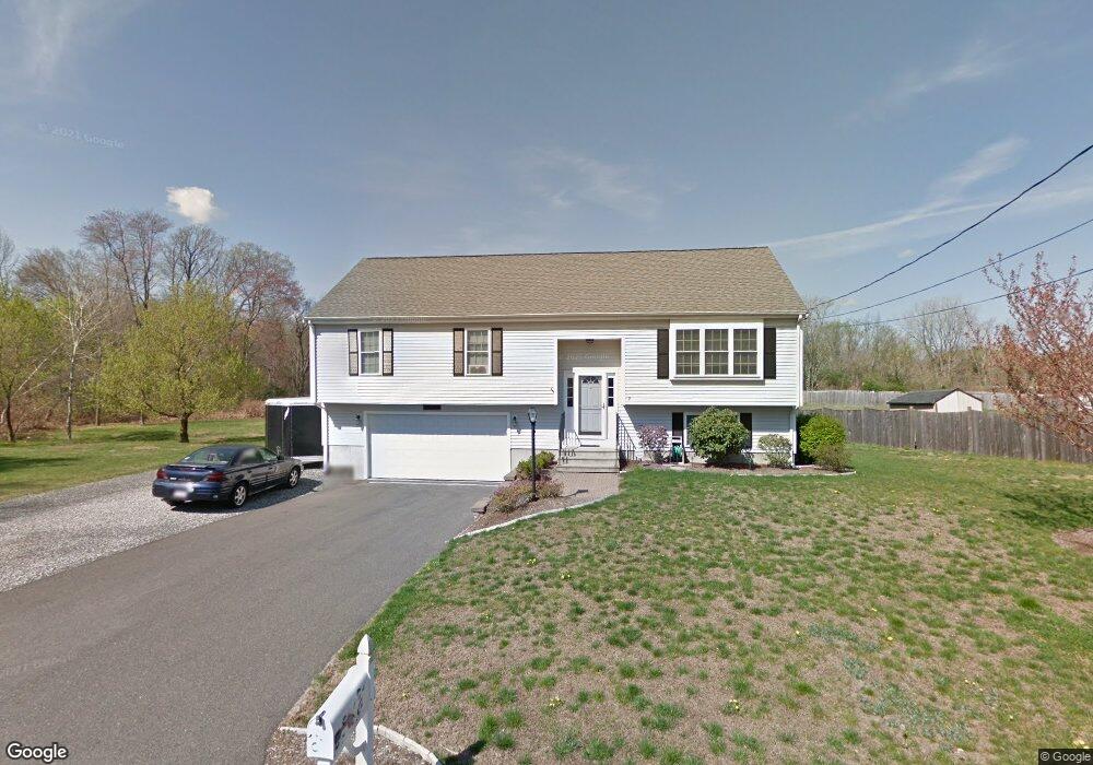
7 9th Ave Brockton, MA 02302
Campello NeighborhoodEstimated Value: $615,000 - $676,000
3
Beds
2
Baths
2,120
Sq Ft
$305/Sq Ft
Est. Value
About This Home
This home is located at 7 9th Ave, Brockton, MA 02302 and is currently estimated at $646,818, approximately $305 per square foot. 7 9th Ave is a home located in Plymouth County with nearby schools including Gilmore Elementary School, Davis K-8 School, and John F. Kennedy Elementary School.
Ownership History
Date
Name
Owned For
Owner Type
Purchase Details
Closed on
Oct 31, 2007
Sold by
Kuskoski Chester E
Bought by
Kuskoski Chester E and Kuskoski Terri
Current Estimated Value
Purchase Details
Closed on
Jan 7, 2005
Sold by
Butler Richard D
Bought by
Carpentry Klk
Purchase Details
Closed on
Aug 23, 2004
Sold by
Klk Carpentry and Klk Remo I
Bought by
Kuskoski Chester E
Purchase Details
Closed on
Aug 6, 2004
Sold by
Butler Richard D
Bought by
Carpentry Klk and Carpentry Emode L
Create a Home Valuation Report for This Property
The Home Valuation Report is an in-depth analysis detailing your home's value as well as a comparison with similar homes in the area
Home Values in the Area
Average Home Value in this Area
Purchase History
| Date | Buyer | Sale Price | Title Company |
|---|---|---|---|
| Kuskoski Chester E | -- | -- | |
| Carpentry Klk | $115,000 | -- | |
| Kuskoski Chester E | $359,900 | -- | |
| Carpentry Klk | $100,000 | -- |
Source: Public Records
Mortgage History
| Date | Status | Borrower | Loan Amount |
|---|---|---|---|
| Open | Carpentry Klk | $372,505 | |
| Closed | Carpentry Klk | $368,231 |
Source: Public Records
Tax History Compared to Growth
Tax History
| Year | Tax Paid | Tax Assessment Tax Assessment Total Assessment is a certain percentage of the fair market value that is determined by local assessors to be the total taxable value of land and additions on the property. | Land | Improvement |
|---|---|---|---|---|
| 2025 | $6,990 | $577,200 | $143,500 | $433,700 |
| 2024 | $6,918 | $575,500 | $143,500 | $432,000 |
| 2023 | $6,535 | $503,500 | $121,000 | $382,500 |
| 2022 | $5,933 | $424,700 | $110,100 | $314,600 |
| 2021 | $13,980 | $391,500 | $95,200 | $296,300 |
| 2020 | $13,027 | $378,700 | $85,700 | $293,000 |
| 2019 | $12,826 | $377,400 | $82,300 | $295,100 |
| 2018 | $5,264 | $327,800 | $82,300 | $245,500 |
| 2017 | $11,546 | $309,200 | $82,300 | $226,900 |
| 2016 | $5,448 | $313,800 | $81,000 | $232,800 |
| 2015 | $5,385 | $296,700 | $81,000 | $215,700 |
| 2014 | $5,089 | $280,700 | $81,000 | $199,700 |
Source: Public Records
Map
Nearby Homes
- 122 Sinclair Rd
- 24 Ithica Rd
- 163 S Leyden St
- 221 Sinclair Rd
- 229 Sinclair Rd
- 139 Geralynn Dr
- 768 East St
- 578 Plain St
- 44 Baker St
- 597 East St
- 12 Paulin Ave
- 15 Longworth Ave Unit 231
- 35 Longworth Ave Unit 17
- 1435 Main St
- 16 Yuba Cir
- 1 Thomas Cir
- 112 Hillside Ave
- 16 Friendship Dr
- 28 Wallace St
- 358 Copeland St