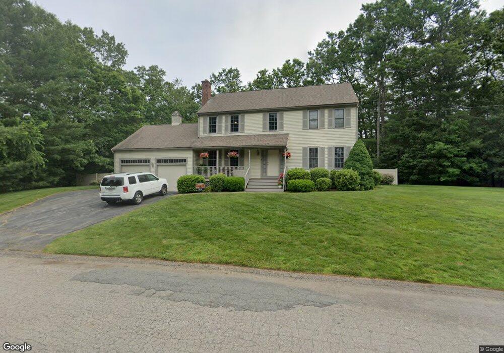
7 Anthony Rd South Easton, MA 02375
Estimated Value: $864,875 - $945,000
4
Beds
3
Baths
2,184
Sq Ft
$413/Sq Ft
Est. Value
About This Home
This home is located at 7 Anthony Rd, South Easton, MA 02375 and is currently estimated at $901,219, approximately $412 per square foot. 7 Anthony Rd is a home located in Bristol County with nearby schools including Easton Middle School, Oliver Ames High School, and St Mary's Catholic School.
Ownership History
Date
Name
Owned For
Owner Type
Purchase Details
Closed on
Jun 30, 2000
Sold by
Hometown Builders Inc
Bought by
Fini William Y and Hirschorn Karen L
Current Estimated Value
Purchase Details
Closed on
Jul 9, 1999
Sold by
5 Anthony Road Rt and Peterson
Bought by
Cid Rt and Cidado
Purchase Details
Closed on
Feb 9, 1996
Sold by
L&M Rt and Peterson Maryanne
Bought by
Peterson Elizabeth
Create a Home Valuation Report for This Property
The Home Valuation Report is an in-depth analysis detailing your home's value as well as a comparison with similar homes in the area
Home Values in the Area
Average Home Value in this Area
Purchase History
| Date | Buyer | Sale Price | Title Company |
|---|---|---|---|
| Fini William Y | $340,000 | -- | |
| Fini William Y | $340,000 | -- | |
| Cid Rt | $60,000 | -- | |
| Cid Rt | $60,000 | -- | |
| Cid Rt | $60,000 | -- | |
| Peterson Elizabeth | $80,000 | -- | |
| Peterson Elizabeth | $80,000 | -- |
Source: Public Records
Mortgage History
| Date | Status | Borrower | Loan Amount |
|---|---|---|---|
| Open | Peterson Elizabeth | $300,000 | |
| Closed | Peterson Elizabeth | $285,000 |
Source: Public Records
Tax History Compared to Growth
Tax History
| Year | Tax Paid | Tax Assessment Tax Assessment Total Assessment is a certain percentage of the fair market value that is determined by local assessors to be the total taxable value of land and additions on the property. | Land | Improvement |
|---|---|---|---|---|
| 2025 | $9,484 | $759,900 | $368,500 | $391,400 |
| 2024 | $9,851 | $737,900 | $347,600 | $390,300 |
| 2023 | $9,717 | $666,000 | $347,600 | $318,400 |
| 2022 | $9,086 | $590,400 | $283,800 | $306,600 |
| 2021 | $8,749 | $565,200 | $258,600 | $306,600 |
| 2020 | $8,404 | $546,400 | $248,700 | $297,700 |
| 2019 | $8,593 | $538,400 | $248,700 | $289,700 |
| 2018 | $8,429 | $520,000 | $248,700 | $271,300 |
| 2017 | $8,138 | $501,700 | $248,700 | $253,000 |
| 2016 | $8,236 | $508,700 | $248,700 | $260,000 |
| 2015 | $7,757 | $462,300 | $202,300 | $260,000 |
| 2014 | $7,689 | $461,800 | $205,100 | $256,700 |
Source: Public Records
Map
Nearby Homes
- 157 Highland St
- 154 Highland St
- 27 Necco Rd
- 11 Hilltop Ln
- 1360 East St
- 6 Pinebrook Ln Unit 6
- 36 Sierra Dr
- 28 Heidi Rd
- 108 Norton Ave Unit 24
- 108 Norton Ave Unit 4
- 23 Estelle Marsan Dr
- 34 Kevins Way
- 55 Eastman St
- 96 Kevins Way
- 11 Kathleen Grant Rd
- 9 Shagbark Rd
- 43 Kathleen Grant Rd
- 18 Millfarm Dr
- 4 Plantation Rd
- 46 Kerry Dr
- 7 Marjac Rd
- 6 Anthony Rd
- 10 Marjac Rd
- 5 Anthony Rd
- lot 5 Tony Dr
- 11 Marjac Rd
- 167 Highland St
- 163 Highland St Unit B
- 163 Highland St Unit A
- 163 Highland St Unit 163/A
- 14 Marjac Rd
- 167 Highland St
- 15 Marjac Rd
- 18 Marjac Rd
- 90-92 North St
- 92 North St
- 90 North St Unit 92
- 90 North St Unit 90
- 19 Marjac Way
- 153 Highland St