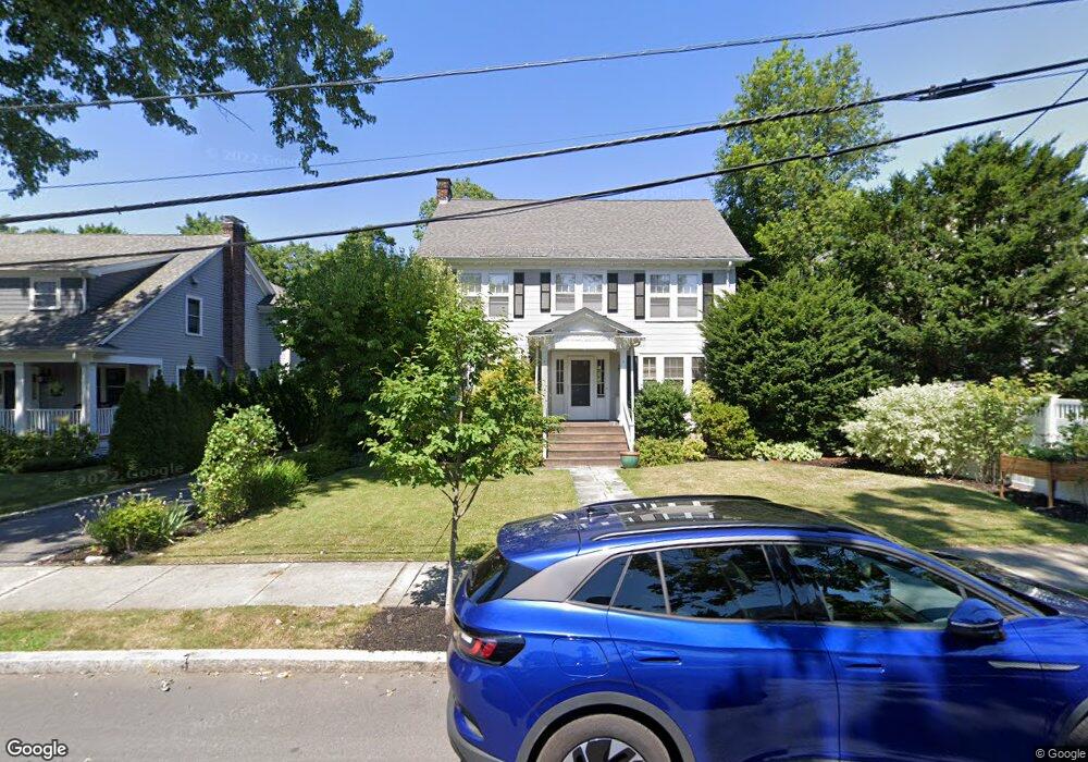
7 Concolor Ave Newton, MA 02458
Newton Corner NeighborhoodEstimated Value: $1,630,000 - $1,880,000
4
Beds
4
Baths
2,543
Sq Ft
$671/Sq Ft
Est. Value
About This Home
This home is located at 7 Concolor Ave, Newton, MA 02458 and is currently estimated at $1,707,588, approximately $671 per square foot. 7 Concolor Ave is a home located in Middlesex County with nearby schools including Cabot Elementary School, F.A. Day Middle School, and Newton North High School.
Ownership History
Date
Name
Owned For
Owner Type
Purchase Details
Closed on
Aug 14, 2020
Sold by
Bancroft Daniel A and Swanson-Bancroft Anne B
Bought by
Noble Brian P and Noble Elizabeth H
Current Estimated Value
Home Financials for this Owner
Home Financials are based on the most recent Mortgage that was taken out on this home.
Original Mortgage
$800,000
Outstanding Balance
$706,997
Interest Rate
2.8%
Mortgage Type
Purchase Money Mortgage
Estimated Equity
$1,000,591
Purchase Details
Closed on
Jul 15, 2016
Sold by
Bancroft Daniel A and Swanson-Swanson Anne B
Bought by
Bancroft Daniel A and Swanson-Bancroft Anne B
Purchase Details
Closed on
Aug 25, 1989
Sold by
Burke Priscilla H
Bought by
Bancroft Daniel A
Create a Home Valuation Report for This Property
The Home Valuation Report is an in-depth analysis detailing your home's value as well as a comparison with similar homes in the area
Home Values in the Area
Average Home Value in this Area
Purchase History
| Date | Buyer | Sale Price | Title Company |
|---|---|---|---|
| Noble Brian P | $1,100,000 | None Available | |
| Bancroft Daniel A | -- | -- | |
| Bancroft Daniel A | $322,000 | -- |
Source: Public Records
Mortgage History
| Date | Status | Borrower | Loan Amount |
|---|---|---|---|
| Open | Noble Brian P | $800,000 | |
| Previous Owner | Bancroft Daniel A | $416,000 | |
| Previous Owner | Bancroft Daniel A | $417,000 | |
| Previous Owner | Bancroft Daniel A | $417,000 |
Source: Public Records
Tax History
| Year | Tax Paid | Tax Assessment Tax Assessment Total Assessment is a certain percentage of the fair market value that is determined by local assessors to be the total taxable value of land and additions on the property. | Land | Improvement |
|---|---|---|---|---|
| 2025 | $12,475 | $1,273,000 | $1,006,500 | $266,500 |
| 2024 | $12,062 | $1,235,900 | $977,200 | $258,700 |
| 2023 | $11,610 | $1,140,500 | $745,600 | $394,900 |
| 2022 | $11,109 | $1,056,000 | $690,400 | $365,600 |
| 2021 | $9,517 | $884,500 | $651,300 | $233,200 |
| 2020 | $9,234 | $884,500 | $651,300 | $233,200 |
| 2019 | $6,622 | $858,700 | $632,300 | $226,400 |
| 2018 | $8,620 | $796,700 | $571,600 | $225,100 |
| 2017 | $8,322 | $748,400 | $539,200 | $209,200 |
| 2016 | $7,959 | $699,400 | $503,900 | $195,500 |
| 2015 | $7,588 | $653,600 | $470,900 | $182,700 |
Source: Public Records
Map
Nearby Homes
- 0 Claremont St
- 33 George St Unit 33
- 35 George St Unit 35
- 37 George St Unit 37
- 59 Hyde Ave
- 123 Sargent St
- 549 Centre St Unit 2
- 84 E Side Pkwy Unit 84
- 327 Franklin St
- 97 Eldredge St
- 216 Newtonville Ave Unit 218
- 269 Franklin St
- 47 Blake St Unit 47
- 17 Lancaster Rd
- 129 Withington Rd Unit 129
- 22 Brackett Rd
- 68 Vernon St
- 9 Baldwin St Unit 15C
- 48 Harvard St Unit 1
- 15 Farlow Rd
Your Personal Tour Guide
Ask me questions while you tour the home.