Estimated Value: $1,150,976 - $1,333,000
4
Beds
3
Baths
2,935
Sq Ft
$420/Sq Ft
Est. Value
About This Home
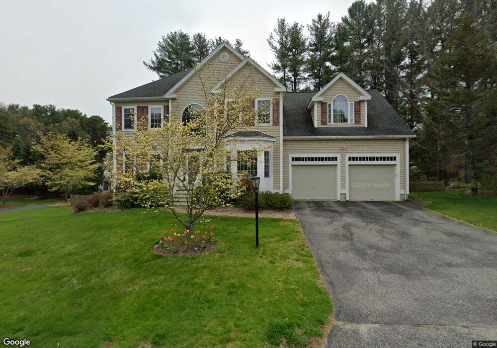
This home is located at 7 Dunham Ln, Acton, MA 01720 and is currently estimated at $1,232,494, approximately $419 per square foot. 7 Dunham Ln is a home located in Middlesex County with nearby schools including Acton-Boxborough Regional High School, Maynard Knowledge Beginnings, and The Imago School.
Ownership History
Date
Name
Owned For
Owner Type
Purchase Details
Closed on
Jun 3, 2003
Sold by
Bentley Building Corp
Bought by
Browning Beth G and Browning Colin R
Current Estimated Value
Home Financials for this Owner
Home Financials are based on the most recent Mortgage that was taken out on this home.
Original Mortgage
$250,000
Outstanding Balance
$110,147
Interest Rate
5.86%
Mortgage Type
Purchase Money Mortgage
Estimated Equity
$1,122,347
Create a Home Valuation Report for This Property
The Home Valuation Report is an in-depth analysis detailing your home's value as well as a comparison with similar homes in the area
Home Values in the Area
Average Home Value in this Area
Purchase History
| Date | Buyer | Sale Price | Title Company |
|---|---|---|---|
| Browning Beth G | $675,000 | -- |
Source: Public Records
Mortgage History
| Date | Status | Borrower | Loan Amount |
|---|---|---|---|
| Open | Browning Beth G | $250,000 |
Source: Public Records
Tax History Compared to Growth
Tax History
| Year | Tax Paid | Tax Assessment Tax Assessment Total Assessment is a certain percentage of the fair market value that is determined by local assessors to be the total taxable value of land and additions on the property. | Land | Improvement |
|---|---|---|---|---|
| 2025 | $18,923 | $1,103,400 | $336,000 | $767,400 |
| 2024 | $17,575 | $1,054,300 | $336,000 | $718,300 |
| 2023 | $17,182 | $978,500 | $305,400 | $673,100 |
| 2022 | $16,589 | $852,900 | $265,500 | $587,400 |
| 2021 | $16,226 | $802,100 | $245,900 | $556,200 |
| 2020 | $15,282 | $794,300 | $245,900 | $548,400 |
| 2019 | $14,582 | $752,800 | $245,900 | $506,900 |
| 2018 | $14,386 | $742,300 | $245,900 | $496,400 |
| 2017 | $13,994 | $734,200 | $245,900 | $488,300 |
| 2016 | $13,651 | $709,900 | $245,900 | $464,000 |
| 2015 | $13,367 | $701,700 | $245,900 | $455,800 |
| 2014 | $12,874 | $661,900 | $245,900 | $416,000 |
Source: Public Records
Map
Nearby Homes
- 1 Maillet Dr
- 132 Parker St Unit G5
- 96 Forest Ridge Rd Unit 96
- 128 Parker St Unit 3B
- 9 Black Birch Ln Unit 9
- 118 Parker St Unit 16
- 29 Black Birch Ln Unit 29
- 2 & 6 Powder Mill Rd
- 69 Powder Mill Rd
- 66 Powder Mill Rd
- 2 Clover Hill Rd
- 80 N Branch Rd
- 7 King St
- 20 Tremont St
- 22 Garfield Ave
- 12 Walcott St
- 369 Border Rd
- 12 Brewster Ln
- 37 Glendale St
- 17 Prospect St