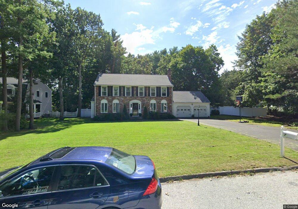
7 Fieldstone Dr Medfield, MA 02052
Estimated Value: $1,166,000 - $1,321,000
4
Beds
3
Baths
3,600
Sq Ft
$352/Sq Ft
Est. Value
About This Home
This home is located at 7 Fieldstone Dr, Medfield, MA 02052 and is currently estimated at $1,268,629, approximately $352 per square foot. 7 Fieldstone Dr is a home located in Norfolk County with nearby schools including Ralph Wheelock School, Memorial School, and Dale Street School.
Ownership History
Date
Name
Owned For
Owner Type
Purchase Details
Closed on
Jun 15, 2017
Sold by
Wilkinson Craig
Bought by
Wilkinson Craig D and Wilkinson Michelle H
Current Estimated Value
Home Financials for this Owner
Home Financials are based on the most recent Mortgage that was taken out on this home.
Original Mortgage
$424,000
Interest Rate
4.3%
Mortgage Type
New Conventional
Purchase Details
Closed on
Apr 28, 2017
Sold by
Miller Charles Q and Miller Martha P
Bought by
Wilkinson Craig
Home Financials for this Owner
Home Financials are based on the most recent Mortgage that was taken out on this home.
Original Mortgage
$424,000
Interest Rate
4.3%
Mortgage Type
New Conventional
Purchase Details
Closed on
Nov 19, 2010
Sold by
Mccarthy Gerald J and Mccarthy Marianne E
Bought by
Miller Charles Q and Miller Martha P
Home Financials for this Owner
Home Financials are based on the most recent Mortgage that was taken out on this home.
Original Mortgage
$523,000
Interest Rate
4.3%
Mortgage Type
Purchase Money Mortgage
Purchase Details
Closed on
Mar 12, 2008
Sold by
Mccarthy Gerald J
Bought by
7 Fieldstone Drive Rt and Mccarthy
Purchase Details
Closed on
Mar 28, 2005
Sold by
Mccarthy Gerald F and Mccarthy Marianne E
Bought by
7 Fieldstone Drive Rt and Mccarthy
Purchase Details
Closed on
Jan 7, 2005
Sold by
Mccarthy Gerald J and Mccarthy Marianne E
Bought by
7 Fieldstone Drive Rt and Mccarthy
Purchase Details
Closed on
Mar 8, 2004
Sold by
Mccarthy Gerald J and Mccarthy Marianne E
Bought by
Mccarthy Gerald J and Mccarthy Marianne E
Create a Home Valuation Report for This Property
The Home Valuation Report is an in-depth analysis detailing your home's value as well as a comparison with similar homes in the area
Home Values in the Area
Average Home Value in this Area
Purchase History
| Date | Buyer | Sale Price | Title Company |
|---|---|---|---|
| Wilkinson Craig D | -- | -- | |
| Wilkinson Craig D | -- | -- | |
| Wilkinson Craig | $840,180 | -- | |
| Wilkinson Craig | $840,180 | -- | |
| Miller Charles Q | $680,000 | -- | |
| Miller Charles Q | $680,000 | -- | |
| 7 Fieldstone Drive Rt | -- | -- | |
| Mccarthy Gerald J | -- | -- | |
| Mccarthy Gerald J | -- | -- | |
| 7 Fieldstone Drive Rt | -- | -- | |
| Mccarthy Gerald J | -- | -- | |
| 7 Fieldstone Drive Rt | -- | -- | |
| Mccarthy Gerald F | -- | -- | |
| Mccarthy Gerald F | -- | -- | |
| 7 Fieldstone Drive Rt | -- | -- | |
| Mccarthy Gerald F | -- | -- | |
| 7 Fieldstone Drive Rt | -- | -- | |
| Mccarthy Gerald J | -- | -- | |
| Mccarthy Gerald J | -- | -- | |
| 7 Fieldstone Drive Rt | -- | -- | |
| Mccarthy Gerald J | -- | -- | |
| Mccarthy Gerald J | -- | -- | |
| Mccarthy Gerald J | -- | -- |
Source: Public Records
Mortgage History
| Date | Status | Borrower | Loan Amount |
|---|---|---|---|
| Previous Owner | Wilkinson Craig | $424,000 | |
| Previous Owner | Miller Charles Q | $523,000 |
Source: Public Records
Tax History
| Year | Tax Paid | Tax Assessment Tax Assessment Total Assessment is a certain percentage of the fair market value that is determined by local assessors to be the total taxable value of land and additions on the property. | Land | Improvement |
|---|---|---|---|---|
| 2025 | $15,054 | $1,090,900 | $485,500 | $605,400 |
| 2024 | $13,904 | $949,700 | $435,400 | $514,300 |
| 2023 | $13,662 | $885,400 | $417,200 | $468,200 |
| 2022 | $13,274 | $762,000 | $399,100 | $362,900 |
| 2021 | $13,144 | $740,100 | $395,500 | $344,600 |
| 2020 | $12,854 | $720,900 | $386,400 | $334,500 |
| 2019 | $12,695 | $710,400 | $375,500 | $334,900 |
| 2018 | $11,744 | $689,600 | $362,800 | $326,800 |
| 2017 | $12,066 | $714,400 | $359,200 | $355,200 |
| 2016 | $11,966 | $714,400 | $359,200 | $355,200 |
| 2015 | $11,186 | $697,400 | $350,500 | $346,900 |
| 2014 | $10,583 | $656,500 | $309,600 | $346,900 |
Source: Public Records
Map
Nearby Homes
- 9 Fieldstone Dr
- 18 Fairview Rd
- 16 Fairview Rd
- 11 Fieldstone Dr
- 48 Ledgetree Rd
- 14 Fairview Rd
- 6 Fieldstone Dr
- 8 Fieldstone Dr
- 50 Ledgetree Rd
- 2 Fieldstone Dr
- 46 Ledgetree Rd
- 10 Fieldstone Dr
- 15 Fairview Rd
- 12 Fieldstone Dr
- 4 Fieldstone Dr
- 12 Fairview Rd
- 13 Fairview Rd
- 42 Ledgetree Rd
- 16 Eastmount Rd
- 52 Ledgetree Rd
Your Personal Tour Guide
Ask me questions while you tour the home.