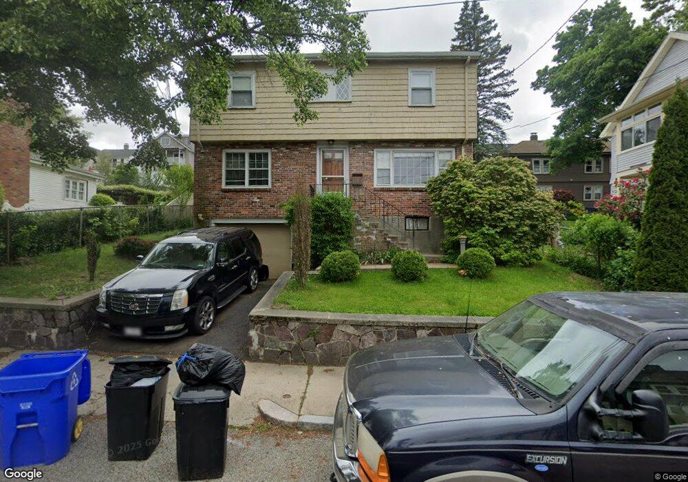
7 Glencliff Rd Roslindale, MA 02131
Roslindale NeighborhoodEstimated Value: $714,147 - $750,000
4
Beds
2
Baths
1,606
Sq Ft
$460/Sq Ft
Est. Value
About This Home
This home is located at 7 Glencliff Rd, Roslindale, MA 02131 and is currently estimated at $738,037, approximately $459 per square foot. 7 Glencliff Rd is a home located in Suffolk County with nearby schools including Brooke Charter School Roslindale, Sacred Heart STEM School, and St. Clare High School.
Ownership History
Date
Name
Owned For
Owner Type
Purchase Details
Closed on
Sep 15, 2009
Sold by
Obrien George G
Bought by
Stots Jesse and Harris-Stots Victoria
Current Estimated Value
Home Financials for this Owner
Home Financials are based on the most recent Mortgage that was taken out on this home.
Original Mortgage
$246,400
Outstanding Balance
$162,531
Interest Rate
5.36%
Mortgage Type
Purchase Money Mortgage
Estimated Equity
$575,506
Create a Home Valuation Report for This Property
The Home Valuation Report is an in-depth analysis detailing your home's value as well as a comparison with similar homes in the area
Home Values in the Area
Average Home Value in this Area
Purchase History
| Date | Buyer | Sale Price | Title Company |
|---|---|---|---|
| Stots Jesse | $320,000 | -- |
Source: Public Records
Mortgage History
| Date | Status | Borrower | Loan Amount |
|---|---|---|---|
| Open | Stots Jesse | $246,400 |
Source: Public Records
Tax History
| Year | Tax Paid | Tax Assessment Tax Assessment Total Assessment is a certain percentage of the fair market value that is determined by local assessors to be the total taxable value of land and additions on the property. | Land | Improvement |
|---|---|---|---|---|
| 2025 | $6,657 | $574,900 | $226,600 | $348,300 |
| 2024 | $5,999 | $550,400 | $200,300 | $350,100 |
| 2023 | $5,575 | $519,100 | $188,900 | $330,200 |
| 2022 | $5,134 | $471,900 | $171,800 | $300,100 |
| 2021 | $4,717 | $442,100 | $165,100 | $277,000 |
| 2020 | $4,507 | $426,800 | $151,000 | $275,800 |
| 2019 | $4,088 | $387,900 | $122,000 | $265,900 |
| 2018 | $3,870 | $369,300 | $122,000 | $247,300 |
| 2017 | $3,687 | $348,200 | $122,000 | $226,200 |
| 2016 | $3,793 | $344,800 | $122,000 | $222,800 |
| 2015 | $3,689 | $304,600 | $116,000 | $188,600 |
| 2014 | $3,578 | $284,400 | $116,000 | $168,400 |
Source: Public Records
Map
Nearby Homes
- 49 Dale St
- 76 Dale St
- 551 Poplar St
- 498 Beech St
- 15 Highfield Rd
- 86 Cornell St Unit 2
- 89 Glendower Rd
- 124 Glendower Rd Unit 2
- 103 Whitford St
- 15 Beechmont Terrace
- 5 7 Hemman St
- 115 Windham Rd
- 142 Metropolitan Ave Unit 2
- 142 Metropolitan Ave Unit 1
- 142 Metropolitan Ave
- 1 Beechmont Terrace
- 766 Hyde Park Ave
- 174 Cornell St
- 800 Hyde Park Ave Unit 3
- 895 Hyde Park Ave Unit 2
- 11 Glencliff Rd
- 500 Poplar St Unit 502
- 508 Poplar St Unit 510
- 510 Poplar St Unit 2
- 592 Beech St Unit 594
- 494 Poplar St Unit 496
- 588 Beech St
- 588 Beech St Unit 1
- 588 Beech St Unit 2
- 10 Glencliff Rd
- 514 Poplar St Unit 2
- 514 Poplar St Unit 1
- 15 Glencliff Rd Unit 1
- 15 Glencliff Rd
- 516 Poplar St Unit 518
- 12 Glencliff Rd
- 598 Beech St
- 596 Beech St
- 598 Beech St Unit 2
- 596 Beech St Unit 598
Your Personal Tour Guide
Ask me questions while you tour the home.