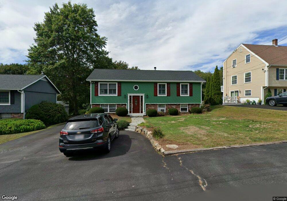
7 Goodwin Rd Gloucester, MA 01930
Estimated Value: $620,799 - $707,000
3
Beds
1
Bath
1,008
Sq Ft
$653/Sq Ft
Est. Value
About This Home
This home is located at 7 Goodwin Rd, Gloucester, MA 01930 and is currently estimated at $657,950, approximately $652 per square foot. 7 Goodwin Rd is a home located in Essex County with nearby schools including Beeman Memorial, Ralph B O'maley Middle School, and Gloucester High School.
Ownership History
Date
Name
Owned For
Owner Type
Purchase Details
Closed on
Jan 22, 2025
Sold by
Lechleiter John F and Lechleiter Josephine M
Bought by
Lechleiter Ft and Lechleiter
Current Estimated Value
Purchase Details
Closed on
May 20, 1983
Bought by
Lechleiter John F and Lechleiter J
Create a Home Valuation Report for This Property
The Home Valuation Report is an in-depth analysis detailing your home's value as well as a comparison with similar homes in the area
Purchase History
| Date | Buyer | Sale Price | Title Company |
|---|---|---|---|
| Lechleiter Ft | -- | None Available | |
| Lechleiter John F | $60,000 | -- |
Source: Public Records
Mortgage History
| Date | Status | Borrower | Loan Amount |
|---|---|---|---|
| Previous Owner | Lechleiter John F | $162,000 | |
| Previous Owner | Lechleiter John F | $134,000 | |
| Previous Owner | Lechleiter John F | $75,000 |
Source: Public Records
Tax History
| Year | Tax Paid | Tax Assessment Tax Assessment Total Assessment is a certain percentage of the fair market value that is determined by local assessors to be the total taxable value of land and additions on the property. | Land | Improvement |
|---|---|---|---|---|
| 2025 | $5,190 | $534,000 | $186,100 | $347,900 |
| 2024 | $5,324 | $547,200 | $177,200 | $370,000 |
| 2023 | $5,018 | $473,800 | $158,300 | $315,500 |
| 2022 | $4,677 | $398,700 | $137,700 | $261,000 |
| 2021 | $4,485 | $360,500 | $125,100 | $235,400 |
| 2020 | $4,198 | $340,500 | $125,100 | $215,400 |
| 2019 | $4,205 | $331,400 | $125,100 | $206,300 |
| 2018 | $3,953 | $305,700 | $125,100 | $180,600 |
| 2017 | $3,731 | $282,900 | $119,200 | $163,700 |
| 2016 | $3,720 | $273,300 | $124,300 | $149,000 |
| 2015 | $3,565 | $261,200 | $124,300 | $136,900 |
Source: Public Records
Map
Nearby Homes
- 3 Deacon Farm Ln
- 31 Echo Ave
- 2 Breezy Point Rd
- 13 Honeysuckle Rd
- 672 Washington St
- 13 Mystic Ave
- 8 Mystic Ave
- 98 Maplewood Ave
- 6 Monroe Ct
- 12 Arthur St
- 9 Cleveland Place
- 40 Sargent St
- 19 Trask St Unit 2
- 50 Warner St
- 113 Pleasant St
- 33 Maplewood Ave Unit 310
- 167 Atlantic St
- 178 Atlantic St
- 15 Mount Vernon St
- 226 Atlantic St
Your Personal Tour Guide
Ask me questions while you tour the home.