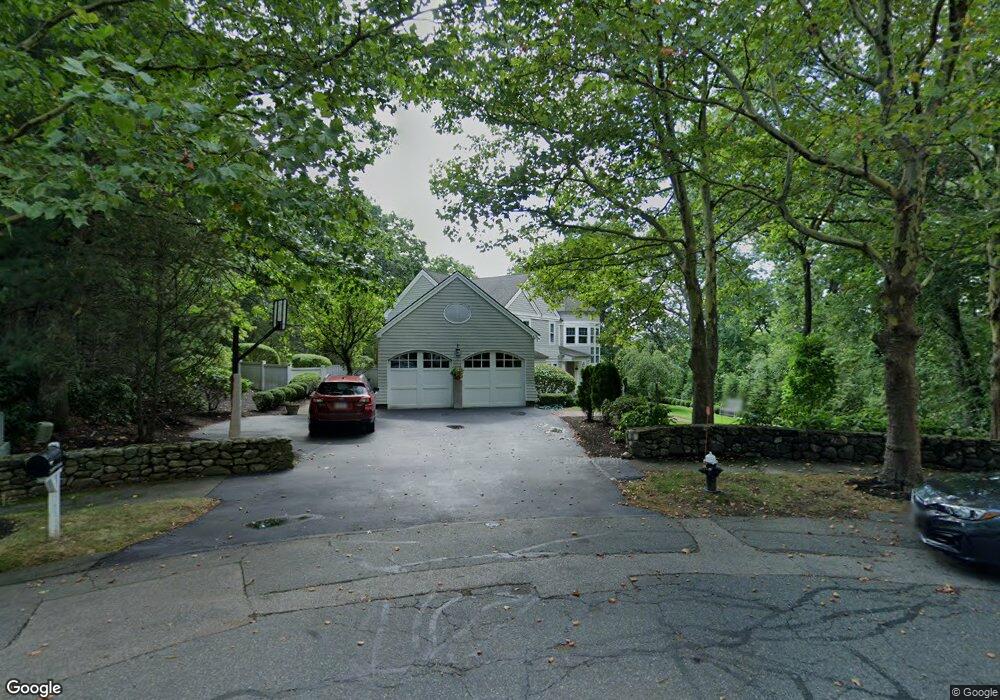
7 Hampton Rd Lexington, MA 02421
Five Fields NeighborhoodEstimated Value: $2,469,092 - $3,257,000
5
Beds
5
Baths
4,723
Sq Ft
$632/Sq Ft
Est. Value
About This Home
This home is located at 7 Hampton Rd, Lexington, MA 02421 and is currently estimated at $2,985,273, approximately $632 per square foot. 7 Hampton Rd is a home located in Middlesex County with nearby schools including Maria Hastings Elementary School, Jonas Clarke Middle School, and Lexington High School.
Ownership History
Date
Name
Owned For
Owner Type
Purchase Details
Closed on
Dec 29, 2022
Sold by
Kimball George J and Kimball Marilyn A
Bought by
Kimball Ft
Current Estimated Value
Purchase Details
Closed on
Jul 1, 2010
Sold by
Parshley Paul C and Parshley Catherine S
Bought by
Kimball George J and Kimball Marilyn A
Home Financials for this Owner
Home Financials are based on the most recent Mortgage that was taken out on this home.
Original Mortgage
$650,000
Interest Rate
4.88%
Mortgage Type
Purchase Money Mortgage
Purchase Details
Closed on
May 5, 1999
Sold by
Alessi Arleen G
Bought by
Parshley Catherine S and Parshley Paul C
Create a Home Valuation Report for This Property
The Home Valuation Report is an in-depth analysis detailing your home's value as well as a comparison with similar homes in the area
Home Values in the Area
Average Home Value in this Area
Purchase History
| Date | Buyer | Sale Price | Title Company |
|---|---|---|---|
| Kimball Ft | -- | None Available | |
| Kimball Ft | -- | None Available | |
| Kimball George J | $1,365,000 | -- | |
| Kimball George J | $1,365,000 | -- | |
| Parshley Catherine S | $871,000 | -- |
Source: Public Records
Mortgage History
| Date | Status | Borrower | Loan Amount |
|---|---|---|---|
| Previous Owner | Parshley Catherine S | $417,000 | |
| Previous Owner | Parshley Catherine S | $400,000 | |
| Previous Owner | Kimball George J | $650,000 |
Source: Public Records
Tax History
| Year | Tax Paid | Tax Assessment Tax Assessment Total Assessment is a certain percentage of the fair market value that is determined by local assessors to be the total taxable value of land and additions on the property. | Land | Improvement |
|---|---|---|---|---|
| 2025 | $28,533 | $2,333,000 | $960,000 | $1,373,000 |
| 2024 | $28,445 | $2,322,000 | $914,000 | $1,408,000 |
| 2023 | $26,728 | $2,056,000 | $831,000 | $1,225,000 |
| 2022 | $25,475 | $1,846,000 | $756,000 | $1,090,000 |
| 2021 | $26,564 | $1,846,000 | $750,000 | $1,096,000 |
| 2020 | $24,616 | $1,752,000 | $750,000 | $1,002,000 |
| 2019 | $23,891 | $1,692,000 | $714,000 | $978,000 |
| 2018 | $8,208 | $1,614,000 | $680,000 | $934,000 |
| 2017 | $22,503 | $1,553,000 | $648,000 | $905,000 |
| 2016 | $22,338 | $1,530,000 | $617,000 | $913,000 |
| 2015 | $21,280 | $1,432,000 | $561,000 | $871,000 |
| 2014 | $20,690 | $1,334,000 | $510,000 | $824,000 |
Source: Public Records
Map
Nearby Homes
- 353 Concord Ave
- 9 April Ln Unit 9
- 1105 Lexington St Unit 6-4
- 7 Field Rd
- 542 Concord Ave
- 14 Benjamin Rd
- 89 Hardy Pond Rd
- 34 Allen St
- 12 Wellington Lane Ave
- 170 Clocktower Dr Unit 103
- 44 Lakeview Terrace
- 86 Indian Rd
- 72 Grassland St
- 203 College Farm Rd
- 22 Fairbanks Rd
- 32 Moon Hill Rd
- 15 Bird Hill Rd
- 28 Hillcrest St
- 21 Lakeview Ave
- 3 Effie Place
- 7 Hampton Rd Unit 7
- 5 Hampton Rd
- 8 Hampton Rd
- 0 Concord Ave
- 6 Hampton Rd
- 3 Hampton Rd
- 416 Concord Ave
- 404 Concord Ave
- 430 Concord Ave
- 430 Concord Ave Unit 1
- 4 Hampton Rd
- 396 Concord Ave
- 426 Concord Ave
- 405 Concord Ave
- 2 Hampton Rd
- 2 Hampton Rd Unit 2
- 421 Concord Ave
- 382 Concord Ave
- 440 Concord Ave
- 389 Concord Ave
Your Personal Tour Guide
Ask me questions while you tour the home.