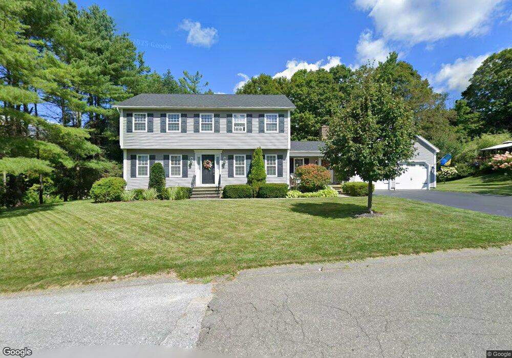
7 Hemlock Hill Dalton, MA 01226
Estimated Value: $569,000 - $607,000
4
Beds
3
Baths
3,593
Sq Ft
$164/Sq Ft
Est. Value
About This Home
This home is located at 7 Hemlock Hill, Dalton, MA 01226 and is currently estimated at $590,221, approximately $164 per square foot. 7 Hemlock Hill is a home located in Berkshire County with nearby schools including Wahconah Regional High School, St. Agnes Academy, and Sacred Heart School.
Ownership History
Date
Name
Owned For
Owner Type
Purchase Details
Closed on
Jun 9, 2025
Sold by
Strum Steven J and Strum Kathleen M
Bought by
Strum Brent W and Strum Kristin M
Current Estimated Value
Purchase Details
Closed on
Nov 21, 2003
Sold by
Daniels Jane R
Bought by
Sturm Steven J and Sturm Kathleen M
Purchase Details
Closed on
Oct 12, 1988
Sold by
Davis Richard D
Bought by
Daniels Walter T
Create a Home Valuation Report for This Property
The Home Valuation Report is an in-depth analysis detailing your home's value as well as a comparison with similar homes in the area
Home Values in the Area
Average Home Value in this Area
Purchase History
| Date | Buyer | Sale Price | Title Company |
|---|---|---|---|
| Strum Brent W | -- | None Available | |
| Strum Brent W | -- | None Available | |
| Sturm Steven J | $245,000 | -- | |
| Sturm Steven J | $245,000 | -- | |
| Daniels Walter T | $205,000 | -- |
Source: Public Records
Mortgage History
| Date | Status | Borrower | Loan Amount |
|---|---|---|---|
| Previous Owner | Daniels Walter T | $71,783 | |
| Previous Owner | Daniels Walter T | $200,000 | |
| Previous Owner | Daniels Walter T | $74,000 |
Source: Public Records
Tax History Compared to Growth
Tax History
| Year | Tax Paid | Tax Assessment Tax Assessment Total Assessment is a certain percentage of the fair market value that is determined by local assessors to be the total taxable value of land and additions on the property. | Land | Improvement |
|---|---|---|---|---|
| 2025 | $8,833 | $487,200 | $87,700 | $399,500 |
| 2024 | $8,276 | $454,700 | $81,800 | $372,900 |
| 2023 | $6,977 | $390,700 | $74,500 | $316,200 |
| 2022 | $6,977 | $336,400 | $74,500 | $261,900 |
| 2021 | $7,083 | $329,300 | $69,700 | $259,600 |
| 2020 | $6,379 | $314,400 | $69,700 | $244,700 |
| 2019 | $6,095 | $312,900 | $67,300 | $245,600 |
| 2018 | $6,041 | $303,400 | $67,300 | $236,100 |
| 2017 | $6,029 | $303,400 | $67,300 | $236,100 |
| 2016 | $5,956 | $303,400 | $67,300 | $236,100 |
| 2015 | $5,829 | $299,400 | $67,300 | $232,100 |
Source: Public Records
Map
Nearby Homes
- 48 Elaine Ave
- 1 Pondview Dr Unit C3
- 127 Barton Hill Rd
- 0 Crane Ave
- 44 Eleanor Rd
- 1994 East St
- 9 Crane Ave
- 13 Pleasantview Dr
- 387 Dalton Division Rd
- 39 Highlawn Dr
- 29 John St
- 144 Kittredge Rd
- 82 Williamsburg Terrace
- 67 Oak Street Extension
- 196 Park Ave
- 164 Depot St
- 0 Dalton Division Rd
- 45 Patricia Ave
- 750 Main St
- 774 Main St