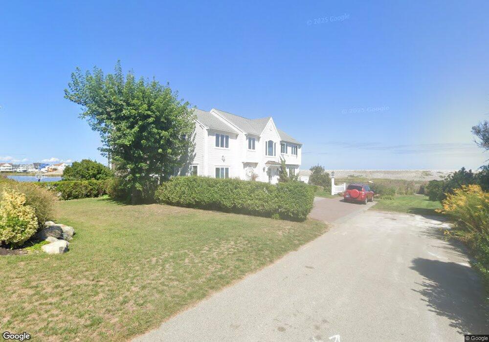
7 Jawl Ave Scituate, MA 02066
Estimated Value: $1,158,000 - $1,634,000
3
Beds
3
Baths
2,282
Sq Ft
$640/Sq Ft
Est. Value
About This Home
This home is located at 7 Jawl Ave, Scituate, MA 02066 and is currently estimated at $1,459,426, approximately $639 per square foot. 7 Jawl Ave is a home located in Plymouth County with nearby schools including Wampatuck Elementary School, Lester J. Gates Middle School, and Scituate High School.
Ownership History
Date
Name
Owned For
Owner Type
Purchase Details
Closed on
Jul 23, 2009
Sold by
Haider Syed H
Bought by
Caine James T and Caine Christine M
Current Estimated Value
Home Financials for this Owner
Home Financials are based on the most recent Mortgage that was taken out on this home.
Original Mortgage
$290,000
Outstanding Balance
$191,852
Interest Rate
5.58%
Mortgage Type
Purchase Money Mortgage
Estimated Equity
$1,267,574
Purchase Details
Closed on
Apr 29, 2008
Sold by
Nichols Jacqueline D
Bought by
Haider Syed H
Home Financials for this Owner
Home Financials are based on the most recent Mortgage that was taken out on this home.
Original Mortgage
$420,000
Interest Rate
6.22%
Mortgage Type
Purchase Money Mortgage
Create a Home Valuation Report for This Property
The Home Valuation Report is an in-depth analysis detailing your home's value as well as a comparison with similar homes in the area
Home Values in the Area
Average Home Value in this Area
Purchase History
| Date | Buyer | Sale Price | Title Company |
|---|---|---|---|
| Caine James T | $590,000 | -- | |
| Haider Syed H | $225,000 | -- |
Source: Public Records
Mortgage History
| Date | Status | Borrower | Loan Amount |
|---|---|---|---|
| Open | Haider Syed H | $290,000 | |
| Previous Owner | Haider Syed H | $420,000 | |
| Previous Owner | Haider Syed H | $60,000 | |
| Previous Owner | Haider Syed H | $60,000 |
Source: Public Records
Tax History Compared to Growth
Tax History
| Year | Tax Paid | Tax Assessment Tax Assessment Total Assessment is a certain percentage of the fair market value that is determined by local assessors to be the total taxable value of land and additions on the property. | Land | Improvement |
|---|---|---|---|---|
| 2025 | $12,188 | $1,220,000 | $653,000 | $567,000 |
| 2024 | $11,982 | $1,156,600 | $593,700 | $562,900 |
| 2023 | $11,219 | $1,068,400 | $539,700 | $528,700 |
| 2022 | $11,219 | $889,000 | $440,400 | $448,600 |
| 2021 | $10,948 | $821,300 | $419,400 | $401,900 |
| 2020 | $10,674 | $790,700 | $403,200 | $387,500 |
| 2019 | $10,512 | $765,100 | $395,300 | $369,800 |
| 2018 | $9,836 | $705,100 | $368,100 | $337,000 |
| 2017 | $8,894 | $631,200 | $318,300 | $312,900 |
| 2016 | $8,785 | $621,300 | $308,400 | $312,900 |
| 2015 | $8,009 | $611,400 | $298,500 | $312,900 |
Source: Public Records
Map
Nearby Homes
- 29 Country Club Cir
- 378 Tilden Rd
- 27 Ann Vinal Rd
- 17 Bradford Ave
- 2 Windward Ln
- 59 Captain Peirce Rd
- 30 Irving Rd
- 209 Hatherly Rd
- 112 Hollett St
- 54 Woodland Rd
- 22 Kings Way
- 16 3 Ring Rd
- 7 Border St
- 10 Baileys Causeway
- 10 Benjamin Ln Unit 10
- 14 Aberdeen Dr
- 26 Mordecai Lincoln Rd
- 6 Tilden Ave
- 23 Oceanside Dr
- 105 Turner Rd