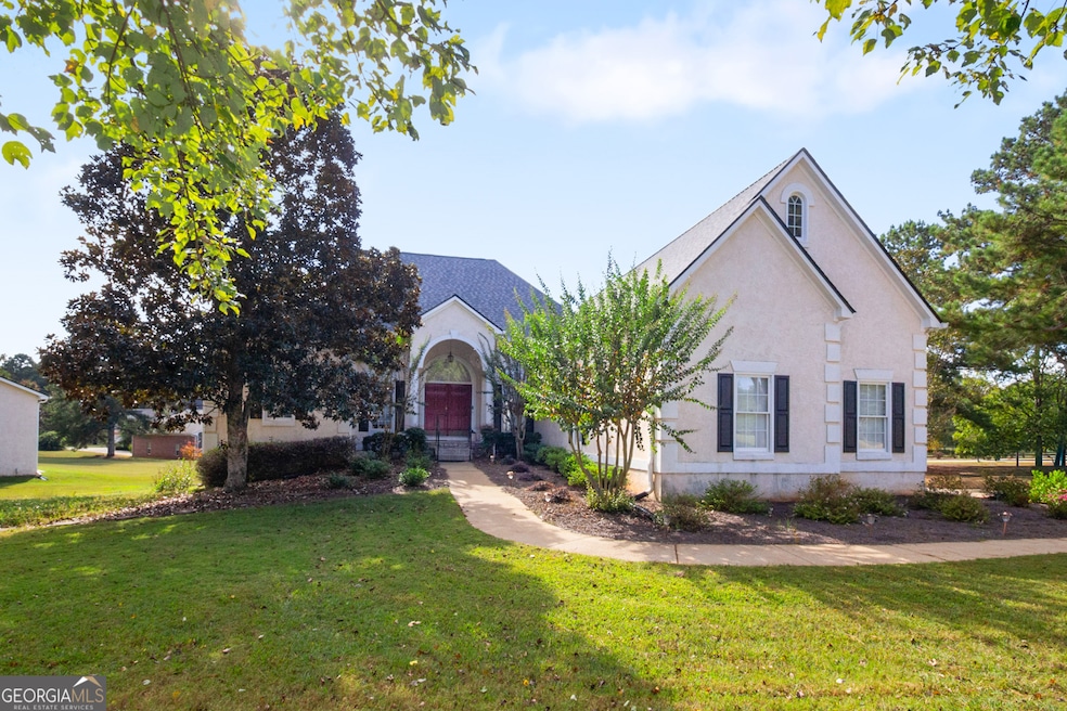
7 Mallard Ln Locust Grove, GA 30248
Estimated payment $4,284/month
Highlights
- Airport or Runway
- Dining Room Seats More Than Twelve
- Traditional Architecture
- 1.59 Acre Lot
- Clubhouse
- Wood Flooring
About This Home
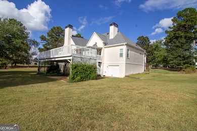
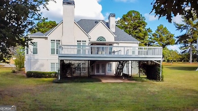
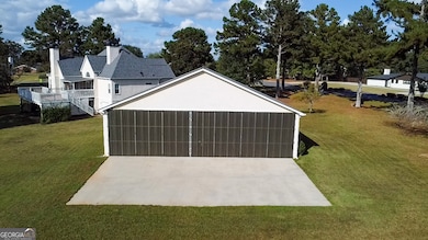
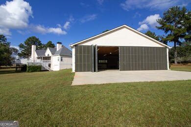
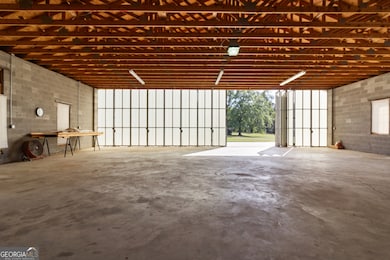
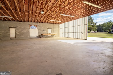
Fly-In Ready Home with Detached Hangar in Mallard's Landing! Welcome to your private aviation retreat in Georgia's premier fly-in community. This home spans 2,459 square feet and is perfectly tailored for pilots and aviation enthusiasts. Situated on a taxiway-access lot, this property is located approximately 2000 feet to the 4500-foot reinforced turf runway! This property features not one, but two hangars: an attached T-hangar and a spacious 40' x 50' detached hangar. The detached hanger has 12 foot high walls and a 48 foot door. For the beautiful home, step inside to a welcoming foyer that opens to the large family room with a fireplace and a formal dining room. The kitchen has granite countertops, lots of cabinets, a breakfast area, and an inviting keeping room! For the owner, the spacious master suite offers a sitting area and large private bath. The full daylight basement is partially finished with a full bath, and is pre-studded for two additional bedrooms, a kitchen, living area, and a third fireplace offering potential for guest quarters or multi-generational living. In addition, you'll find a workshop area with a roll up door and safe room. Additional features include a 3-car garage. Whether you're taxiing home after a flight or enjoying a quiet evening this exceptional home offers the perfect blend of lifestyle, luxury, and location. Schedule your private showing today!
Home Details
Home Type
- Single Family
Est. Annual Taxes
- $9,028
Year Built
- Built in 1994
Lot Details
- 1.59 Acre Lot
- Corner Lot
- Level Lot
HOA Fees
- $100 Monthly HOA Fees
Home Design
- Traditional Architecture
- Composition Roof
- Stucco
Interior Spaces
- 2,459 Sq Ft Home
- 1-Story Property
- 2 Fireplaces
- Entrance Foyer
- Family Room
- Dining Room Seats More Than Twelve
- Formal Dining Room
- Keeping Room
- Laundry in Hall
Kitchen
- Breakfast Area or Nook
- Double Oven
- Cooktop
- Microwave
- Dishwasher
Flooring
- Wood
- Carpet
Bedrooms and Bathrooms
- 3 Main Level Bedrooms
Unfinished Basement
- Basement Fills Entire Space Under The House
- Interior and Exterior Basement Entry
- Boat door in Basement
- Finished Basement Bathroom
- Natural lighting in basement
Parking
- Garage
- Garage Door Opener
Schools
- Bethlehem Elementary School
- Luella Middle School
- Luella High School
Utilities
- Cooling Available
- Heating System Uses Natural Gas
- Septic Tank
Community Details
Overview
- Association fees include ground maintenance, swimming
- Mallards Landing Subdivision
Amenities
- Airport or Runway
- Clubhouse
Recreation
- Community Playground
- Community Pool
Map
Home Values in the Area
Average Home Value in this Area
Tax History
| Year | Tax Paid | Tax Assessment Tax Assessment Total Assessment is a certain percentage of the fair market value that is determined by local assessors to be the total taxable value of land and additions on the property. | Land | Improvement |
|---|---|---|---|---|
| 2025 | $2,103 | $229,720 | $30,000 | $199,720 |
| 2024 | $2,103 | $216,320 | $30,000 | $186,320 |
| 2023 | $1,879 | $212,120 | $30,000 | $182,120 |
| 2022 | $2,056 | $178,960 | $30,000 | $148,960 |
| 2021 | $2,089 | $175,800 | $30,000 | $145,800 |
| 2020 | $2,069 | $164,120 | $30,000 | $134,120 |
| 2019 | $2,085 | $165,360 | $30,000 | $135,360 |
| 2018 | $2,016 | $149,120 | $26,000 | $123,120 |
| 2016 | $1,617 | $122,040 | $26,000 | $96,040 |
| 2015 | -- | $121,760 | $26,000 | $95,760 |
| 2014 | $1,602 | $110,880 | $24,000 | $86,880 |
Property History
| Date | Event | Price | List to Sale | Price per Sq Ft |
|---|---|---|---|---|
| 11/19/2025 11/19/25 | Price Changed | $649,900 | -7.1% | $264 / Sq Ft |
| 10/09/2025 10/09/25 | For Sale | $699,900 | -- | $285 / Sq Ft |
Purchase History
| Date | Type | Sale Price | Title Company |
|---|---|---|---|
| Deed | $280,000 | -- | |
| Deed | $245,000 | -- |
Mortgage History
| Date | Status | Loan Amount | Loan Type |
|---|---|---|---|
| Open | $120,000 | New Conventional | |
| Previous Owner | $214,600 | New Conventional |
Source: Georgia MLS
MLS Number: 10621656
APN: 097A-01-007-000
Disclaimer: Certain information contained herein is derived from information provided by parties other than Homes.com. All information provided is deemed reliable, but is not guaranteed to be accurate and should be independently verified.
![]() The data relating to real estate for sale on this web site comes in part from the Broker Reciprocity Program of Georgia MLS. Real estate listings held by brokerage firms other than Redfin are marked with the Broker Reciprocity logo and detailed information about them includes the name of the listing brokers. Information deemed reliable but not guaranteed. Copyright 2025 Georgia MLS. All rights reserved.
The data relating to real estate for sale on this web site comes in part from the Broker Reciprocity Program of Georgia MLS. Real estate listings held by brokerage firms other than Redfin are marked with the Broker Reciprocity logo and detailed information about them includes the name of the listing brokers. Information deemed reliable but not guaranteed. Copyright 2025 Georgia MLS. All rights reserved.
- 0 Mallard Ln Unit LOT 51
- Meridian II Plan at Kingston
- Wagener Plan at Kingston
- 1004 Linford Ct
- Lauren II Plan at Kingston
- 242 Linford Dr
- Wynwood Plan at Kingston
- Clarity Plan at Kingston
- Henry II Plan at Kingston
- 512 Dolce Rd
- Rosemary II Plan at Kingston
- 238 Linford Dr
- 211 Linford Dr
- Rainier Plan at Kingston
- 302 Linford Dr
- 51 Mallard Ln
- 1615 Avery Dr
- 436 Lothbury Ave
- 3612 Bill Gardner Pkwy
- 335 Canvasback Trail
- 1024 Eagles Brooke Dr
- 1224 Nottley Dr
- 256 Gilliam Ct
- 609 Alyssa Ct
- 158 Fresh Laurel Ln
- 9033 Aldbury Dr
- 489 Glouchester Dr
- 905 Vandiver Ct
- 708 Percevil Point
- 128 Rendition Dr
- 2405 Langstan Ct
- 310 the Gables Dr
- 2812 Harcourt Dr
- 229 Klinetop Dr
- 233 Klinetop Dr
- 2520 Mockingbird Ln
- 276 Hawken Trail
- 621 Everlasting Way
- 485 Cathedral Dr
- 153 Lossie Ln
