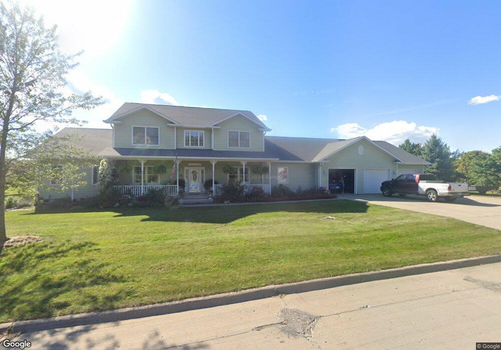
7 Pinehurst Cir Ottumwa, IA 52501
Estimated Value: $464,000 - $589,292
5
Beds
5
Baths
4,701
Sq Ft
$109/Sq Ft
Est. Value
About This Home
This home is located at 7 Pinehurst Cir, Ottumwa, IA 52501 and is currently estimated at $510,097, approximately $108 per square foot. 7 Pinehurst Cir is a home located in Wapello County with nearby schools including Eisenhower Elementary School, Evans Middle School, and Ottumwa High School.
Ownership History
Date
Name
Owned For
Owner Type
Purchase Details
Closed on
Feb 27, 2024
Sold by
Baldridge Denise
Bought by
Stanley Paul And Janenne L Wellman Trust and Wellman
Current Estimated Value
Purchase Details
Closed on
Sep 21, 2023
Sold by
Wellman Stanley P and Wellman Janenne L
Bought by
Stanley And Janenne Wellman Revocable Trust and Wellman
Purchase Details
Closed on
Jul 8, 2005
Sold by
Marack Inc
Bought by
Wellman Stanley P and Wellman Janenne
Create a Home Valuation Report for This Property
The Home Valuation Report is an in-depth analysis detailing your home's value as well as a comparison with similar homes in the area
Home Values in the Area
Average Home Value in this Area
Purchase History
| Date | Buyer | Sale Price | Title Company |
|---|---|---|---|
| Stanley Paul And Janenne L Wellman Trust | $25,000 | None Listed On Document | |
| Stanley And Janenne Wellman Revocable Trust | -- | None Listed On Document | |
| Stanley And Janenne Wellman Revocable Trust | -- | None Listed On Document | |
| Wellman Stanley P | $28,000 | None Available |
Source: Public Records
Tax History Compared to Growth
Tax History
| Year | Tax Paid | Tax Assessment Tax Assessment Total Assessment is a certain percentage of the fair market value that is determined by local assessors to be the total taxable value of land and additions on the property. | Land | Improvement |
|---|---|---|---|---|
| 2025 | $12,860 | $666,110 | $47,910 | $618,200 |
| 2024 | $12,860 | $616,970 | $47,910 | $569,060 |
| 2023 | $11,484 | $616,850 | $47,910 | $568,940 |
| 2022 | $11,586 | $489,510 | $47,910 | $441,600 |
| 2021 | $11,798 | $464,700 | $47,910 | $416,790 |
| 2020 | $10,502 | $417,240 | $47,910 | $369,330 |
| 2019 | $10,730 | $417,240 | $0 | $0 |
| 2018 | $10,410 | $417,240 | $0 | $0 |
| 2017 | $10,410 | $417,240 | $0 | $0 |
| 2016 | $10,110 | $413,177 | $0 | $0 |
| 2015 | $10,124 | $413,177 | $0 | $0 |
| 2014 | -- | $413,177 | $0 | $0 |
Source: Public Records
Map
Nearby Homes
- 32 Pinehurst Cir
- 34 Pinehurst Cir
- 0 150th Unit 6314578
- 11995 Rutledge Rd
- 10 Bell Dr
- 74 Schwartz Dr
- 627 Edwards Dr
- 2620 Marilyn Rd
- 0 E Rochester Rd
- 307 E Rochester Rd
- 11652 Rutledge Rd
- 2633 Clearview St
- 463 E Rochester Rd
- 2540 Kenwood St
- 211 Elmdale Ave
- 444 Crestview Ave
- 11994 118th Ave
- 2438 N Jefferson St
- 45 Brookwood Ct
- 418 Carter Ave
- 6 Sawgrass Trail
- 9 Pinehurst Cir
- 5 Pinehurst Cir
- 8 Pinehurst Cir
- 4 Sawgrass Trail
- 10 Pinehurst Cir
- 40 Pinehurst Cir
- 13460 Angle Rd
- 15 Pinehurst Cir
- 12 Pinehurst Cir
- 3 Pinehurst Cir
- 5 Sawgrass Trail
- 38 Pinehurst Cir
- 2 Sawgrass Trail
- 14 Pinehurst Cir
- 1 Sawgrass Trail
- 41 Pinehurst Cir
- 43 Pinehurst Cir
- 18 Pinehurst Cir
- 30 Pinehurst Cir