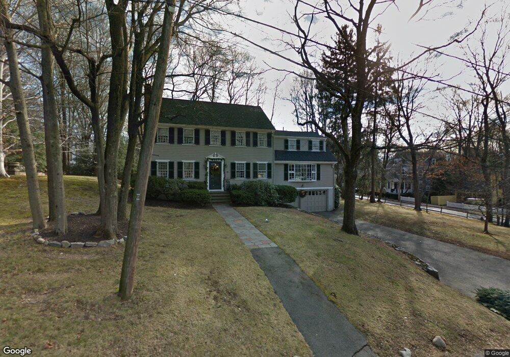
7 W Side Rd Milton, MA 02186
Columbine Cliffs NeighborhoodEstimated Value: $1,412,000 - $1,541,000
4
Beds
3
Baths
2,345
Sq Ft
$626/Sq Ft
Est. Value
About This Home
This home is located at 7 W Side Rd, Milton, MA 02186 and is currently estimated at $1,467,190, approximately $625 per square foot. 7 W Side Rd is a home located in Norfolk County with nearby schools including Milton High School, Conservatory Lab Upper School, and Saint John Paul II Catholic Academy.
Ownership History
Date
Name
Owned For
Owner Type
Purchase Details
Closed on
Nov 3, 2014
Sold by
Needham W P and Needham Virginia L
Bought by
Mccarthy Kevin M and Norcott Catherine R
Current Estimated Value
Purchase Details
Closed on
Nov 16, 1976
Bought by
Needham W Paul and Lee Virginia
Create a Home Valuation Report for This Property
The Home Valuation Report is an in-depth analysis detailing your home's value as well as a comparison with similar homes in the area
Home Values in the Area
Average Home Value in this Area
Purchase History
| Date | Buyer | Sale Price | Title Company |
|---|---|---|---|
| Mccarthy Kevin M | -- | -- | |
| Needham W P | -- | -- | |
| Needham W Paul | -- | -- |
Source: Public Records
Tax History
| Year | Tax Paid | Tax Assessment Tax Assessment Total Assessment is a certain percentage of the fair market value that is determined by local assessors to be the total taxable value of land and additions on the property. | Land | Improvement |
|---|---|---|---|---|
| 2025 | $13,503 | $1,217,600 | $665,300 | $552,300 |
| 2024 | $12,951 | $1,186,000 | $633,700 | $552,300 |
| 2023 | $12,688 | $1,113,000 | $603,400 | $509,600 |
| 2022 | $12,466 | $999,700 | $603,400 | $396,300 |
| 2021 | $12,178 | $927,500 | $550,100 | $377,400 |
| 2020 | $12,061 | $919,300 | $550,000 | $369,300 |
| 2019 | $11,764 | $892,600 | $534,000 | $358,600 |
| 2018 | $11,029 | $798,600 | $445,000 | $353,600 |
| 2017 | $10,315 | $760,700 | $423,800 | $336,900 |
| 2016 | $10,236 | $758,200 | $428,800 | $329,400 |
| 2015 | $10,380 | $744,600 | $415,600 | $329,000 |
Source: Public Records
Map
Nearby Homes
- 1241-1255 Adams St Unit F213
- 1241-1255 Adams St Unit B302
- 1245 Adams St Unit B503
- 88 Wharf St Unit 105
- 14 Avondale St
- 67 Idaho St
- 35 Standard St
- 260 Canton Ave
- 259 Central Ave
- 85 Forbes Rd
- 30 Pleasant Hill Ave Unit 32
- 23 Maryknoll St
- 14 Valley Rd
- 44 Allen Cir
- 2089 Dorchester Ave Unit 1
- 27-29 Brookvale St
- 424 Brook Rd
- 56 Fairmount St Unit 2
- 20 Fairmount St
- 2 Ogden St Unit 1
Your Personal Tour Guide
Ask me questions while you tour the home.