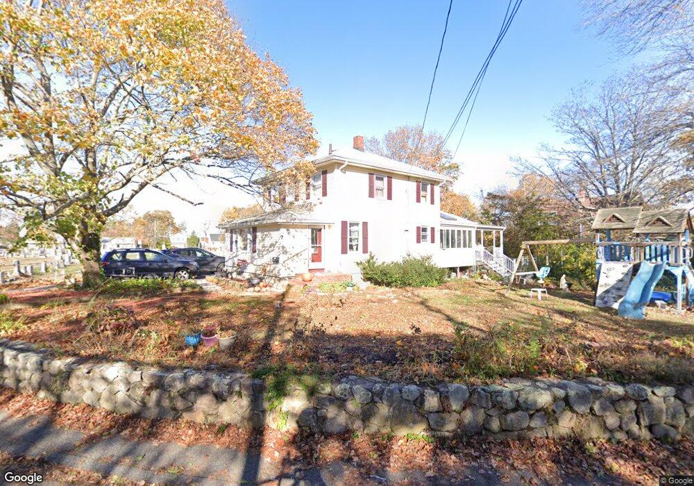
7 Wesley St Gloucester, MA 01930
Riverview NeighborhoodEstimated Value: $659,000 - $888,000
4
Beds
2
Baths
1,481
Sq Ft
$519/Sq Ft
Est. Value
About This Home
This home is located at 7 Wesley St, Gloucester, MA 01930 and is currently estimated at $768,093, approximately $518 per square foot. 7 Wesley St is a home located in Essex County with nearby schools including Beeman Memorial, Ralph B O'maley Middle School, and Gloucester High School.
Ownership History
Date
Name
Owned For
Owner Type
Purchase Details
Closed on
Oct 29, 2019
Sold by
Oleary Kathleen and Oleary Timothy J
Bought by
Kathleen Oleary Lt
Current Estimated Value
Purchase Details
Closed on
May 5, 1995
Sold by
Peterson Lawrence N and Peterson Marcia F
Bought by
Oleary Ronald J and Oleary Kathleen
Home Financials for this Owner
Home Financials are based on the most recent Mortgage that was taken out on this home.
Original Mortgage
$80,000
Interest Rate
8.36%
Mortgage Type
Purchase Money Mortgage
Create a Home Valuation Report for This Property
The Home Valuation Report is an in-depth analysis detailing your home's value as well as a comparison with similar homes in the area
Home Values in the Area
Average Home Value in this Area
Purchase History
| Date | Buyer | Sale Price | Title Company |
|---|---|---|---|
| Kathleen Oleary Lt | -- | -- | |
| Oleary Ronald J | $160,000 | -- |
Source: Public Records
Mortgage History
| Date | Status | Borrower | Loan Amount |
|---|---|---|---|
| Previous Owner | Oleary Ronald J | $30,000 | |
| Previous Owner | Oleary Ronald J | $76,000 | |
| Previous Owner | Oleary Ronald J | $71,000 | |
| Previous Owner | Oleary Ronald J | $80,000 |
Source: Public Records
Tax History
| Year | Tax Paid | Tax Assessment Tax Assessment Total Assessment is a certain percentage of the fair market value that is determined by local assessors to be the total taxable value of land and additions on the property. | Land | Improvement |
|---|---|---|---|---|
| 2025 | $6,114 | $629,000 | $229,900 | $399,100 |
| 2024 | $6,014 | $618,100 | $219,000 | $399,100 |
| 2023 | $5,761 | $544,000 | $195,500 | $348,500 |
| 2022 | $5,528 | $471,300 | $166,200 | $305,100 |
| 2021 | $5,333 | $428,700 | $151,100 | $277,600 |
| 2020 | $5,260 | $426,600 | $151,100 | $275,500 |
| 2019 | $5,040 | $397,200 | $151,100 | $246,100 |
| 2018 | $4,863 | $376,100 | $151,100 | $225,000 |
| 2017 | $4,700 | $356,300 | $143,900 | $212,400 |
| 2016 | $4,548 | $334,200 | $144,500 | $189,700 |
| 2015 | $4,361 | $319,500 | $144,500 | $175,000 |
Source: Public Records
Map
Nearby Homes
- 13 Honeysuckle Rd
- 3 Deacon Farm Ln
- 31 Echo Ave
- 2 Breezy Point Rd
- 13 Mystic Ave
- 8 Mystic Ave
- 6 Monroe Ct
- 98 Maplewood Ave
- 672 Washington St
- 9 Cleveland Place
- 12 Arthur St
- 167 Atlantic St
- 178 Atlantic St
- 40 Sargent St
- 15 Harvard St
- 145 Essex Ave Unit 402
- 33 Maplewood Ave Unit 310
- 19 Trask St Unit 2
- 113 Pleasant St
- 50 Warner St
Your Personal Tour Guide
Ask me questions while you tour the home.