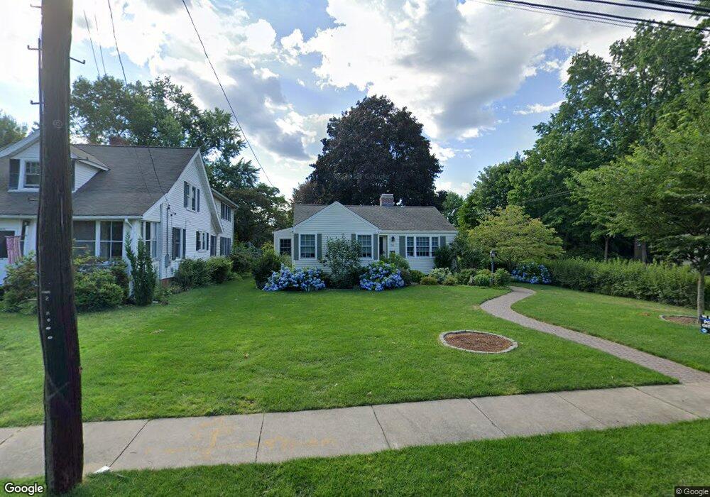
70 Main St Wethersfield, CT 06109
Estimated Value: $385,000 - $496,651
3
Beds
3
Baths
1,522
Sq Ft
$285/Sq Ft
Est. Value
About This Home
This home is located at 70 Main St, Wethersfield, CT 06109 and is currently estimated at $433,913, approximately $285 per square foot. 70 Main St is a home located in Hartford County with nearby schools including Alfred W. Hanmer School, Silas Deane Middle School, and Wethersfield High School.
Ownership History
Date
Name
Owned For
Owner Type
Purchase Details
Closed on
Jan 7, 2020
Sold by
Gove Matthew
Bought by
Gove Margaret A
Current Estimated Value
Purchase Details
Closed on
Aug 31, 2012
Sold by
Gove Margaret A
Bought by
Gove Matthew and Gove Margaret A
Purchase Details
Closed on
Jul 12, 2010
Sold by
Gove Matthew and Grove Margaret A
Bought by
Grove Margaret A
Purchase Details
Closed on
Nov 1, 2006
Sold by
Cardone Cheryl L and Cardone Francis S
Bought by
Gove Matthew S
Purchase Details
Closed on
Dec 15, 1993
Sold by
Cardone Samuel and Cardone Israele
Bought by
Cardone Cheryl L and Cardone Francis S
Create a Home Valuation Report for This Property
The Home Valuation Report is an in-depth analysis detailing your home's value as well as a comparison with similar homes in the area
Home Values in the Area
Average Home Value in this Area
Purchase History
| Date | Buyer | Sale Price | Title Company |
|---|---|---|---|
| Gove Margaret A | -- | None Available | |
| Gove Matthew | -- | -- | |
| Grove Margaret A | -- | -- | |
| Gove Matthew S | $205,000 | -- | |
| Cardone Cheryl L | $70,000 | -- |
Source: Public Records
Mortgage History
| Date | Status | Borrower | Loan Amount |
|---|---|---|---|
| Previous Owner | Cardone Cheryl L | $41,170 | |
| Previous Owner | Cardone Cheryl L | $18,830 |
Source: Public Records
Tax History
| Year | Tax Paid | Tax Assessment Tax Assessment Total Assessment is a certain percentage of the fair market value that is determined by local assessors to be the total taxable value of land and additions on the property. | Land | Improvement |
|---|---|---|---|---|
| 2025 | $12,526 | $303,880 | $124,740 | $179,140 |
| 2024 | $8,107 | $187,570 | $87,500 | $100,070 |
| 2023 | $7,843 | $187,730 | $87,500 | $100,230 |
| 2022 | $7,712 | $187,730 | $87,500 | $100,230 |
| 2021 | $7,635 | $187,730 | $87,500 | $100,230 |
| 2020 | $7,639 | $187,730 | $87,500 | $100,230 |
| 2019 | $7,648 | $187,730 | $87,500 | $100,230 |
| 2018 | $7,177 | $176,000 | $85,100 | $90,900 |
| 2017 | $7,000 | $176,000 | $85,100 | $90,900 |
| 2016 | $6,783 | $176,000 | $85,100 | $90,900 |
| 2015 | $6,721 | $176,000 | $85,100 | $90,900 |
| 2014 | $6,466 | $176,000 | $85,100 | $90,900 |
Source: Public Records
Map
Nearby Homes
- 91 Somerset St
- 87 Somerset St
- 35 Stillwold Dr
- 147 Spring St
- 1 Fernwood St
- 108 Chamberlain Rd
- 131 Coleman Rd
- 317-319 Garden St
- 23 Hillcrest Ave
- 99 Maple St
- 493 Main St
- 18 Avalon Place
- 192 Wolcott Hill Rd
- 750 Wolcott Hill Rd
- 538 Main St
- 107 Harmund Place
- 31 Ox Yoke Dr
- 158 Dix Rd
- 38 Wheeler Rd
- 137 Dale Rd
- 76 Main St
- 62 Main St
- 82 Main St
- 18 Chesterfield Rd
- 58 Main St
- 17 Chesterfield Rd
- 88 Main St
- 22 Chesterfield Rd
- 54 Main St
- 3 Old Pepperidge Ln
- 21 Chesterfield Rd
- 28 Chesterfield Rd
- 36 Old Pepperidge Ln
- 51 Main St Unit 53
- 9 Old Pepperidge Ln
- 11 Oldham Rd
- 48 Main St
- 75 Main St
- 45 Garden St
- 41 Garden St
Your Personal Tour Guide
Ask me questions while you tour the home.