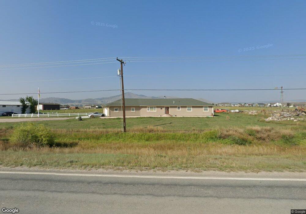
7000 N Montana Ave Helena, MT 59602
West Helena Valley NeighborhoodEstimated Value: $547,000 - $631,000
3
Beds
2
Baths
2,085
Sq Ft
$279/Sq Ft
Est. Value
About This Home
This home is located at 7000 N Montana Ave, Helena, MT 59602 and is currently estimated at $582,030, approximately $279 per square foot. 7000 N Montana Ave is a home located in Lewis and Clark County with nearby schools including Rossiter School and C.R. Anderson Middle School.
Ownership History
Date
Name
Owned For
Owner Type
Purchase Details
Closed on
Nov 30, 2023
Sold by
Ebert Mark Douglas
Bought by
Ebert Anna Renee and Ebert Markell Desiree
Current Estimated Value
Purchase Details
Closed on
Sep 28, 2023
Sold by
Ebert Faith M
Bought by
Ebert Mark D
Purchase Details
Closed on
Dec 1, 2021
Sold by
Douglas Ebert Mark
Bought by
Ebert Faith Michell and Ebert Mark Douglas
Purchase Details
Closed on
Oct 22, 2015
Sold by
Ebert Mary Lynn
Bought by
Ebert Mark D
Create a Home Valuation Report for This Property
The Home Valuation Report is an in-depth analysis detailing your home's value as well as a comparison with similar homes in the area
Home Values in the Area
Average Home Value in this Area
Purchase History
| Date | Buyer | Sale Price | Title Company |
|---|---|---|---|
| Ebert Anna Renee | -- | None Listed On Document | |
| Ebert Mark D | -- | None Listed On Document | |
| Ebert Faith Michell | -- | None Listed On Document | |
| Ebert Mark D | -- | None Available |
Source: Public Records
Tax History Compared to Growth
Tax History
| Year | Tax Paid | Tax Assessment Tax Assessment Total Assessment is a certain percentage of the fair market value that is determined by local assessors to be the total taxable value of land and additions on the property. | Land | Improvement |
|---|---|---|---|---|
| 2025 | $1,210 | $546,100 | $0 | $0 |
| 2024 | $3,870 | $471,200 | $0 | $0 |
| 2023 | $3,908 | $471,200 | $0 | $0 |
| 2022 | $2,999 | $305,200 | $0 | $0 |
| 2021 | $2,918 | $305,200 | $0 | $0 |
| 2020 | $2,984 | $299,100 | $0 | $0 |
| 2019 | $3,008 | $299,100 | $0 | $0 |
| 2018 | $3,214 | $316,800 | $0 | $0 |
| 2017 | $2,727 | $316,800 | $0 | $0 |
| 2016 | $2,296 | $253,050 | $0 | $0 |
| 2015 | $2,225 | $253,050 | $0 | $0 |
| 2014 | $1,938 | $120,811 | $0 | $0 |
Source: Public Records
Map
Nearby Homes
- 1370 Ponderosa Rd
- 1450 Ray Rd
- 6809 N Montana Ave
- 7190 Jenroe Dr
- 7175 Jenroe Dr
- 7120 Jenroe Dr
- 7567 Kingpost Loop
- 6320 Blackfoot Dr
- 7622 Kingpost Loop
- 7626 Roughsawn Dr
- 6299 N Montana Ave
- 1340 van Orsdel Rd
- 5527 Fireweed Loop
- 5534 Fireweed Loop
- 5533 Fireweed Loop
- 5515 Fireweed Loop
- 5514 Fireweed Loop
- 5503 Fireweed Loop
- 5539 Fireweed Loop
- 5508 Fireweed Loop
- 6980 N Montana Ave
- 1125 Tiller Ct
- 1148 Tiller Ct
- 1105 Tiller Ct
- 6960 N Montana Ave
- 1085 Tiller Ct
- 1120 Tiller Ct
- 7021 Garden Valley Dr
- 1045 Sower Ct
- 1142 Tiller Ct
- 7033 Garden Valley Dr
- 1260 Ponderosa Rd
- 7045 Garden Valley Dr
- 1100 Tiller Ct
- 1080 Tiller Ct
- 7050 Shady Dr
- 1055 Tiller Ct
- 7007 Garden Valley Dr
- 1197 John G Mine Rd
- 7007 Garden Valley Dr