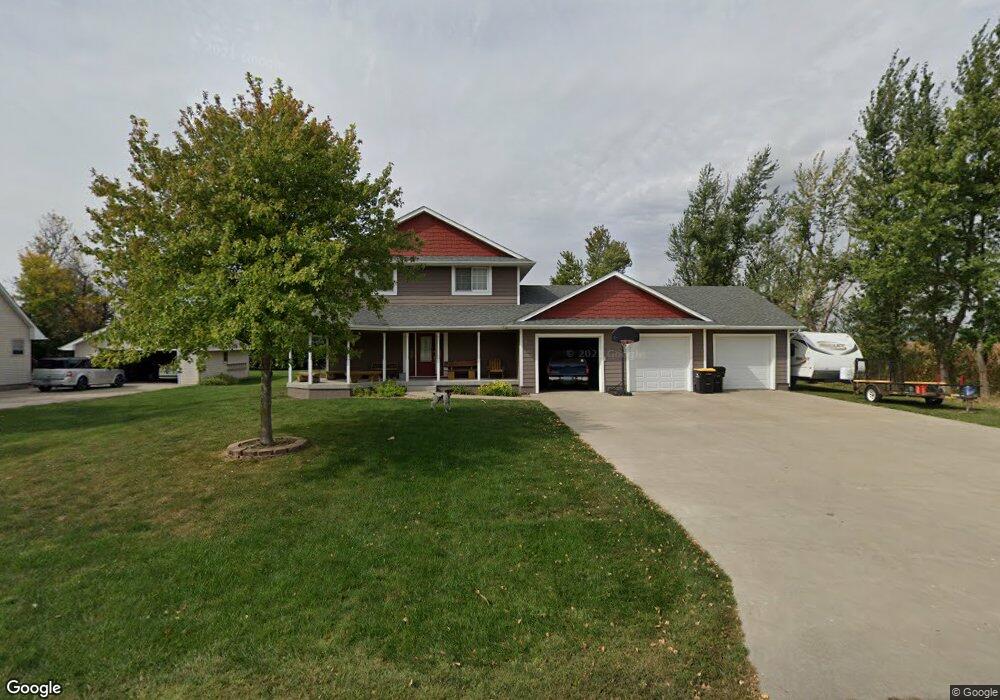
701 Carroll St Sheldahl, IA 50243
Estimated Value: $181,000 - $393,549
3
Beds
4
Baths
1,964
Sq Ft
$155/Sq Ft
Est. Value
About This Home
This home is located at 701 Carroll St, Sheldahl, IA 50243 and is currently estimated at $303,637, approximately $154 per square foot. 701 Carroll St is a home with nearby schools including North Polk West Elementary School, North Polk Central Elementary School, and North Polk Middle School.
Ownership History
Date
Name
Owned For
Owner Type
Purchase Details
Closed on
Aug 19, 2022
Sold by
Hanks and Beulah
Bought by
Coffman Paul D
Current Estimated Value
Purchase Details
Closed on
Oct 8, 2014
Sold by
Coffman Nichole Leona
Bought by
Coffman Paul Dean
Home Financials for this Owner
Home Financials are based on the most recent Mortgage that was taken out on this home.
Original Mortgage
$214,400
Interest Rate
4.08%
Mortgage Type
New Conventional
Purchase Details
Closed on
Jul 6, 2006
Sold by
Holland Marie
Bought by
Eichsen Evan and Eichsen Jennifer
Purchase Details
Closed on
Jul 21, 2005
Sold by
Frohling Henry M and Frohling Judith A
Bought by
Coffman Paul D and Coffman Nicole L
Create a Home Valuation Report for This Property
The Home Valuation Report is an in-depth analysis detailing your home's value as well as a comparison with similar homes in the area
Home Values in the Area
Average Home Value in this Area
Purchase History
| Date | Buyer | Sale Price | Title Company |
|---|---|---|---|
| Coffman Paul D | -- | None Listed On Document | |
| Coffman Paul Dean | -- | None Available | |
| Eichsen Evan | $79,000 | -- | |
| Coffman Paul D | $25,000 | None Available |
Source: Public Records
Mortgage History
| Date | Status | Borrower | Loan Amount |
|---|---|---|---|
| Previous Owner | Coffman Paul Dean | $214,400 |
Source: Public Records
Tax History Compared to Growth
Tax History
| Year | Tax Paid | Tax Assessment Tax Assessment Total Assessment is a certain percentage of the fair market value that is determined by local assessors to be the total taxable value of land and additions on the property. | Land | Improvement |
|---|---|---|---|---|
| 2025 | $5,318 | $388,500 | $80,500 | $308,000 |
| 2024 | $5,254 | $350,200 | $66,100 | $284,100 |
| 2023 | $4,714 | $350,200 | $66,100 | $284,100 |
| 2022 | $4,414 | $265,900 | $32,200 | $233,700 |
| 2021 | $4,254 | $265,900 | $32,200 | $233,700 |
| 2020 | $4,146 | $244,600 | $27,300 | $217,300 |
| 2019 | $4,146 | $244,600 | $27,300 | $217,300 |
| 2018 | $3,698 | $214,300 | $25,900 | $188,400 |
| 2017 | $3,698 | $214,300 | $25,900 | $188,400 |
| 2016 | $3,084 | $198,800 | $25,900 | $172,900 |
| 2015 | $3,084 | $198,800 | $25,900 | $172,900 |
| 2014 | $3,198 | $198,000 | $25,900 | $172,100 |
Source: Public Records
Map
Nearby Homes
- 106 Hubbell St
- 705 2nd St
- 1009 W Aspen Ridge Cir
- 1004 Redbud Dr
- 604 Marshall St
- 13223 NW 58th St
- 500 Tama St
- 108 3rd Ave
- 509 2nd Ave
- 107 Benton St
- 454 500th Ave
- 504 500th Ave
- 415 Sheffield Ave
- 455 Sheffield Ave
- 405 Sheffield Ave
- 445 Sheffield Ave
- 2057 340th St
- 13840 NW 16th St
- 935 Wild Oak Dr
- 108 S 4th Ave