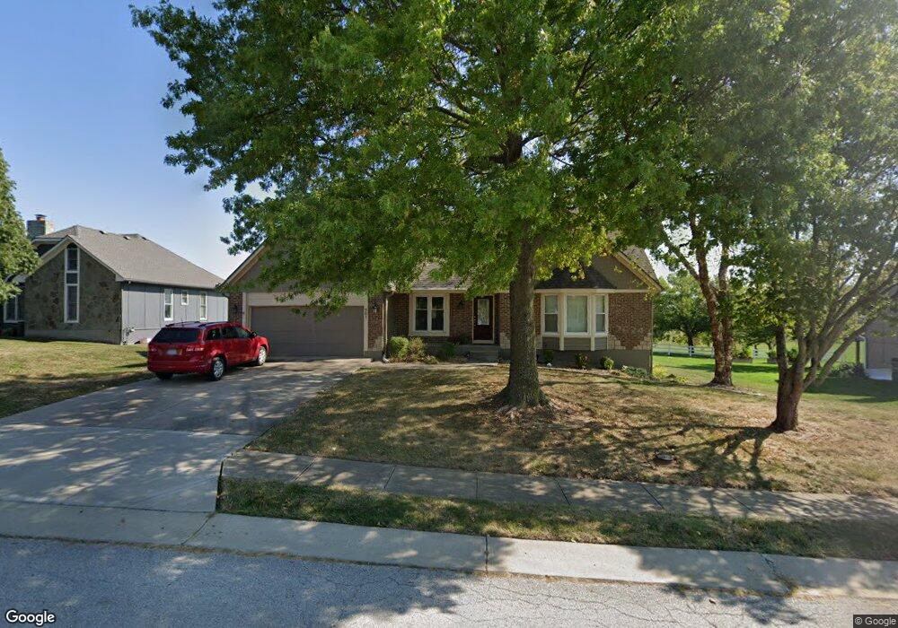
701 Condor St Raymore, MO 64083
Estimated Value: $404,218 - $505,000
3
Beds
2
Baths
2,939
Sq Ft
$161/Sq Ft
Est. Value
About This Home
This home is located at 701 Condor St, Raymore, MO 64083 and is currently estimated at $473,805, approximately $161 per square foot. 701 Condor St is a home located in Cass County with nearby schools including Raymore Elementary School, Raymore-Peculiar East Middle School, and Raymore-Peculiar Senior High School.
Ownership History
Date
Name
Owned For
Owner Type
Purchase Details
Closed on
Jun 30, 2018
Sold by
Parker James R and Parker Marsha A
Bought by
Pinkerton Michael D and Pinkerton Pamela S
Current Estimated Value
Home Financials for this Owner
Home Financials are based on the most recent Mortgage that was taken out on this home.
Original Mortgage
$261,250
Outstanding Balance
$225,972
Interest Rate
4.6%
Mortgage Type
New Conventional
Estimated Equity
$247,833
Purchase Details
Closed on
Sep 10, 2013
Sold by
Parker James R and Parker Marsha A
Bought by
Parker James R and Parker Marsha A
Create a Home Valuation Report for This Property
The Home Valuation Report is an in-depth analysis detailing your home's value as well as a comparison with similar homes in the area
Home Values in the Area
Average Home Value in this Area
Purchase History
| Date | Buyer | Sale Price | Title Company |
|---|---|---|---|
| Pinkerton Michael D | -- | American Title Group | |
| Parker James R | -- | None Available |
Source: Public Records
Mortgage History
| Date | Status | Borrower | Loan Amount |
|---|---|---|---|
| Open | Pinkerton Michael D | $261,250 |
Source: Public Records
Tax History
| Year | Tax Paid | Tax Assessment Tax Assessment Total Assessment is a certain percentage of the fair market value that is determined by local assessors to be the total taxable value of land and additions on the property. | Land | Improvement |
|---|---|---|---|---|
| 2025 | $3,767 | $52,370 | $5,750 | $46,620 |
| 2024 | $3,767 | $46,290 | $5,230 | $41,060 |
| 2023 | $3,762 | $46,290 | $5,230 | $41,060 |
| 2022 | $3,353 | $40,990 | $5,230 | $35,760 |
| 2021 | $3,354 | $40,990 | $5,230 | $35,760 |
| 2020 | $3,293 | $39,530 | $5,230 | $34,300 |
| 2019 | $3,179 | $39,530 | $5,230 | $34,300 |
| 2018 | $2,957 | $35,510 | $4,470 | $31,040 |
| 2017 | $2,699 | $35,510 | $4,470 | $31,040 |
| 2016 | $2,699 | $33,640 | $4,470 | $29,170 |
| 2015 | $2,701 | $33,640 | $4,470 | $29,170 |
| 2014 | $2,702 | $33,640 | $4,470 | $29,170 |
| 2013 | -- | $33,640 | $4,470 | $29,170 |
Source: Public Records
Map
Nearby Homes
- 720 Sandpiper St
- 702 Twilight Ct
- 528 S Saturn Dr
- 522 Neptune Dr
- 515 S Saturn Dr
- Lot 12 Municipal Cir
- Lot 6 Municipal Cir
- Lot 13 Municipal Cir
- 503 S Harrison Ave
- 605 S Franklin St
- 804 S Washington St
- 405 S Monroe St
- 305 E Olive St
- 506 S Adams St
- 211 S Franklin St
- 709 Derby St
- 0 Missouri 58
- 1024 S Madison St
- 204 N Pointe Ln
- 219 Pointe Ln
Your Personal Tour Guide
Ask me questions while you tour the home.