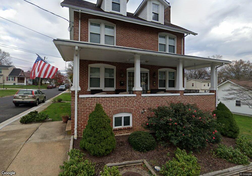
701 Maple Ave Wilmington, DE 19809
Estimated Value: $366,205 - $416,000
3
Beds
2
Baths
1,956
Sq Ft
$205/Sq Ft
Est. Value
About This Home
This home is located at 701 Maple Ave, Wilmington, DE 19809 and is currently estimated at $401,551, approximately $205 per square foot. 701 Maple Ave is a home located in New Castle County with nearby schools including Mount Pleasant Elementary School, Pierre S. Dupont Middle School, and Mount Pleasant High School.
Ownership History
Date
Name
Owned For
Owner Type
Purchase Details
Closed on
Sep 29, 2014
Sold by
Muller Allen R and Muller Ruth C
Bought by
Ferguson Melissa A
Current Estimated Value
Home Financials for this Owner
Home Financials are based on the most recent Mortgage that was taken out on this home.
Original Mortgage
$8,000
Outstanding Balance
$6,135
Interest Rate
4.11%
Mortgage Type
Stand Alone Second
Estimated Equity
$395,416
Create a Home Valuation Report for This Property
The Home Valuation Report is an in-depth analysis detailing your home's value as well as a comparison with similar homes in the area
Home Values in the Area
Average Home Value in this Area
Purchase History
| Date | Buyer | Sale Price | Title Company |
|---|---|---|---|
| Ferguson Melissa A | $239,900 | None Available |
Source: Public Records
Mortgage History
| Date | Status | Borrower | Loan Amount |
|---|---|---|---|
| Open | Ferguson Melissa A | $8,000 |
Source: Public Records
Tax History
| Year | Tax Paid | Tax Assessment Tax Assessment Total Assessment is a certain percentage of the fair market value that is determined by local assessors to be the total taxable value of land and additions on the property. | Land | Improvement |
|---|---|---|---|---|
| 2024 | $2,176 | $57,400 | $9,100 | $48,300 |
| 2023 | $1,990 | $57,400 | $9,100 | $48,300 |
| 2022 | $2,024 | $57,400 | $9,100 | $48,300 |
| 2021 | $2,022 | $57,400 | $9,100 | $48,300 |
| 2020 | $2,025 | $57,400 | $9,100 | $48,300 |
| 2019 | $2,330 | $57,400 | $9,100 | $48,300 |
| 2018 | $1,938 | $57,400 | $9,100 | $48,300 |
| 2017 | $1,908 | $57,400 | $9,100 | $48,300 |
| 2016 | $1,907 | $57,400 | $9,100 | $48,300 |
| 2015 | $1,754 | $57,400 | $9,100 | $48,300 |
| 2014 | $563 | $57,400 | $9,100 | $48,300 |
Source: Public Records
Map
Nearby Homes
- 402 Grove Ave
- 910 Marion Ave
- 302 River Rd Unit D8
- 1108 Prospect Ave
- 47 N Pennewell Dr
- 21 N Rodney Dr
- 26 S Pennewell Dr
- 12 N Rodney Dr
- 2 Polk Dr
- 408 Marsh Rd
- 37 S Cannon Dr
- 3 Paynter Dr
- 11 S Rodney Dr
- 518 Lennox Rd
- 5215 Le Parc Dr Unit 2
- 10 Brandywine Blvd
- 1325 Birch Ln
- 807 Birch Ln
- 132 Governor House Cir Unit 9
- 208 Philadelphia Pike
- 701 Maple Ave Unit BLFNT
- 704 Rosedale Ave
- 706 Rosedale Ave
- 711 Maple Ave
- 700 Maple Ave
- 702 Maple Ave
- 711 Grandview Ave
- 603 Maple Ave
- 704 Maple Ave
- 712 Rosedale Ave
- 794 Maple Ave
- 703 Rosedale Ave
- 613 Rosedale Ave
- 613 Rosedale Ave Unit BLFNT
- 706 Maple Ave
- 611 Rosedale Ave
- 715 Rosedale Ave
- 609 Rosedale Ave Unit 1
- 609 Rosedale Ave Unit 2
- 609 Rosedale Ave
Your Personal Tour Guide
Ask me questions while you tour the home.