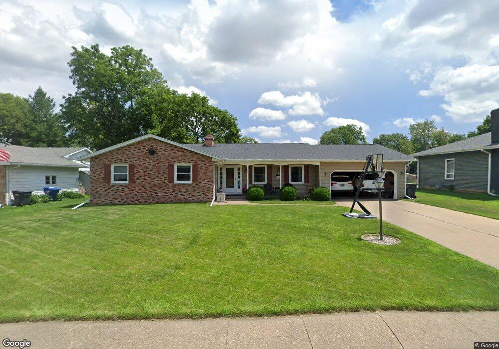
701 Orchard Ln Clinton, IA 52732
Estimated Value: $205,000 - $223,081
3
Beds
3
Baths
1,666
Sq Ft
$128/Sq Ft
Est. Value
About This Home
This home is located at 701 Orchard Ln, Clinton, IA 52732 and is currently estimated at $213,270, approximately $128 per square foot. 701 Orchard Ln is a home located in Clinton County with nearby schools including Whittier Elementary School, Clinton Middle School, and Clinton High School.
Ownership History
Date
Name
Owned For
Owner Type
Purchase Details
Closed on
Sep 26, 2008
Sold by
Goers Lynn Elizabeth
Bought by
Debo Steven A and Debo Trischa K
Current Estimated Value
Home Financials for this Owner
Home Financials are based on the most recent Mortgage that was taken out on this home.
Original Mortgage
$117,500
Outstanding Balance
$78,341
Interest Rate
6.57%
Mortgage Type
New Conventional
Estimated Equity
$134,929
Create a Home Valuation Report for This Property
The Home Valuation Report is an in-depth analysis detailing your home's value as well as a comparison with similar homes in the area
Home Values in the Area
Average Home Value in this Area
Purchase History
| Date | Buyer | Sale Price | Title Company |
|---|---|---|---|
| Debo Steven A | $155,000 | None Available |
Source: Public Records
Mortgage History
| Date | Status | Borrower | Loan Amount |
|---|---|---|---|
| Open | Debo Steven A | $117,500 |
Source: Public Records
Tax History Compared to Growth
Tax History
| Year | Tax Paid | Tax Assessment Tax Assessment Total Assessment is a certain percentage of the fair market value that is determined by local assessors to be the total taxable value of land and additions on the property. | Land | Improvement |
|---|---|---|---|---|
| 2025 | $3,260 | $209,420 | $33,920 | $175,500 |
| 2024 | $3,260 | $185,440 | $33,920 | $151,520 |
| 2023 | $3,210 | $185,440 | $33,920 | $151,520 |
| 2022 | $3,226 | $156,440 | $29,450 | $126,990 |
| 2021 | $3,354 | $156,440 | $29,450 | $126,990 |
| 2020 | $3,354 | $153,860 | $21,040 | $132,820 |
| 2019 | $3,464 | $153,860 | $0 | $0 |
| 2018 | $3,368 | $153,860 | $0 | $0 |
| 2017 | $3,470 | $153,860 | $0 | $0 |
| 2016 | $3,176 | $146,167 | $0 | $0 |
| 2015 | $3,176 | $146,167 | $0 | $0 |
| 2014 | $3,188 | $146,167 | $0 | $0 |
| 2013 | $3,140 | $0 | $0 | $0 |
Source: Public Records
Map
Nearby Homes
- 1400 8th Ave S
- 1510 7th Ave S
- 716 Terrace Dr
- 1330 Florence Ave
- 1315 Caroline Ave
- 1301 Caroline Ave
- 1216 9th Ave S
- 1201 9th Ave S
- 605 Melrose Ct
- 1813 Zara Trace St
- 1214 S 12th St
- 1836 Zara Trace
- 1830 Zara Trace
- 1824 Zara Trace
- 1818 Zara Trace
- 602 Kenilworth Ct
- 1825 5th Ave S
- 1121 2nd Ave S
- 1319 14th Ave S
- 610 Argyle Ct
- 637 Orchard Ln
- 709 Orchard Ln
- 715 Orchard Ln
- 1446 7th Ave S
- 1417 Caroline Ave
- 1456 7th Ave S
- 1450 7th Ave S
- 723 Orchard Ln
- 1463 7th Ave S
- 1400 Caroline Ave Unit 1400 Caroline
- 1408 Caroline Ave
- 1408 Caroline Ave Unit Ave
- 708 Orchard Ln
- 700 Orchard Ln
- 1464 7th Ave S
- 711 S 15th St
- 714 Orchard Ln
- 717 S 15th St
- 1430 8th Ave S
- 725 S 15th St