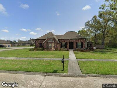
701 Renwick Blvd Berwick, LA 70342
Estimated Value: $474,000 - $523,000
4
Beds
4
Baths
--
Sq Ft
0.39
Acres
About This Home
This home is located at 701 Renwick Blvd, Berwick, LA 70342 and is currently estimated at $497,226. 701 Renwick Blvd is a home located in St. Mary Parish with nearby schools including Berwick Elementary School, Berwick Junior High School, and Berwick High School.
Ownership History
Date
Name
Owned For
Owner Type
Purchase Details
Closed on
Dec 6, 2022
Sold by
Hebert Carl Anthony
Bought by
Haywood Christopher Lee
Current Estimated Value
Purchase Details
Closed on
Feb 23, 2017
Sold by
Simmons Ii Jerry Tillman and Simmons Stacie Lemoine
Bought by
Kragthorpe Steven Jon and Kragthorpe Misty
Home Financials for this Owner
Home Financials are based on the most recent Mortgage that was taken out on this home.
Original Mortgage
$376,000
Interest Rate
4.19%
Mortgage Type
Stand Alone First
Create a Home Valuation Report for This Property
The Home Valuation Report is an in-depth analysis detailing your home's value as well as a comparison with similar homes in the area
Home Values in the Area
Average Home Value in this Area
Purchase History
| Date | Buyer | Sale Price | Title Company |
|---|---|---|---|
| Haywood Christopher Lee | $450,000 | -- | |
| Kragthorpe Steven Jon | $470,000 | Guaranteed Title, Llc |
Source: Public Records
Mortgage History
| Date | Status | Borrower | Loan Amount |
|---|---|---|---|
| Previous Owner | Hebert Carl A | $365,000 | |
| Previous Owner | Kragthorpe Steven Jon | $376,000 |
Source: Public Records
Tax History Compared to Growth
Tax History
| Year | Tax Paid | Tax Assessment Tax Assessment Total Assessment is a certain percentage of the fair market value that is determined by local assessors to be the total taxable value of land and additions on the property. | Land | Improvement |
|---|---|---|---|---|
| 2024 | $4,308 | $46,358 | $6,922 | $39,436 |
| 2023 | $3,354 | $46,358 | $6,922 | $39,436 |
| 2022 | $4,300 | $46,358 | $6,922 | $39,436 |
| 2021 | $4,317 | $46,358 | $6,922 | $39,436 |
| 2020 | $4,317 | $46,358 | $6,922 | $39,436 |
| 2019 | $4,134 | $46,358 | $6,922 | $39,436 |
| 2018 | $3,778 | $42,358 | $6,922 | $35,436 |
| 2017 | $3,857 | $43,240 | $4,600 | $38,640 |
| 2016 | $2,320 | $32,748 | $4,562 | $28,186 |
| 2015 | $2,312 | $32,195 | $4,562 | $27,633 |
| 2014 | $2,384 | $32,195 | $4,562 | $27,633 |
| 2013 | $2,384 | $32,195 | $4,562 | $27,633 |
Source: Public Records
Map
Nearby Homes
- 697 Victoria Dr
- 203 Jones St Unit 10
- 202 Hogan St
- 540 Pattie Dr
- 211 Hogan St
- 103 River Estates St
- 105 River Estates St
- 221 Hogan St
- 107 River Estates St
- 108 River Estates St
- 109 River Estates St
- 112 River Estates St
- 111 River Estates St
- 113 River Estates St
- 110 River Estates St
- 116 River Estates St
- 502 Whitworth St
- 118 River Estates St
- 114 River Estates St
- 115 River Estates St
- 701 Renwick Blvd
- 699 Victoria Dr
- 611 Renwick Blvd
- 698 Victoria Dr
- 700 Renwick Blvd
- 610 Renwick Blvd
- 701 Victoria Dr
- 500 Avalon Ct
- 728 Victoria Dr
- 604 Riverside Dr
- 607 Renwick Blvd
- 502 Avalon Ct
- 608 Renwick Blvd
- 703 Victoria Dr
- 602 Riverside Dr
- 613 Point Pleasant Dr
- 606 Renwick Blvd
- 705 Victoria Dr
- 611 Point Pleasant Dr
- 605 Renwick Blvd