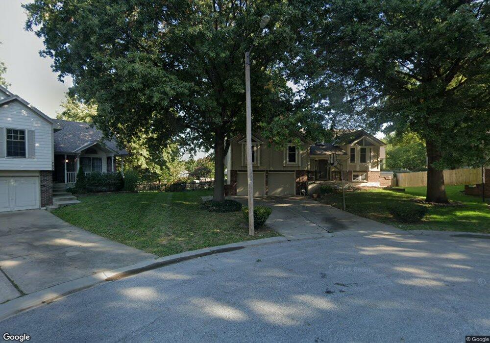
701 SE Basil Ct Lees Summit, MO 64063
Estimated Value: $346,000 - $354,000
3
Beds
2
Baths
1,600
Sq Ft
$219/Sq Ft
Est. Value
About This Home
This home is located at 701 SE Basil Ct, Lees Summit, MO 64063 and is currently estimated at $350,807, approximately $219 per square foot. 701 SE Basil Ct is a home located in Jackson County with nearby schools including Pleasant Lea Middle School, Lee's Summit Senior High School, and Summit Christian Academy.
Ownership History
Date
Name
Owned For
Owner Type
Purchase Details
Closed on
Apr 18, 2024
Sold by
Massood Linda R
Bought by
Massood Lester G
Current Estimated Value
Purchase Details
Closed on
Dec 22, 2010
Sold by
Massood Lester G and Massood George
Bought by
Massood Lester G and Massood George
Home Financials for this Owner
Home Financials are based on the most recent Mortgage that was taken out on this home.
Original Mortgage
$123,937
Interest Rate
4.41%
Mortgage Type
FHA
Purchase Details
Closed on
Nov 30, 2001
Sold by
Brumbaugh Karen K and Brumbaugh Keith A
Bought by
Massood Lester G and Massood George
Home Financials for this Owner
Home Financials are based on the most recent Mortgage that was taken out on this home.
Original Mortgage
$131,100
Interest Rate
6.57%
Mortgage Type
Purchase Money Mortgage
Purchase Details
Closed on
Aug 26, 1997
Sold by
Chambless Kenneth E
Bought by
Chambless Karen
Create a Home Valuation Report for This Property
The Home Valuation Report is an in-depth analysis detailing your home's value as well as a comparison with similar homes in the area
Home Values in the Area
Average Home Value in this Area
Purchase History
| Date | Buyer | Sale Price | Title Company |
|---|---|---|---|
| Massood Lester G | -- | None Listed On Document | |
| Massood Lester G | -- | Missouri Secured Title Lees | |
| Massood Lester G | -- | Security Land Title Co | |
| Chambless Karen | -- | -- |
Source: Public Records
Mortgage History
| Date | Status | Borrower | Loan Amount |
|---|---|---|---|
| Previous Owner | Massood Lester G | $123,937 | |
| Previous Owner | Massood Lester G | $131,100 |
Source: Public Records
Tax History
| Year | Tax Paid | Tax Assessment Tax Assessment Total Assessment is a certain percentage of the fair market value that is determined by local assessors to be the total taxable value of land and additions on the property. | Land | Improvement |
|---|---|---|---|---|
| 2025 | $4,106 | $54,526 | $9,285 | $45,241 |
| 2024 | $4,077 | $56,871 | $7,066 | $49,805 |
| 2023 | $4,077 | $56,871 | $6,399 | $50,472 |
| 2022 | $3,328 | $41,230 | $4,737 | $36,493 |
| 2021 | $3,397 | $41,230 | $4,737 | $36,493 |
| 2020 | $3,264 | $39,226 | $4,737 | $34,489 |
| 2019 | $3,175 | $39,226 | $4,737 | $34,489 |
| 2018 | $2,977 | $34,138 | $4,122 | $30,016 |
| 2017 | $2,977 | $34,138 | $4,122 | $30,016 |
| 2016 | $2,794 | $31,711 | $4,009 | $27,702 |
Source: Public Records
Map
Nearby Homes
- 1308 SE 7th St
- 729 SE Claremont St
- 1816 SE 7th St
- 1200 SE 7th St
- 1619 SE Boone Trail
- 1023 SE Timbercreek Ln
- 1023 SE Bordner Dr
- 1205 SE 5th St
- 727 SE 10th St
- 525 SE Vista Dr
- 308 SE Colony Dr
- 505 SE Onyx Dr
- 1225 SE 12th St
- 1220 SE 12th Terrace
- 1016 SE 6th St
- 1604 SE 11th St
- 302 SE Flagstone Dr
- 1111 SE 2nd Ct
- 719 SE London Way
- 1015 SE 3rd Terrace
- 705 SE Basil Ct
- 700 SE Basil Ct
- 724 SE Pierre Ave
- 728 SE Pierre Ave
- 704 SE Basil Ct
- 720 SE Pierre Ave
- 709 SE Basil Ct
- 623 SE Greenridge Dr
- 619 SE Greenridge Dr
- 732 SE Pierre Ave
- 615 SE Greenridge Dr
- 708 SE Basil Ct
- 703 SE Greenridge Dr
- 736 SE Pierre Ave
- 1604 SE 7th Terrace
- 1608 SE 7th Terrace
- 707 SE Greenridge Dr
- 712 SE Basil Ct
- 1612 SE 7th Terrace
- 711 SE Greenridge Dr
Your Personal Tour Guide
Ask me questions while you tour the home.