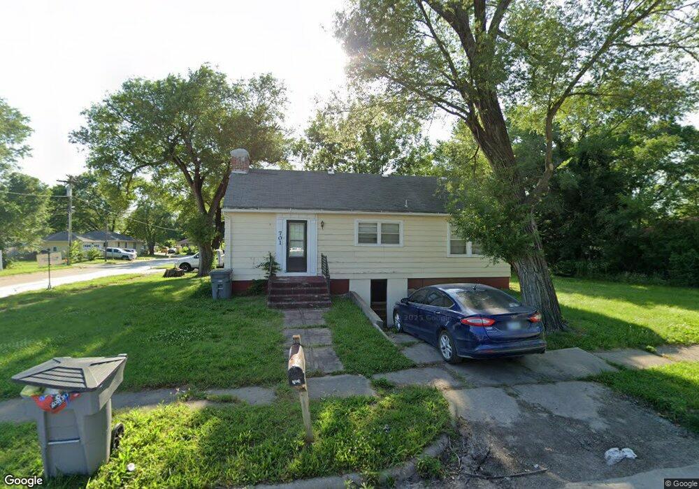
701 Sherman St Emporia, KS 66801
Estimated Value: $102,000 - $128,773
2
Beds
1
Bath
962
Sq Ft
$118/Sq Ft
Est. Value
About This Home
This home is located at 701 Sherman St, Emporia, KS 66801 and is currently estimated at $113,193, approximately $117 per square foot. 701 Sherman St is a home located in Lyon County with nearby schools including Village Elementary School, Emporia Middle School, and Emporia High School.
Ownership History
Date
Name
Owned For
Owner Type
Purchase Details
Closed on
Apr 23, 2025
Sold by
Selby Lyman L Living Trust
Bought by
Guzman Properties Llc
Current Estimated Value
Home Financials for this Owner
Home Financials are based on the most recent Mortgage that was taken out on this home.
Original Mortgage
$94,189
Outstanding Balance
$93,006
Interest Rate
0.67%
Mortgage Type
Construction
Estimated Equity
$20,187
Purchase Details
Closed on
Nov 1, 1998
Bought by
Louangboriboune Bounmak and Louangboriboune Nouanechanh
Create a Home Valuation Report for This Property
The Home Valuation Report is an in-depth analysis detailing your home's value as well as a comparison with similar homes in the area
Home Values in the Area
Average Home Value in this Area
Purchase History
| Date | Buyer | Sale Price | Title Company |
|---|---|---|---|
| Guzman Properties Llc | $117,736 | -- | |
| Louangboriboune Bounmak | $32,000 | -- |
Source: Public Records
Mortgage History
| Date | Status | Borrower | Loan Amount |
|---|---|---|---|
| Open | Guzman Properties Llc | $94,189 | |
| Closed | Guzman Properties Llc | $85,329 |
Source: Public Records
Tax History Compared to Growth
Tax History
| Year | Tax Paid | Tax Assessment Tax Assessment Total Assessment is a certain percentage of the fair market value that is determined by local assessors to be the total taxable value of land and additions on the property. | Land | Improvement |
|---|---|---|---|---|
| 2025 | $1,672 | $11,784 | $2,405 | $9,379 |
| 2024 | $1,672 | $10,911 | $2,132 | $8,779 |
| 2023 | $1,429 | $9,061 | $1,932 | $7,129 |
| 2022 | $1,117 | $7,406 | $1,585 | $5,821 |
| 2021 | $969 | $6,325 | $1,349 | $4,976 |
| 2020 | $814 | $6,233 | $1,255 | $4,978 |
| 2019 | $814 | $5,148 | $1,075 | $4,073 |
| 2018 | $776 | $4,903 | $1,075 | $3,828 |
| 2017 | $763 | $4,807 | $1,075 | $3,732 |
| 2016 | $519 | $3,358 | $1,075 | $2,283 |
| 2015 | -- | $5,451 | $1,076 | $4,375 |
| 2014 | -- | $5,451 | $1,080 | $4,371 |
Source: Public Records
Map
Nearby Homes
- 616 Sherman St
- 916 Garfield St
- 634 Lincoln St
- 1001 Woodland St
- 1018 Woodland St
- 419 Arundel St
- 1614 W 12th Ave
- 302 Garfield St
- 1218 Garfield St
- 1110 Thompson St
- 938 Luther St
- 1405 Lincoln St
- 874 W 5th Ave
- 746 W 7th Ave
- 742 W 7th Ave
- 1344 Prairie Park Ln
- 801 W 7th Ave
- 1222 Tomahawk Rd
- 807 W 9th Ave
- 1428 Prairie St
- 709 Sherman St
- 713 Sherman St
- 643 Sherman St
- 702 Sunnyslope St
- 706 Sunnyslope St
- 717 Sherman St
- 641 Sherman St
- 708 Sunnyslope St
- 640 Sunnyslope St
- 720 Sunnyslope St
- 646 Sherman St
- 721 Sherman St
- 639 Sherman St
- 638 Sunnyslope St
- 642 Sherman St
- 722 Sunnyslope St
- 632 Sunnyslope St
- 631 Sherman St
- 725 Sherman St
- 638 Sherman St