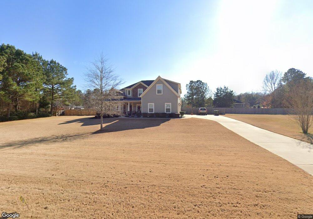
7013 Daniel Ct Upatoi, GA 31829
Estimated Value: $470,000 - $541,000
4
Beds
4
Baths
3,799
Sq Ft
$135/Sq Ft
Est. Value
About This Home
This home is located at 7013 Daniel Ct, Upatoi, GA 31829 and is currently estimated at $512,366, approximately $134 per square foot. 7013 Daniel Ct is a home located in Muscogee County with nearby schools including Mathews Elementary School, Aaron Cohn Middle School, and Shaw High School.
Ownership History
Date
Name
Owned For
Owner Type
Purchase Details
Closed on
Mar 15, 2017
Bought by
Mill Terrhonda C and Mills Samuel
Current Estimated Value
Home Financials for this Owner
Home Financials are based on the most recent Mortgage that was taken out on this home.
Original Mortgage
$310,408
Outstanding Balance
$257,264
Interest Rate
4.15%
Mortgage Type
VA
Estimated Equity
$255,102
Purchase Details
Closed on
Jun 28, 2016
Sold by
Atw Inc
Bought by
Ray M Wright Inc
Create a Home Valuation Report for This Property
The Home Valuation Report is an in-depth analysis detailing your home's value as well as a comparison with similar homes in the area
Home Values in the Area
Average Home Value in this Area
Purchase History
| Date | Buyer | Sale Price | Title Company |
|---|---|---|---|
| Mill Terrhonda C | $303,875 | -- | |
| Ray M Wright Inc | $50,347 | -- |
Source: Public Records
Mortgage History
| Date | Status | Borrower | Loan Amount |
|---|---|---|---|
| Open | Mill Terrhonda C | $310,408 |
Source: Public Records
Tax History Compared to Growth
Tax History
| Year | Tax Paid | Tax Assessment Tax Assessment Total Assessment is a certain percentage of the fair market value that is determined by local assessors to be the total taxable value of land and additions on the property. | Land | Improvement |
|---|---|---|---|---|
| 2025 | $359 | $197,412 | $17,084 | $180,328 |
| 2024 | $3,594 | $197,412 | $17,084 | $180,328 |
| 2023 | $303 | $197,412 | $17,084 | $180,328 |
| 2022 | $3,776 | $171,248 | $17,084 | $154,164 |
| 2021 | $3,769 | $130,740 | $17,084 | $113,656 |
| 2020 | $3,770 | $130,740 | $17,084 | $113,656 |
| 2019 | $3,786 | $130,740 | $17,084 | $113,656 |
| 2018 | $3,786 | $121,520 | $15,360 | $106,160 |
| 2017 | $3,124 | $88,952 | $17,084 | $71,868 |
| 2016 | $705 | $20,000 | $20,000 | $0 |
| 2015 | $706 | $20,000 | $20,000 | $0 |
| 2014 | $707 | $20,000 | $20,000 | $0 |
| 2013 | -- | $20,000 | $20,000 | $0 |
Source: Public Records
Map
Nearby Homes
- 7019 Kendall Creek Dr
- 8701 Mckee Rd
- 8711 Mckee Rd
- 8715 Mckee Rd
- 8695 Mckee Rd
- 8705 Mckee Rd
- 8585 Mckee Rd
- 7524 Hedgestone Dr
- 14270 Cross Creek Rd
- 7346 Hedgestone Dr
- 0 Boyd Ct
- 7901 Shallowford Rd
- 13642 Macon Rd
- 7232 Woodhaven Dr
- 64 Steele Creek Dr
- 57 Old Chimney Ct
- Cypress Plan at Bowers Creek
- Cannaberra Plan at Bowers Creek
- Belmont Plan at Bowers Creek
- Jackson Plan at Bowers Creek
- 7009 Daniel Ct
- 7006 Kendall Creek Dr
- 7017 Daniel Ct
- 7002 Kendall Creek Dr
- 0 Daniel Ct Unit 3215928
- 0 Daniel Ct
- 7012 Daniel Ct
- 7016 Daniel Ct
- 7010 Kendall Creek Dr
- 7008 Daniel Ct
- 7005 Daniel Ct
- 7007 Kendall Creek Dr
- 7003 Kendall Creek Dr
- 0 Kendall Creek Dr
- 7014 Kendall Creek Dr
- 7004 Daniel Ct
- 8317 Mckee Rd
- 7011 Kendall Creek Dr
- 8311 Mckee Rd
- 7003 Daniels Ct