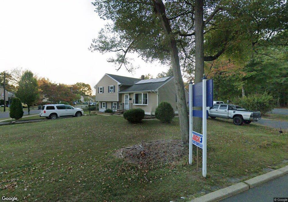
702 Cedar Crest Dr Bound Brook, NJ 08805
Estimated Value: $541,472 - $583,000
3
Beds
2
Baths
1,554
Sq Ft
$361/Sq Ft
Est. Value
About This Home
This home is located at 702 Cedar Crest Dr, Bound Brook, NJ 08805 and is currently estimated at $561,118, approximately $361 per square foot. 702 Cedar Crest Dr is a home located in Somerset County with nearby schools including Adamsville Primary School, Bridgewater-Raritan Middle School, and Hillside Intermediate School.
Ownership History
Date
Name
Owned For
Owner Type
Purchase Details
Closed on
Dec 5, 2025
Sold by
Velasco-Gutierrez Jose B and Velasco Maricela Rojas
Bought by
Velasco-Gutierrez Jose B
Current Estimated Value
Home Financials for this Owner
Home Financials are based on the most recent Mortgage that was taken out on this home.
Original Mortgage
$400,000
Outstanding Balance
$399,227
Interest Rate
6.17%
Mortgage Type
New Conventional
Estimated Equity
$161,891
Purchase Details
Closed on
Nov 14, 2011
Sold by
Voorhees Matthew L and Voorhees Helen M
Bought by
Velasco Jose and Velasco Maricela Rojas
Home Financials for this Owner
Home Financials are based on the most recent Mortgage that was taken out on this home.
Original Mortgage
$243,662
Interest Rate
4.4%
Mortgage Type
FHA
Purchase Details
Closed on
Sep 22, 1999
Sold by
Westphal August
Bought by
Voorhees Matthew and Kana Helen
Home Financials for this Owner
Home Financials are based on the most recent Mortgage that was taken out on this home.
Original Mortgage
$135,800
Interest Rate
8.1%
Create a Home Valuation Report for This Property
The Home Valuation Report is an in-depth analysis detailing your home's value as well as a comparison with similar homes in the area
Home Values in the Area
Average Home Value in this Area
Purchase History
| Date | Buyer | Sale Price | Title Company |
|---|---|---|---|
| Velasco-Gutierrez Jose B | -- | Hometown Title | |
| Velasco Jose | $250,000 | Multiple | |
| Voorhees Matthew | $143,000 | -- |
Source: Public Records
Mortgage History
| Date | Status | Borrower | Loan Amount |
|---|---|---|---|
| Open | Velasco-Gutierrez Jose B | $400,000 | |
| Previous Owner | Velasco Jose | $243,662 | |
| Previous Owner | Voorhees Matthew | $135,800 |
Source: Public Records
Tax History
| Year | Tax Paid | Tax Assessment Tax Assessment Total Assessment is a certain percentage of the fair market value that is determined by local assessors to be the total taxable value of land and additions on the property. | Land | Improvement |
|---|---|---|---|---|
| 2025 | $10,417 | $484,300 | $258,400 | $225,900 |
| 2024 | $10,417 | $459,100 | $239,400 | $219,700 |
| 2023 | $10,368 | $439,700 | $225,200 | $214,500 |
| 2022 | $9,678 | $389,000 | $206,200 | $182,800 |
| 2021 | $8,630 | $318,600 | $163,400 | $155,200 |
| 2020 | $8,869 | $287,300 | $144,400 | $142,900 |
| 2019 | $8,630 | $266,600 | $144,400 | $122,200 |
| 2018 | $8,478 | $254,300 | $130,200 | $124,100 |
| 2017 | $8,449 | $247,700 | $125,400 | $122,300 |
| 2016 | $8,167 | $241,200 | $96,900 | $144,300 |
| 2015 | $7,903 | $238,700 | $87,400 | $151,300 |
| 2014 | $7,884 | $230,000 | $87,400 | $142,600 |
Source: Public Records
Map
Nearby Homes
- 22 Glen Rd
- 428 Helfin St
- 309 Stratford Place Unit 309
- 617 Vosseller Ave
- 606 Vosseller Ave
- 561 Marion St
- 514 Longwood Ave
- 126 W High St
- 432 Talmage Ave
- 650 Central Ave
- 162 Linden Ave
- 261 W Main St
- 306 Church St
- 328 John St
- 17 Talmage Ave
- 589 Mountain Ave
- 309 Jamestown Rd
- 408 E Union Ave
- 811 Mountain Ave
- 730 Park Ave
- 706 Cedar Crest Dr
- 701 Cedar Crest Dr
- 710 Cedar Crest Dr
- 705 Cedar Crest Dr
- 645 Thompson Ave
- 332 Chimney Rock Rd
- 709 Cedar Crest Dr
- 42 Village Ct
- 44 Village Ct
- 714 Cedar Crest Dr
- 643 Thompson Ave
- 46 Village Ct
- 658 Thompson Ave
- 713 Cedar Crest Dr
- 48 Village Ct
- 691 Crescent Dr
- 689 Crescent Dr
- 24 Glen Rd
- 687 Crescent Dr
- 685 Crescent Dr
Your Personal Tour Guide
Ask me questions while you tour the home.