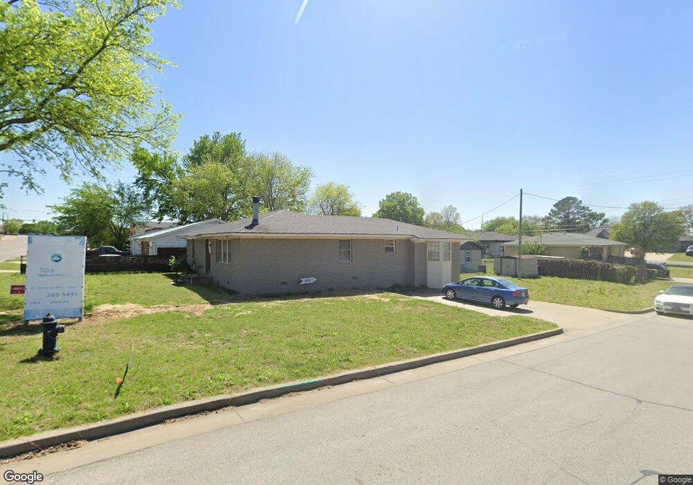
702 S Mission St Sapulpa, OK 74066
Estimated Value: $174,239 - $206,000
3
Beds
2
Baths
1,616
Sq Ft
$120/Sq Ft
Est. Value
About This Home
This home is located at 702 S Mission St, Sapulpa, OK 74066 and is currently estimated at $193,310, approximately $119 per square foot. 702 S Mission St is a home located in Creek County with nearby schools including Sapulpa Middle School, Sapulpa Junior High School, and Sapulpa High School.
Ownership History
Date
Name
Owned For
Owner Type
Purchase Details
Closed on
Feb 16, 2022
Sold by
Logan and Tad
Bought by
Logan Shannon and Waters Tad
Current Estimated Value
Home Financials for this Owner
Home Financials are based on the most recent Mortgage that was taken out on this home.
Original Mortgage
$50,000
Outstanding Balance
$43,361
Interest Rate
3.69%
Mortgage Type
Credit Line Revolving
Estimated Equity
$149,949
Purchase Details
Closed on
Dec 3, 2015
Sold by
Mefford Deborah Jean and Mefford Thomas L
Bought by
Logan Shannon
Create a Home Valuation Report for This Property
The Home Valuation Report is an in-depth analysis detailing your home's value as well as a comparison with similar homes in the area
Home Values in the Area
Average Home Value in this Area
Purchase History
| Date | Buyer | Sale Price | Title Company |
|---|---|---|---|
| Logan Shannon | -- | Integrity Title & Closing | |
| Logan Shannon | $137,000 | Executives Title & Escrow Co |
Source: Public Records
Mortgage History
| Date | Status | Borrower | Loan Amount |
|---|---|---|---|
| Open | Logan Shannon | $50,000 |
Source: Public Records
Tax History Compared to Growth
Tax History
| Year | Tax Paid | Tax Assessment Tax Assessment Total Assessment is a certain percentage of the fair market value that is determined by local assessors to be the total taxable value of land and additions on the property. | Land | Improvement |
|---|---|---|---|---|
| 2025 | $1,389 | $12,801 | $975 | $11,826 |
| 2024 | $1,389 | $12,427 | $975 | $11,452 |
| 2023 | $1,389 | $12,066 | $975 | $11,091 |
| 2022 | $1,231 | $11,714 | $975 | $10,739 |
| 2021 | $1,231 | $11,373 | $975 | $10,398 |
| 2020 | $1,193 | $11,111 | $975 | $10,136 |
| 2019 | $1,879 | $16,848 | $975 | $15,873 |
| 2018 | $1,859 | $16,357 | $975 | $15,382 |
| 2017 | $1,849 | $16,357 | $975 | $15,382 |
| 2016 | $1,872 | $16,357 | $975 | $15,382 |
| 2015 | -- | $6,584 | $2,442 | $4,142 |
| 2014 | -- | $6,584 | $2,442 | $4,142 |
Source: Public Records
Map
Nearby Homes
- 0 Division St Unit 2535888
- 1210 Maybelle Dr
- 813 E Teresa Ave
- 1103 S Division St
- 1109 S Division St
- 511 S Maple St
- 1010 E Thompson Ave
- 1440 Mabelle Dr
- 1033 E Thompson Ave
- 1023 E Thompson Ave
- 706 E Thompson Ave
- 320 E Mckinley Ave
- 207 S Walnut St
- 819 Ridge Rd
- 507 S Park St
- 612 S Park St
- 1014 Ridge Rd
- 1608 Glendale Rd
- 1140 E Hobson Ave
- 1805 Glendale Rd
- 708 S Mission St
- 716 S Mission St
- 1024 E Grayson Ave
- 705 S Quenath St
- 715 S Quenath St
- 718 S Mission St
- 717 S Quenath St
- 621 S Mission St
- 702 S Quenath St
- 624 S Hiawatha St
- 714 S Quenath St
- 630 S Hiawatha St
- 636 S Hiawatha St
- 720 S Quenath St
- 622 S Hiawatha St
- 723 S Quenath St
- 620 S Hiawatha St
- 703 S Division St
- 705 S Division St
- 618 S Hiawatha St