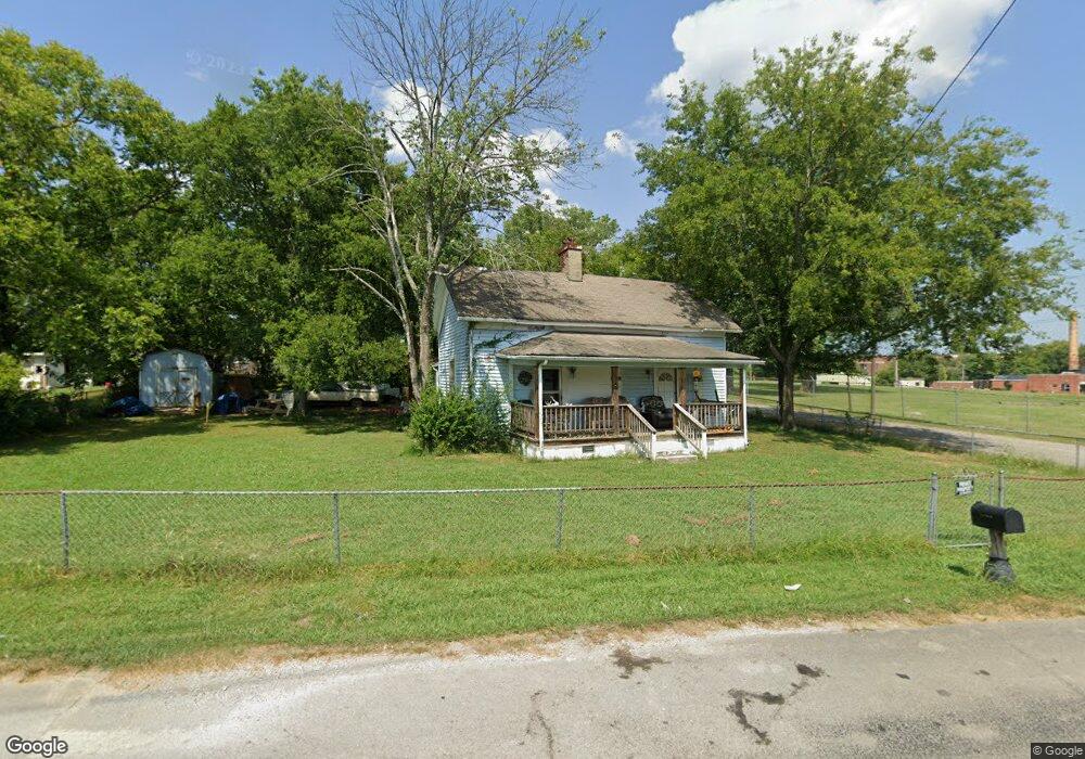
702 W Church St Lewisburg, TN 37091
Estimated Value: $152,000 - $219,000
--
Bed
1
Bath
1,280
Sq Ft
$143/Sq Ft
Est. Value
About This Home
This home is located at 702 W Church St, Lewisburg, TN 37091 and is currently estimated at $183,182, approximately $143 per square foot. 702 W Church St is a home located in Marshall County with nearby schools including Marshall Elementary School, Oak Grove Elementary School, and Westhills Elementary School.
Ownership History
Date
Name
Owned For
Owner Type
Purchase Details
Closed on
Nov 30, 2022
Sold by
Wiser Mechel N
Bought by
Wiser Mechel N
Current Estimated Value
Purchase Details
Closed on
May 6, 2011
Sold by
Ford Misty Michelle
Bought by
Wiser Bobby Lee
Purchase Details
Closed on
Nov 17, 1998
Bought by
Jones Bryant Charles Sonja L
Purchase Details
Closed on
Aug 25, 1994
Bought by
Redwine Sharon E
Purchase Details
Closed on
Apr 9, 1990
Bought by
Billingsley John B and Billingsley Tracy D
Purchase Details
Closed on
Dec 5, 1989
Bought by
Cavalry Banking
Create a Home Valuation Report for This Property
The Home Valuation Report is an in-depth analysis detailing your home's value as well as a comparison with similar homes in the area
Home Values in the Area
Average Home Value in this Area
Purchase History
| Date | Buyer | Sale Price | Title Company |
|---|---|---|---|
| Wiser Mechel N | -- | -- | |
| Wiser Bobby Lee | $12,500 | -- | |
| Jones Bryant Charles Sonja L | $37,500 | -- | |
| Redwine Sharon E | $28,500 | -- | |
| Billingsley John B | $14,000 | -- | |
| Cavalry Banking | $20,000 | -- |
Source: Public Records
Tax History Compared to Growth
Tax History
| Year | Tax Paid | Tax Assessment Tax Assessment Total Assessment is a certain percentage of the fair market value that is determined by local assessors to be the total taxable value of land and additions on the property. | Land | Improvement |
|---|---|---|---|---|
| 2024 | -- | $19,100 | $3,125 | $15,975 |
| 2023 | $592 | $19,100 | $3,125 | $15,975 |
| 2022 | $592 | $19,100 | $3,125 | $15,975 |
| 2021 | $495 | $10,650 | $1,575 | $9,075 |
| 2020 | $495 | $10,650 | $1,575 | $9,075 |
| 2019 | $479 | $10,650 | $1,575 | $9,075 |
| 2018 | $474 | $10,650 | $1,575 | $9,075 |
| 2017 | $474 | $10,650 | $1,575 | $9,075 |
| 2016 | $442 | $8,625 | $1,750 | $6,875 |
| 2015 | $403 | $8,625 | $1,750 | $6,875 |
| 2014 | $403 | $8,625 | $1,750 | $6,875 |
Source: Public Records
Map
Nearby Homes
- 726 Thomas Ave
- 518 Maple St
- 0 New Lake Rd Unit RTC3030964
- 610 Forrest St
- 215 5th Ave N
- 525 Maple St
- 316 Haynes St
- 117 W End Ave N
- 630 6th Ave N
- 1111 W End Ave N
- 594 5th Ave N
- 627 6th Ave N
- 108 W End Ave N
- 1221 W Commerce St
- 251 Joyce Ave
- 1144 Apple St
- 240 Joyce Ave
- 416 1st Ave N
- 543 2nd Ave N
- 632 Colburn Dr
- 712 W Church St
- 716 W Church St
- 118 7th Ave N
- 117 7th Ave N
- 726 W Church St
- 727 W Church St
- 732 W Commerce St
- 732 W Church St
- 724 W Commerce St
- 738 W Church St
- 752 W Commerce St
- 735 W Church St
- 802 W Church St
- 642 W Commerce St
- 743 W Commerce St
- 305 7th Ave N
- 764 W Commerce St
- 733 W Commerce St
- 751 W Commerce St Unit A
- 751 W Commerce St Unit B