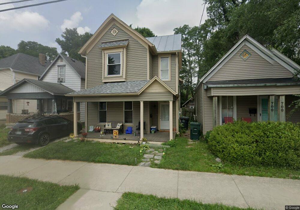
702 W Main St Muncie, IN 47305
Old West End NeighborhoodEstimated Value: $65,000 - $92,000
2
Beds
2
Baths
1,382
Sq Ft
$55/Sq Ft
Est. Value
About This Home
This home is located at 702 W Main St, Muncie, IN 47305 and is currently estimated at $76,000, approximately $54 per square foot. 702 W Main St is a home located in Delaware County with nearby schools including Muncie Central High School, South View Elementary School, and Northside Middle School.
Ownership History
Date
Name
Owned For
Owner Type
Purchase Details
Closed on
Jul 31, 2013
Sold by
City Of Muncie Dept Redevelopm
Bought by
Muncie Urban Enterprise Assn
Current Estimated Value
Purchase Details
Closed on
Mar 1, 2013
Sold by
Benavides Rudy C
Bought by
City Of Muncie Department Of Redevelopme
Purchase Details
Closed on
Nov 16, 2009
Sold by
Benavides Richard C
Bought by
Benavides Rudy C
Create a Home Valuation Report for This Property
The Home Valuation Report is an in-depth analysis detailing your home's value as well as a comparison with similar homes in the area
Home Values in the Area
Average Home Value in this Area
Purchase History
| Date | Buyer | Sale Price | Title Company |
|---|---|---|---|
| Muncie Urban Enterprise Assn | -- | -- | |
| City Of Muncie Department Of Redevelopme | -- | None Available | |
| Benavides Rudy C | -- | None Available |
Source: Public Records
Tax History Compared to Growth
Tax History
| Year | Tax Paid | Tax Assessment Tax Assessment Total Assessment is a certain percentage of the fair market value that is determined by local assessors to be the total taxable value of land and additions on the property. | Land | Improvement |
|---|---|---|---|---|
| 2024 | $178 | $0 | $0 | $0 |
| 2023 | $230 | $0 | $0 | $0 |
| 2022 | $108 | $0 | $0 | $0 |
| 2021 | $108 | $0 | $0 | $0 |
| 2020 | $108 | $0 | $0 | $0 |
| 2019 | $108 | $0 | $0 | $0 |
| 2018 | $108 | $0 | $0 | $0 |
| 2017 | $108 | $0 | $0 | $0 |
| 2016 | $108 | $0 | $0 | $0 |
| 2014 | $61 | $0 | $0 | $0 |
| 2013 | -- | $0 | $0 | $0 |
Source: Public Records
Map
Nearby Homes
- 312 S Gharkey St
- 407 W Adams St
- 303 S Proud St
- 305 S Proud St
- 725 W Charles St
- 429 W Charles St
- 502 S Mound St
- 415 W Howard St
- 27 W Orchard Place
- 114 S Walnut St
- 114 S Walnut St Unit 100 & 200
- 709 W Riverside Ave
- 925 W Powers St
- 709 N Wheeling Ave
- 601 W Riverside Ave
- 1024 W Powers St
- 1008 W 1st St
- 719 N Mulberry St
- 1300 W University Ave
- 800-802 N Jefferson St