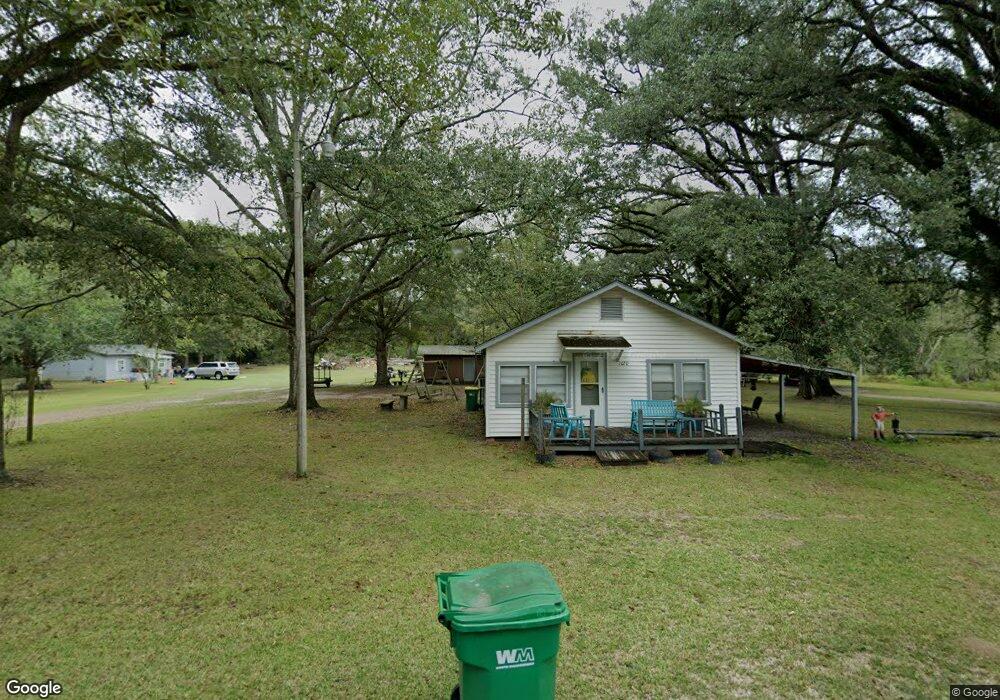
7020 Shady Ln Moss Point, MS 39562
Estimated Value: $92,959 - $181,000
--
Bed
--
Bath
791
Sq Ft
$167/Sq Ft
Est. Value
About This Home
This home is located at 7020 Shady Ln, Moss Point, MS 39562 and is currently estimated at $132,240, approximately $167 per square foot. 7020 Shady Ln is a home with nearby schools including East Central Lower Elementary School, East Central Upper Elementary School, and East Central Middle School.
Ownership History
Date
Name
Owned For
Owner Type
Purchase Details
Closed on
Jan 16, 2025
Sold by
Stanford Betty Pearl
Bought by
Stanford Betty Pearl and Trochessett Melanie Stanford
Current Estimated Value
Purchase Details
Closed on
May 13, 2015
Sold by
Last Will & Testament Of Emmitt Jewell S
Bought by
Stanford Betty Pearl
Purchase Details
Closed on
Dec 5, 2011
Sold by
Dutton Joseph Leroy
Bought by
Stanford E J
Create a Home Valuation Report for This Property
The Home Valuation Report is an in-depth analysis detailing your home's value as well as a comparison with similar homes in the area
Home Values in the Area
Average Home Value in this Area
Purchase History
| Date | Buyer | Sale Price | Title Company |
|---|---|---|---|
| Stanford Betty Pearl | -- | None Listed On Document | |
| Stanford Betty Pearl | -- | None Listed On Document | |
| Stanford Betty Pearl | -- | None Available | |
| Stanford E J | -- | -- |
Source: Public Records
Tax History Compared to Growth
Tax History
| Year | Tax Paid | Tax Assessment Tax Assessment Total Assessment is a certain percentage of the fair market value that is determined by local assessors to be the total taxable value of land and additions on the property. | Land | Improvement |
|---|---|---|---|---|
| 2024 | -- | $6,990 | $2,171 | $4,819 |
| 2023 | $0 | $6,990 | $2,171 | $4,819 |
| 2022 | $0 | $5,382 | $0 | $0 |
| 2021 | $965 | $5,382 | $5,382 | $0 |
| 2020 | $965 | $5,382 | $2,011 | $3,371 |
| 2019 | $965 | $8,074 | $3,017 | $5,057 |
| 2018 | $983 | $8,074 | $3,017 | $5,057 |
| 2017 | $1,000 | $8,074 | $3,017 | $5,057 |
| 2016 | $961 | $8,074 | $3,017 | $5,057 |
| 2015 | $913 | $50,860 | $20,110 | $30,750 |
| 2014 | $896 | $7,630 | $3,017 | $4,613 |
| 2013 | $934 | $8,225 | $3,017 | $5,208 |
Source: Public Records
Map
Nearby Homes
- 6709 Caraway Rd
- 0 Mississippi 614
- 6105 Mccormack Rd
- 22817 Alamosa Dr
- 21217 E Trails End Rd
- 8012 Coleman Homestead Rd
- 23117 Hinton Rd
- Lot 32 Huckleberry Ln
- 23601 Hinton Rd
- 21551 John Holder Rd
- 5402 Huckleberry Ln
- 22020 John Holder Rd
- 23ac Hinton Rd
- 6201 Lum Reeves Rd
- 0 Ramie Farm Rd
- 6745 Whites Farm Rd
- 24040 Robert e Lee Rd
- 24000 Robert e Lee Rd
- 7805 Songbird Ln
- 0 Hwy 613 Unit 4108899
- 6901 Shady Ln
- 22100 Parker Ln
- 22109 Arrow Trail
- 7120 Shady Ln
- 7130 Shady Ln
- 7201 Shady Ln
- 22000 Parker Ln
- 7200 Shady Ln
- 6924 Shady Ln
- 22205 Sassafras Ave
- 7131 Campground Rd
- 7009 Campground Rd
- 7001 Campground Rd
- 7205 Shady Ln
- 22108 Hollyhock Dr
- 7135 Campground Rd
- 22208 Hollyhock Dr
- 22004 Hollyhock Dr
- 22020 Hollyhock Dr
- 22000 Campground Rd