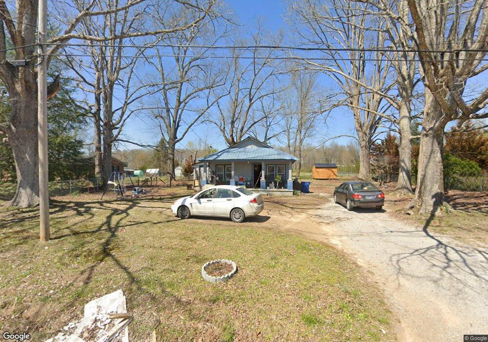
703 Ragsdale Rd Manchester, TN 37355
Estimated Value: $133,565 - $228,000
--
Bed
1
Bath
1,207
Sq Ft
$148/Sq Ft
Est. Value
About This Home
This home is located at 703 Ragsdale Rd, Manchester, TN 37355 and is currently estimated at $178,391, approximately $147 per square foot. 703 Ragsdale Rd is a home located in Coffee County with nearby schools including Westwood Middle School and Temple Baptist Christian School.
Ownership History
Date
Name
Owned For
Owner Type
Purchase Details
Closed on
Jul 17, 2012
Sold by
Wilhoit William O
Bought by
Brown Kelly R
Current Estimated Value
Purchase Details
Closed on
May 31, 2001
Bought by
Wilhoit William O and Brown Kelly R
Purchase Details
Closed on
Oct 13, 1999
Sold by
Mckinney David L
Bought by
Mckinney Tammy L
Purchase Details
Closed on
Jan 12, 1994
Bought by
Marlin Fletcher and Long Patti
Purchase Details
Closed on
Jul 27, 1993
Bought by
Reed Bob N Joyce J
Create a Home Valuation Report for This Property
The Home Valuation Report is an in-depth analysis detailing your home's value as well as a comparison with similar homes in the area
Home Values in the Area
Average Home Value in this Area
Purchase History
| Date | Buyer | Sale Price | Title Company |
|---|---|---|---|
| Brown Kelly R | -- | -- | |
| Wilhoit William O | $39,000 | -- | |
| Mckinney Tammy L | -- | -- | |
| Marlin Fletcher | $25,000 | -- | |
| Reed Bob N Joyce J | $11,000 | -- |
Source: Public Records
Tax History Compared to Growth
Tax History
| Year | Tax Paid | Tax Assessment Tax Assessment Total Assessment is a certain percentage of the fair market value that is determined by local assessors to be the total taxable value of land and additions on the property. | Land | Improvement |
|---|---|---|---|---|
| 2024 | $580 | $13,750 | $5,000 | $8,750 |
| 2023 | $580 | $13,750 | $0 | $0 |
| 2022 | $499 | $13,750 | $5,000 | $8,750 |
| 2021 | $526 | $11,475 | $3,425 | $8,050 |
| 2020 | $526 | $11,475 | $3,425 | $8,050 |
| 2019 | $526 | $11,475 | $3,425 | $8,050 |
| 2018 | $526 | $11,475 | $3,375 | $8,100 |
| 2017 | $609 | $11,600 | $3,675 | $7,925 |
| 2016 | $609 | $11,600 | $3,675 | $7,925 |
| 2015 | $608 | $11,600 | $3,675 | $7,925 |
| 2014 | $608 | $11,596 | $0 | $0 |
Source: Public Records
Map
Nearby Homes
- 775 Ragsdale Rd
- 627 Ragsdale Rd
- 1292 McMinnville Hwy
- 215 Wellington Dr
- 793 Old Bushy Branch Rd
- 1395 Ragsdale Rd
- 416 Powers Rd
- 304 W Lynn Dr
- 31 Stonehenge Ln S
- 54 Stonehenge Ln E
- 76 Stonehenge Ln N
- 58 Stonehenge Ln
- 1989 Elevation JKL Plan at Stonehenge
- 1726 Elevation JKL Plan at Stonehenge
- 1824 Elevation JKL Plan at Stonehenge
- 1258 Stonehenge Plan at Stonehenge
- 2073 Elevation JKL Plan at Stonehenge
- 1624 Elevation JKL Plan at Stonehenge
- Henry Plan at Stonehenge
- 1315 Elevation JKL Plan at Stonehenge
- 725 Ragsdale Rd
- 679 Ragsdale Rd
- 716 Ragsdale Rd
- 684 Ragsdale Rd
- 751 Ragsdale Rd
- 742 Ragsdale Rd
- 768 Ragsdale Rd
- 618 Ragsdale Rd
- 593 Ragsdale Rd
- 815 Ragsdale Rd
- 0 Circle Ave
- 80 Circle Ave
- 839 Ragsdale Rd
- 128 Circle Ave
- 848 Ragsdale Rd
- 130 Circle Ave
- 51 Swing Away Dr
- 79 Swing Away Dr
- 870 Ragsdale Rd
- 881 Ragsdale Rd