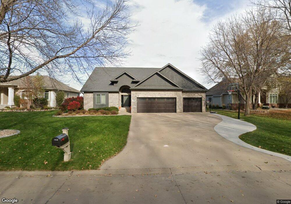
703 St Andrews Cir Dakota Dunes, SD 57049
Dakota Dunes NeighborhoodEstimated Value: $615,152 - $676,000
4
Beds
4
Baths
2,695
Sq Ft
$240/Sq Ft
Est. Value
About This Home
This home is located at 703 St Andrews Cir, Dakota Dunes, SD 57049 and is currently estimated at $647,788, approximately $240 per square foot. 703 St Andrews Cir is a home located in Union County with nearby schools including Dakota Valley Elementary School, Dakota Valley Junior High School, and Dakota Valley High School.
Ownership History
Date
Name
Owned For
Owner Type
Purchase Details
Closed on
Jun 2, 2023
Sold by
Monk Eric
Bought by
Otten Jarad and Otten Megan
Current Estimated Value
Purchase Details
Closed on
Oct 5, 2007
Sold by
Quigley Francis
Bought by
Vangessel Ike Van and Vangessel Van Gessel
Home Financials for this Owner
Home Financials are based on the most recent Mortgage that was taken out on this home.
Original Mortgage
$352,000
Interest Rate
6.55%
Mortgage Type
New Conventional
Create a Home Valuation Report for This Property
The Home Valuation Report is an in-depth analysis detailing your home's value as well as a comparison with similar homes in the area
Home Values in the Area
Average Home Value in this Area
Purchase History
| Date | Buyer | Sale Price | Title Company |
|---|---|---|---|
| Otten Jarad | $550,000 | -- | |
| Vangessel Ike Van | $352,000 | None Available |
Source: Public Records
Mortgage History
| Date | Status | Borrower | Loan Amount |
|---|---|---|---|
| Previous Owner | Vangessel Ike Van | $352,000 |
Source: Public Records
Tax History Compared to Growth
Tax History
| Year | Tax Paid | Tax Assessment Tax Assessment Total Assessment is a certain percentage of the fair market value that is determined by local assessors to be the total taxable value of land and additions on the property. | Land | Improvement |
|---|---|---|---|---|
| 2025 | $7,130 | $457,319 | $55,539 | $401,780 |
| 2024 | $7,130 | $457,319 | $55,539 | $401,780 |
| 2023 | $7,175 | $457,319 | $55,539 | $401,780 |
| 2022 | $6,418 | $379,248 | $44,431 | $334,817 |
| 2021 | $6,371 | $379,248 | $44,431 | $334,817 |
| 2020 | $6,358 | $363,304 | $44,431 | $318,873 |
| 2019 | $6,114 | $363,304 | $44,431 | $318,873 |
| 2018 | $6,217 | $363,304 | $44,431 | $318,873 |
| 2017 | $6,112 | $363,304 | $0 | $363,304 |
| 2016 | $6,428 | $363,304 | $0 | $363,304 |
| 2015 | $6,428 | $363,304 | $0 | $363,304 |
| 2014 | $5,082 | $274,390 | $0 | $274,390 |
| 2013 | $5,261 | $274,390 | $0 | $274,390 |
| 2012 | $5,261 | $274,390 | $44,431 | $229,959 |
Source: Public Records
Map
Nearby Homes
- 822 E Saint Andrews Cir
- 652 E Sawgrass Trail
- 707 Prairie Blvd
- 875 E Sawgrass Trail
- 460 N Royal Troon Dr
- 856 E Sawgrass Trail
- 1060 Pebble Beach Dr
- 728 Prairie Blvd
- 405 N Royal Troon
- 593 Fox Cir
- 312 Inverness Trail
- 242 E Sawgrass Trail
- 905 Willow Cir
- 500 Bay Hill Cir
- 425 Bay Hill Cir
- 872 Crooked Tree Ln
- 170 Saddlebrook Ct
- 709 Cherry Hills Ln
- 215 W Sawgrass Trail
- 155 W Pinehurst Trail
- 703 E Saint Andrews Cir
- 703 E St Andrews Cr
- 705 E Saint Andrews Cir
- 801 E Saint Andrews Cir
- 615 E Saint Andrews Cir
- 702 E Saint Andrews Cir
- 622 E Saint Andrews Cir
- 718 E Saint Andrews Cir
- 613 E Saint Andrews Cir
- 716 E Saint Andrews Cir
- 805 St Andrews
- 805 E Saint Andrews Cir
- 805 E Saint Andrews Cir
- 620 E Saint Andrews Cir
- 611 E Saint Andrews Cir
- 706 E St Andrews Cir
- 706 St Andrews
- 807 E Saint Andrews Cir
- 706 E Saint Andrews Cir
- 714 E Saint Andrews Cir