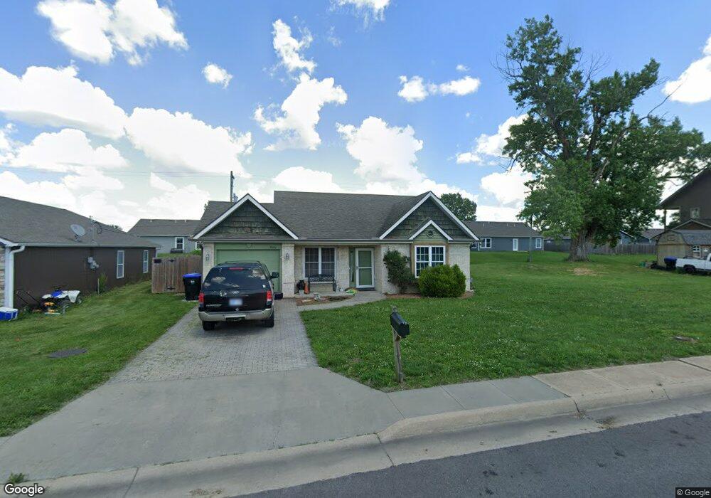
7040 SW Wheatfield Ln Topeka, KS 66619
Estimated Value: $160,000 - $196,000
3
Beds
2
Baths
1,158
Sq Ft
$149/Sq Ft
Est. Value
About This Home
This home is located at 7040 SW Wheatfield Ln, Topeka, KS 66619 and is currently estimated at $172,406, approximately $148 per square foot. 7040 SW Wheatfield Ln is a home located in Shawnee County with nearby schools including Pauline Central Primary School, Pauline South Intermediate School, and Washburn Rural Middle School.
Ownership History
Date
Name
Owned For
Owner Type
Purchase Details
Closed on
Feb 18, 2010
Sold by
Steel Robert and Steele Tiffany
Bought by
Stewart Kelly J
Current Estimated Value
Home Financials for this Owner
Home Financials are based on the most recent Mortgage that was taken out on this home.
Original Mortgage
$115,764
Outstanding Balance
$78,396
Interest Rate
5.5%
Mortgage Type
FHA
Estimated Equity
$94,010
Purchase Details
Closed on
Apr 9, 2009
Sold by
Lario Enterprises Llc
Bought by
Steel Robert
Home Financials for this Owner
Home Financials are based on the most recent Mortgage that was taken out on this home.
Original Mortgage
$86,775
Interest Rate
5.16%
Mortgage Type
Future Advance Clause Open End Mortgage
Create a Home Valuation Report for This Property
The Home Valuation Report is an in-depth analysis detailing your home's value as well as a comparison with similar homes in the area
Home Values in the Area
Average Home Value in this Area
Purchase History
| Date | Buyer | Sale Price | Title Company |
|---|---|---|---|
| Stewart Kelly J | -- | Capital Title Insurance Comp | |
| Steel Robert | -- | Heartlandtitle Services Inc |
Source: Public Records
Mortgage History
| Date | Status | Borrower | Loan Amount |
|---|---|---|---|
| Open | Stewart Kelly J | $115,764 | |
| Previous Owner | Steel Robert | $86,775 |
Source: Public Records
Tax History Compared to Growth
Tax History
| Year | Tax Paid | Tax Assessment Tax Assessment Total Assessment is a certain percentage of the fair market value that is determined by local assessors to be the total taxable value of land and additions on the property. | Land | Improvement |
|---|---|---|---|---|
| 2025 | $2,079 | $16,432 | -- | -- |
| 2023 | $2,079 | $14,219 | $0 | $0 |
| 2022 | $1,706 | $12,364 | $0 | $0 |
| 2021 | $1,500 | $11,039 | $0 | $0 |
| 2020 | $1,422 | $10,615 | $0 | $0 |
| 2019 | $1,381 | $10,306 | $0 | $0 |
| 2018 | $1,330 | $10,006 | $0 | $0 |
| 2017 | $1,354 | $10,006 | $0 | $0 |
| 2014 | $1,511 | $11,112 | $0 | $0 |
Source: Public Records
Map
Nearby Homes
- 7130 SW Lario Ln
- 0 SW Burlingame Rd
- 00 SW 85th St
- 6036 SE Adams St
- 4498 SW Moundview Dr
- XXXX SW Moundview Dr
- 5515 SW Mission Ave
- 3746 SW Topeka Blvd
- 224 SW Terra Dr
- 0 SE 77th St Unit 20821582
- 0 SE 77th St Unit 20417391
- 750 SE 93rd St
- 175 SE Willow Way St
- 154 SE Willow Way St Unit 154
- 156 SE Willow Way St Unit 156
- 5614 SW Fairlawn Rd
- 149 SE Willow Way St
- 113 SE Willow Way St
- 115 SE Willow Way St
- 226 SE 47th St Unit 226
- 7032 SW Wheatfield Ln
- 7102 SW Wheatfield Ln
- 7041 SW Greenview Dr
- 7024 SW Wheatfield Ln
- 7037 SW Greenview Dr
- 7045 SW Greenview Dr
- 7039 SW Wheatfield Ln
- 7033 SW Greenview Dr
- 7031 SW Wheatfield Ln
- 7018 SW Wheatfield Ln
- 7101 SW Greenview Dr
- 7101 SW Wheatfield Ln
- 7023 SW Wheatfield Ln
- 7029 SW Greenview Dr
- 7107 SW Greenview Dr
- 7016 SW Wheatfield Ln
- 7017 SW Wheatfield Ln
- Lot 15 SW Greenview Dr
- Lot 16 SW Greenview Dr
- 7107 SW Wheatfield Ln