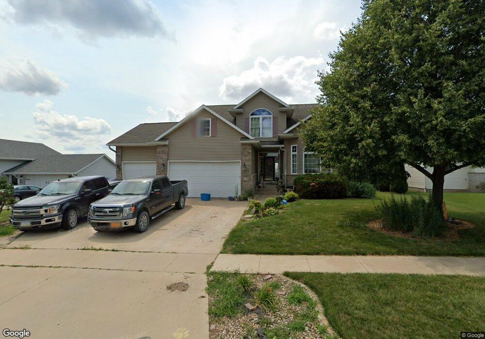
705 Boulder Dr Center Point, IA 52213
Estimated Value: $404,592 - $430,000
3
Beds
5
Baths
2,809
Sq Ft
$148/Sq Ft
Est. Value
About This Home
This home is located at 705 Boulder Dr, Center Point, IA 52213 and is currently estimated at $414,898, approximately $147 per square foot. 705 Boulder Dr is a home located in Linn County with nearby schools including Center Point-Urbana Primary School, Center Point-Urbana Intermediate School, and Center Point-Urbana Middle School.
Ownership History
Date
Name
Owned For
Owner Type
Purchase Details
Closed on
Sep 12, 2006
Sold by
Kohl Kevin D and Kohl Annette L
Bought by
Fuessley Blair C and Fuessley Wendy L
Current Estimated Value
Home Financials for this Owner
Home Financials are based on the most recent Mortgage that was taken out on this home.
Original Mortgage
$207,200
Outstanding Balance
$123,888
Interest Rate
6.59%
Mortgage Type
Purchase Money Mortgage
Estimated Equity
$291,010
Purchase Details
Closed on
Aug 11, 1999
Sold by
Thompson Paul H and Thompson Linda S
Bought by
Kohl Kevin D and Kohl Annette L
Home Financials for this Owner
Home Financials are based on the most recent Mortgage that was taken out on this home.
Original Mortgage
$211,500
Interest Rate
7.7%
Mortgage Type
Balloon
Purchase Details
Closed on
Mar 23, 1999
Sold by
Bsd Enterprises Inc
Bought by
Thompson Paul H
Home Financials for this Owner
Home Financials are based on the most recent Mortgage that was taken out on this home.
Original Mortgage
$184,000
Interest Rate
8%
Mortgage Type
Construction
Create a Home Valuation Report for This Property
The Home Valuation Report is an in-depth analysis detailing your home's value as well as a comparison with similar homes in the area
Home Values in the Area
Average Home Value in this Area
Purchase History
| Date | Buyer | Sale Price | Title Company |
|---|---|---|---|
| Fuessley Blair C | $258,500 | None Available | |
| Kohl Kevin D | $234,500 | -- | |
| Thompson Paul H | $18,500 | -- |
Source: Public Records
Mortgage History
| Date | Status | Borrower | Loan Amount |
|---|---|---|---|
| Open | Fuessley Blair C | $207,200 | |
| Previous Owner | Kohl Kevin D | $211,500 | |
| Previous Owner | Thompson Paul H | $184,000 |
Source: Public Records
Tax History Compared to Growth
Tax History
| Year | Tax Paid | Tax Assessment Tax Assessment Total Assessment is a certain percentage of the fair market value that is determined by local assessors to be the total taxable value of land and additions on the property. | Land | Improvement |
|---|---|---|---|---|
| 2025 | $7,490 | $450,500 | $29,500 | $421,000 |
| 2024 | $7,304 | $422,700 | $29,500 | $393,200 |
| 2023 | $7,304 | $422,700 | $29,500 | $393,200 |
| 2022 | $7,356 | $348,100 | $29,500 | $318,600 |
| 2021 | $6,888 | $351,200 | $29,500 | $321,700 |
| 2020 | $6,888 | $312,900 | $29,500 | $283,400 |
| 2019 | $5,642 | $264,400 | $29,500 | $234,900 |
| 2018 | $5,512 | $264,400 | $29,500 | $234,900 |
| 2017 | $5,472 | $255,000 | $29,500 | $225,500 |
| 2016 | $5,465 | $255,000 | $29,500 | $225,500 |
| 2015 | $5,471 | $255,000 | $29,500 | $225,500 |
| 2014 | $5,284 | $255,000 | $29,500 | $225,500 |
| 2013 | $5,246 | $255,000 | $29,500 | $225,500 |
Source: Public Records
Map
Nearby Homes
- 0 Palo Rd
- 523 E Terrace Dr
- 318 Crestview Dr
- 829 Main St S
- 529 Jefferson Ct
- 115 Main St
- 31 Acres N Center Point Rd
- 4299 Lewis Access Rd
- 0 Iowa St
- 0 Grain Ln
- 717 Pointer Cir
- 718 Pointer Cir
- 809 Iowa St
- 316 E Washington St
- 120 Green St
- 132 Green St
- 507 Maplewood Dr
- 702 Central Ave
- 508 Vine St
- 1120 Central Ave