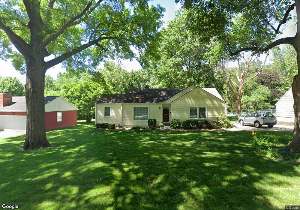
705 E Red Rd Independence, MO 64055
Hanthorn NeighborhoodEstimated Value: $181,189 - $300,000
2
Beds
2
Baths
1,151
Sq Ft
$201/Sq Ft
Est. Value
About This Home
This home is located at 705 E Red Rd, Independence, MO 64055 and is currently estimated at $231,297, approximately $200 per square foot. 705 E Red Rd is a home located in Jackson County with nearby schools including Sycamore Hills Elementary School, Bridger Middle School, and Pioneer Ridge Middle School.
Ownership History
Date
Name
Owned For
Owner Type
Purchase Details
Closed on
Jul 8, 2009
Sold by
Potter Sean E and Potter Mindy L
Bought by
Black Marcy L
Current Estimated Value
Purchase Details
Closed on
Apr 6, 2007
Sold by
Blake Thomas G and Blake Jacqueline C
Bought by
Potter Sean E
Purchase Details
Closed on
Feb 11, 2002
Sold by
Blake Jill E
Bought by
Blake Thomas G and Blake Jacqueline C
Home Financials for this Owner
Home Financials are based on the most recent Mortgage that was taken out on this home.
Original Mortgage
$104,000
Interest Rate
7.12%
Mortgage Type
Purchase Money Mortgage
Purchase Details
Closed on
Nov 21, 2000
Sold by
Prosser Eulan L
Bought by
Blake Jill E
Home Financials for this Owner
Home Financials are based on the most recent Mortgage that was taken out on this home.
Original Mortgage
$67,900
Interest Rate
7.82%
Mortgage Type
Purchase Money Mortgage
Create a Home Valuation Report for This Property
The Home Valuation Report is an in-depth analysis detailing your home's value as well as a comparison with similar homes in the area
Home Values in the Area
Average Home Value in this Area
Purchase History
| Date | Buyer | Sale Price | Title Company |
|---|---|---|---|
| Black Marcy L | -- | Chicago Title | |
| Potter Sean E | -- | None Available | |
| Blake Thomas G | -- | Stewart Title | |
| Blake Jill E | -- | Heart Of America Title Inc |
Source: Public Records
Mortgage History
| Date | Status | Borrower | Loan Amount |
|---|---|---|---|
| Previous Owner | Blake Thomas G | $104,000 | |
| Previous Owner | Blake Jill E | $67,900 |
Source: Public Records
Tax History
| Year | Tax Paid | Tax Assessment Tax Assessment Total Assessment is a certain percentage of the fair market value that is determined by local assessors to be the total taxable value of land and additions on the property. | Land | Improvement |
|---|---|---|---|---|
| 2025 | $1,935 | $24,875 | $5,514 | $19,361 |
| 2024 | $1,891 | $27,928 | $5,024 | $22,904 |
| 2023 | $1,891 | $27,928 | $4,431 | $23,497 |
| 2022 | $1,389 | $18,810 | $5,168 | $13,642 |
| 2021 | $1,389 | $18,810 | $5,168 | $13,642 |
| 2020 | $1,428 | $18,790 | $5,168 | $13,622 |
| 2019 | $1,405 | $18,790 | $5,168 | $13,622 |
| 2018 | $784,562 | $17,444 | $3,401 | $14,043 |
| 2017 | $1,366 | $17,444 | $3,401 | $14,043 |
| 2016 | $1,345 | $17,007 | $3,914 | $13,093 |
Source: Public Records
Map
Nearby Homes
- 660 E Red Rd
- 921 E Manor Rd
- 718 E Gudgell Ave
- 735 E Devon St
- 1954 S Lake Terrace
- 212 E Hansen Ct Unit 1
- 303 E Partridge Ave Unit 39
- 301 E Partridge Ave Unit K
- 421 E Angus St
- 1340 S Emery Ave
- 603 E Myrtle St
- 1339 S Hocker Ave
- 14600 E 33rd St S
- 1402 S Dodgion Ave
- 2800 S Woodbury Dr
- 1312 S Pearl St
- 1815 & 1719 S Osage St
- 14816 E 33rd St S
- 2724 S Woodbury Dr
- 2705 S Haden Ct
Your Personal Tour Guide
Ask me questions while you tour the home.