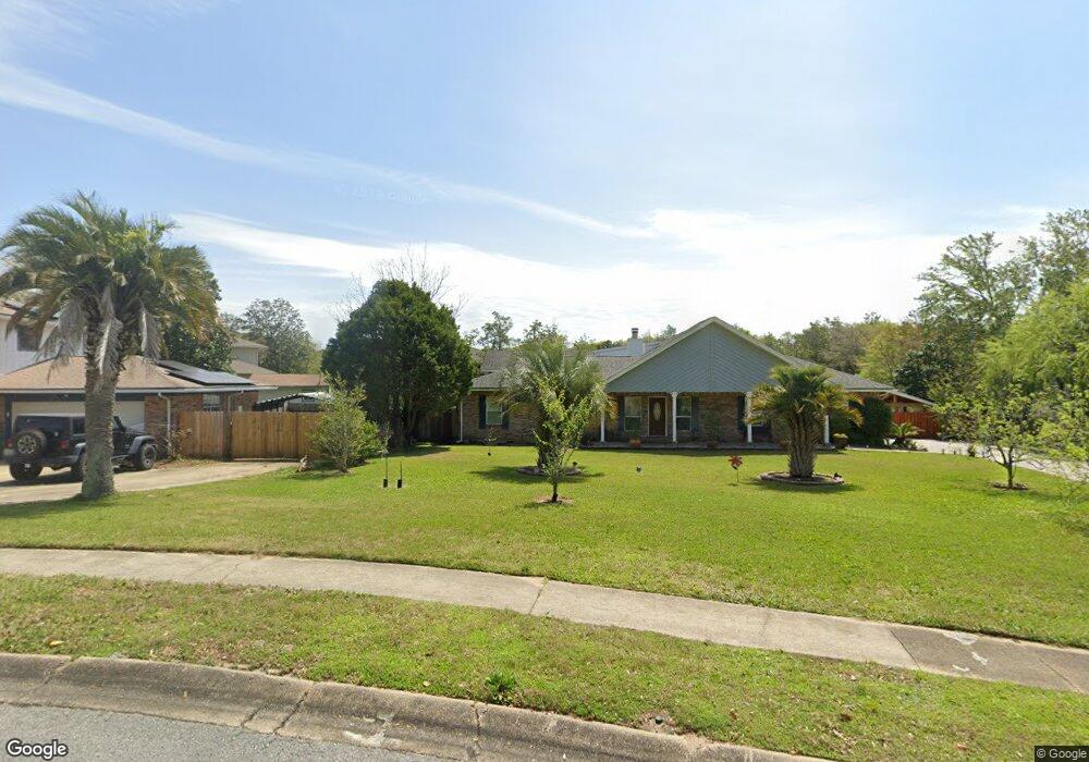
705 Overbrook Dr Fort Walton Beach, FL 32547
Wright NeighborhoodEstimated Value: $501,000 - $603,000
4
Beds
3
Baths
3,056
Sq Ft
$185/Sq Ft
Est. Value
About This Home
This home is located at 705 Overbrook Dr, Fort Walton Beach, FL 32547 and is currently estimated at $564,510, approximately $184 per square foot. 705 Overbrook Dr is a home located in Okaloosa County with nearby schools including Wright Elementary School, Max Bruner Junior Middle School, and Fort Walton Beach High School.
Ownership History
Date
Name
Owned For
Owner Type
Purchase Details
Closed on
May 31, 2002
Sold by
Hillyer John C and Hillyer Rosemary
Bought by
Findley Jerry E
Current Estimated Value
Home Financials for this Owner
Home Financials are based on the most recent Mortgage that was taken out on this home.
Original Mortgage
$124,000
Outstanding Balance
$52,578
Interest Rate
6.85%
Estimated Equity
$511,932
Create a Home Valuation Report for This Property
The Home Valuation Report is an in-depth analysis detailing your home's value as well as a comparison with similar homes in the area
Home Values in the Area
Average Home Value in this Area
Purchase History
| Date | Buyer | Sale Price | Title Company |
|---|---|---|---|
| Findley Jerry E | $155,000 | Touchstone Land Title Inc |
Source: Public Records
Mortgage History
| Date | Status | Borrower | Loan Amount |
|---|---|---|---|
| Open | Findley Jerry E | $124,000 |
Source: Public Records
Tax History Compared to Growth
Tax History
| Year | Tax Paid | Tax Assessment Tax Assessment Total Assessment is a certain percentage of the fair market value that is determined by local assessors to be the total taxable value of land and additions on the property. | Land | Improvement |
|---|---|---|---|---|
| 2024 | $4,773 | $437,229 | -- | -- |
| 2023 | $4,773 | $424,494 | $0 | $0 |
| 2022 | $5,187 | $415,450 | $87,556 | $327,894 |
| 2021 | $2,563 | $237,843 | $0 | $0 |
| 2020 | $2,440 | $226,855 | $0 | $0 |
| 2019 | $2,408 | $221,755 | $0 | $0 |
| 2018 | $2,384 | $217,620 | $0 | $0 |
| 2017 | $2,340 | $213,144 | $0 | $0 |
| 2016 | $2,277 | $208,760 | $0 | $0 |
| 2015 | $2,819 | $209,663 | $0 | $0 |
| 2014 | $2,701 | $200,684 | $0 | $0 |
Source: Public Records
Map
Nearby Homes
- 510 Sioux Cir
- 403 Cheyenne Cir
- 609 Audubon Dr
- 333 Jonquil Cir
- 205 Pine St
- 214 Pine St
- 105 Lincoln Dr NW
- 19 Forest Grove Place
- 310 Jonquil Ave NW
- 210 Pelham Rd Unit 215A
- 210 Pelham Rd Unit B107
- 210 Pelham Rd Unit 107C
- 210 Pelham Rd Unit 109B
- 210 Pelham Rd Unit 111C
- 210 Pelham Rd Unit 111B
- 210 Pelham Rd Unit 205B
- 210 Pelham Rd Unit 104B
- 210 Pelham Rd Unit 214A
- 510 Vermont Ave
- 649 Overbrook Dr
- 707 Overbrook Dr
- 703 Overbrook Dr
- 203 Manring Dr
- 205 Manring Dr
- 709 Overbrook Dr
- 207 Manring Dr
- 701 Overbrook Dr
- 704 Overbrook Dr
- 201 Pawnee Cir
- 201 Manring Dr
- 711 Overbrook Dr
- 702 Overbrook Dr
- 175 Manring Dr
- 138 Woodbine Cir
- 203 Pawnee Cir
- 139 Woodbine Cir
- 1851 Norwood Ct Unit 6
- 1851 Norwood Ct Unit 3
- 1851 Norwood Ct Unit 5
- 1851 Norwood Ct Unit 4