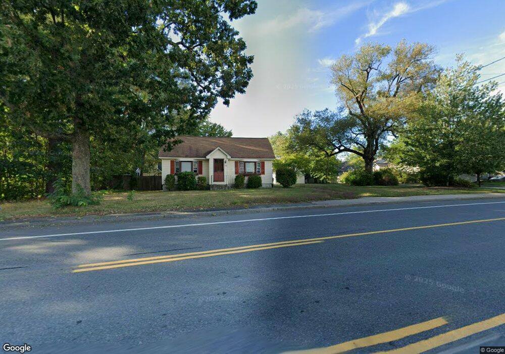
705 W Hollis St Nashua, NH 03062
West Hollis NeighborhoodEstimated Value: $428,590 - $565,000
2
Beds
1
Bath
1,056
Sq Ft
$448/Sq Ft
Est. Value
About This Home
This home is located at 705 W Hollis St, Nashua, NH 03062 and is currently estimated at $473,398, approximately $448 per square foot. 705 W Hollis St is a home located in Hillsborough County with nearby schools including Ledge Street Elementary School, Elm Street Middle School, and Nashua High School South.
Ownership History
Date
Name
Owned For
Owner Type
Purchase Details
Closed on
Aug 12, 2020
Sold by
Graves Jade O
Bought by
Henry Courtney S
Current Estimated Value
Purchase Details
Closed on
Jan 29, 2008
Sold by
Lowther Place Llc
Bought by
Chan Tom and Chan Rosa
Purchase Details
Closed on
Oct 17, 2006
Sold by
Stancik Carl G
Bought by
Lowther Place Llc
Home Financials for this Owner
Home Financials are based on the most recent Mortgage that was taken out on this home.
Original Mortgage
$1,120,350
Interest Rate
6.47%
Mortgage Type
Purchase Money Mortgage
Create a Home Valuation Report for This Property
The Home Valuation Report is an in-depth analysis detailing your home's value as well as a comparison with similar homes in the area
Home Values in the Area
Average Home Value in this Area
Purchase History
| Date | Buyer | Sale Price | Title Company |
|---|---|---|---|
| Henry Courtney S | $400,000 | None Available | |
| Chan Tom | $369,900 | -- | |
| Lowther Place Llc | $643,900 | -- |
Source: Public Records
Mortgage History
| Date | Status | Borrower | Loan Amount |
|---|---|---|---|
| Previous Owner | Lowther Place Llc | $1,020,600 | |
| Previous Owner | Lowther Place Llc | $1,120,350 |
Source: Public Records
Tax History Compared to Growth
Tax History
| Year | Tax Paid | Tax Assessment Tax Assessment Total Assessment is a certain percentage of the fair market value that is determined by local assessors to be the total taxable value of land and additions on the property. | Land | Improvement |
|---|---|---|---|---|
| 2024 | $6,034 | $379,500 | $162,000 | $217,500 |
| 2023 | $5,733 | $314,500 | $129,600 | $184,900 |
| 2022 | $5,683 | $314,500 | $129,600 | $184,900 |
| 2021 | $4,906 | $211,300 | $86,400 | $124,900 |
| 2020 | $4,777 | $211,300 | $86,400 | $124,900 |
| 2019 | $4,598 | $211,300 | $86,400 | $124,900 |
| 2018 | $4,482 | $211,300 | $86,400 | $124,900 |
| 2017 | $4,044 | $156,800 | $74,500 | $82,300 |
| 2016 | $3,931 | $156,800 | $74,500 | $82,300 |
| 2015 | $3,846 | $156,800 | $74,500 | $82,300 |
| 2014 | $3,771 | $156,800 | $74,500 | $82,300 |
Source: Public Records
Map
Nearby Homes
- 46 Scenic Dr
- 40 Spring Cove Rd Unit U117
- 31 Spring Cove Rd Unit U148
- 12 Spring Cove Rd Unit U103
- 500 Candlewood Park Unit 21
- 20 Martha St
- 599 W Hollis St
- 11 Bartemus Trail Unit 204
- 47 Dogwood Dr Unit U202
- 27 Country Hill Rd Unit U90
- 4 Chesapeake Rd
- 76 Bartemus Trail Unit U231
- 28 Bartemus Trail Unit U210
- 4 Nelson St
- 5 Mark St
- 5 Cheryl St
- 3 Richmond St
- 8 Althea Ln Unit U26
- 25 Cortez Dr Unit U57
- 5 Meghan Dr Unit U23
- 1 Norma Dr
- 2 Lowther Place Unit U3
- 699 W Hollis St
- 699-701 W Hollis St
- 699-701 W Hollis St Unit 30
- 699-701 W Hollis St Unit 29
- 699-701 W Hollis St Unit 27
- 699-701 W Hollis St Unit 26
- 699-701 W Hollis St Unit 23
- 699-701 W Hollis St Unit 22
- 699-701 W Hollis St Unit 21
- 699-701 W Hollis St Unit 20
- 699-701 W Hollis St Unit 19
- 699-701 W Hollis St Unit 18
- 699-701 W Hollis St Unit 17
- 699-701 W Hollis St Unit 16
- 699-701 W Hollis St Unit 15
- 699-701 W Hollis St Unit 13
- 50 Seneca Dr Unit 23
- 4 Scenic Dr Unit 1