
Seller's Agent in 2026
Lacie Sibley
Boutique Real Estate
(515) 669-9430
1 in this area
118 Total Sales


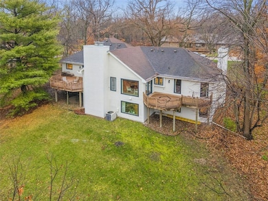


Luxury & convenience in a beautifully remodeled ranch W/O, more than 4,800 sq ft, on nearly an acre in a peaceful, tree-filled Johnston neighborhood. Surrounded by timber & wildlife, this home offers the rare feel of country living just minutes from town. Step inside to gorgeous wood floors, luxurious carpet, & fully renovated interior designed for comfort & style. Open kit w/granite counters, pull-out cabinetry, gas cooktop, & eat-in dining w/breathtaking backyard views. A cozy liv rm offers a wood-burning fireplace & access to 1 of 2 composite decks, perfect for morning coffee. A spacious formal dining rm (or add'l liv rm) adds versatility & features another charming fireplace. You’ll love the den w/floor-to-ceiling built-ins—ideal for work or relaxation. The primary suite is a retreat, w/private deck, & spa-like en suite boasts a soaking tub, tiled shower, dual vanities w/linen, & generous walk-in closet. BR #2 is spacious w/extra lrg closet, adorable wall murals, plus a convenient 3/4 BA w/enormous walk-in shower & dual heads across the hall. Just off the 2-car gar is a half BA w/laundry. Fully fin LL expands living space w/2 lrg BRs, plus a bonus room perfect for 5th BR, office, gym, or hobby space. Enjoy the liv rm w/3rd fireplace, sit-up bar w/impressive storage, & kitchenette w/full-sz fridge & stove. A full BA & add’l under-stair storage completes this level. Situated on a quiet, 1-way-in/1-way-out street, this neighborhood clearly shows pride in ownership.
We collect this data history from publicly available records. To have your information removed, we recommend requesting removal directly through your county’s website.
| Date | Type | Sale Price | Title Company |
|---|---|---|---|
| Warranty Deed | $725,000 | None Listed On Document | |
| Warranty Deed | $342,500 | None Available | |
| Legal Action Court Order | -- | None Available | |
| Warranty Deed | $169,500 | None Available |
We collect this data history from publicly available records. To have your information removed, we recommend requesting removal directly through your county’s website.
| Date | Status | Loan Amount | Loan Type |
|---|---|---|---|
| Open | $543,750 | New Conventional | |
| Previous Owner | $274,000 | New Conventional | |
| Previous Owner | $70,000 | Seller Take Back |
| Date | Event | Price | List to Sale | Price per Sq Ft |
|---|---|---|---|---|
| 03/05/2026 03/05/26 | Sold | $725,000 | -8.2% | $297 / Sq Ft |
| 02/06/2026 02/06/26 | Pending | -- | -- | -- |
| 01/12/2026 01/12/26 | Price Changed | $789,900 | -4.2% | $324 / Sq Ft |
| 11/26/2025 11/26/25 | For Sale | $824,900 | -- | $338 / Sq Ft |
| Year | Tax Paid | Tax Assessment Tax Assessment Total Assessment is a certain percentage of the fair market value that is determined by local assessors to be the total taxable value of land and additions on the property. | Land | Improvement |
|---|---|---|---|---|
| 2025 | $7,760 | $504,200 | $109,100 | $395,100 |
| 2024 | $7,760 | $473,200 | $101,000 | $372,200 |
| 2023 | $7,648 | $473,200 | $101,000 | $372,200 |
| 2022 | $8,544 | $410,000 | $91,000 | $319,000 |
| 2021 | $8,408 | $410,000 | $91,000 | $319,000 |
| 2020 | $8,266 | $384,500 | $85,000 | $299,500 |
| 2019 | $8,160 | $384,500 | $85,000 | $299,500 |
| 2018 | $7,948 | $352,400 | $76,400 | $276,000 |
| 2017 | $7,666 | $352,400 | $76,400 | $276,000 |
| 2016 | $7,500 | $333,600 | $71,200 | $262,400 |
| 2015 | $7,500 | $333,600 | $71,200 | $262,400 |
| 2014 | $7,966 | $349,100 | $73,500 | $275,600 |
Seller's Agent in 2026
Lacie Sibley
Boutique Real Estate
(515) 669-9430
1 in this area
118 Total Sales
Buyer's Agent in 2026
Kari Stone
RE/MAX
(515) 402-7066
1 in this area
47 Total Sales
Source: Des Moines Area Association of REALTORS®
MLS Number: 730976
APN: 241-01020025000
Disclaimer: Certain information contained herein is derived from information provided by parties other than Homes.com. All information provided is deemed reliable, but is not guaranteed to be accurate and should be independently verified.
![]() IDX information is provided exclusively for personal, non-commercial use, and may not be used for any purpose other than to identify prospective properties consumers may be interested in purchasing. Information is deemed reliable but not guaranteed.
IDX information is provided exclusively for personal, non-commercial use, and may not be used for any purpose other than to identify prospective properties consumers may be interested in purchasing. Information is deemed reliable but not guaranteed.
Ask me questions while you tour the home.