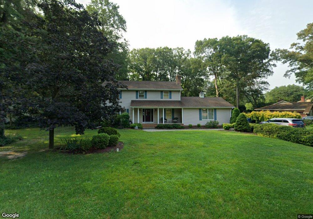
7063 Atlanta Cir Seaford, DE 19973
Estimated Value: $307,000 - $391,000
3
Beds
--
Bath
2,240
Sq Ft
$158/Sq Ft
Est. Value
About This Home
This home is located at 7063 Atlanta Cir, Seaford, DE 19973 and is currently estimated at $354,724, approximately $158 per square foot. 7063 Atlanta Cir is a home located in Sussex County with nearby schools including Seaford Central Elementary School, Frederick Douglass Elementary School, and Seaford Middle School.
Ownership History
Date
Name
Owned For
Owner Type
Purchase Details
Closed on
Sep 6, 2023
Sold by
Moynihan Laurence P and Moynihan Kaye P
Bought by
Sauveur Raymond and Sauveur Stephanie N
Current Estimated Value
Home Financials for this Owner
Home Financials are based on the most recent Mortgage that was taken out on this home.
Original Mortgage
$323,160
Outstanding Balance
$295,134
Interest Rate
6.11%
Mortgage Type
Seller Take Back
Estimated Equity
$59,590
Purchase Details
Closed on
Jul 27, 1987
Bought by
Moynihan Laurence P and Moynihan Kaye P
Create a Home Valuation Report for This Property
The Home Valuation Report is an in-depth analysis detailing your home's value as well as a comparison with similar homes in the area
Home Values in the Area
Average Home Value in this Area
Purchase History
| Date | Buyer | Sale Price | Title Company |
|---|---|---|---|
| Sauveur Raymond | $315,000 | None Listed On Document | |
| Moynihan Laurence P | $19,000 | -- |
Source: Public Records
Mortgage History
| Date | Status | Borrower | Loan Amount |
|---|---|---|---|
| Open | Sauveur Raymond | $323,160 |
Source: Public Records
Tax History Compared to Growth
Tax History
| Year | Tax Paid | Tax Assessment Tax Assessment Total Assessment is a certain percentage of the fair market value that is determined by local assessors to be the total taxable value of land and additions on the property. | Land | Improvement |
|---|---|---|---|---|
| 2025 | $1,259 | $26,200 | $2,500 | $23,700 |
| 2024 | $1,344 | $26,200 | $2,500 | $23,700 |
| 2023 | $850 | $26,200 | $2,500 | $23,700 |
| 2022 | $813 | $26,200 | $2,500 | $23,700 |
| 2021 | $916 | $26,200 | $2,500 | $23,700 |
| 2020 | $1,032 | $26,200 | $2,500 | $23,700 |
| 2019 | $848 | $26,200 | $2,500 | $23,700 |
| 2018 | $818 | $26,200 | $0 | $0 |
| 2017 | $757 | $26,200 | $0 | $0 |
| 2016 | $678 | $26,200 | $0 | $0 |
| 2015 | $677 | $26,200 | $0 | $0 |
| 2014 | $1,059 | $26,200 | $0 | $0 |
Source: Public Records
Map
Nearby Homes
- 6873 Robin Dr
- 6998 Atlanta Cir
- 1403 Tomlinson Dr
- 1102 Wythe Ln
- 23075 Atlanta Rd
- 413 Plantation Dr
- 312 Plantation Dr
- Fairfield Slab Plan at Belle Ayre
- Pembroke Slab Plan at Belle Ayre
- Princeton Slab Plan at Belle Ayre
- Charleston Slab Plan at Belle Ayre
- Hanover Slab Plan at Belle Ayre
- 22502 Atlanta Rd
- 1123 Magnolia Dr
- 501 Chatham Dr
- 131 Belle Ayre Dr
- 0 Helens Ln
- 23849 Ross Station Rd
- 732A Hurley Park Dr
- 714 W Ivy Dr
- 7053 Atlanta Cir
- 7081 Atlanta Cir
- 6861 Robin Dr
- 6861 Robin Dr
- 7064 Atlanta Cir
- 7041 Atlanta Cir
- 7050 Atlanta Cir
- 7050 Atlanta Cir
- 7091 Atlanta Cir
- 7091 Atlanta Cir
- 6847 Robin Dr
- 7076 Atlanta Cir
- 7088 Atlanta Cir
- 7038 Atlanta Cir
- 7101 Atlanta Cir
- 0 Atlanta Cir Unit 1001064816
- 0 Atlanta Cir Unit 1001160096
- 0 Atlanta Cir Unit 102 1001011704
- 0 Atlanta Cir Unit 51 1001074172
- 917 N Atlanta Cir