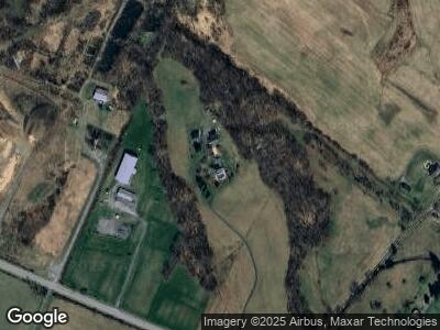
7069 Lily Pons Rd Adamstown, MD 21710
Estimated Value: $616,000 - $1,910,259
--
Bed
3
Baths
4,425
Sq Ft
$254/Sq Ft
Est. Value
About This Home
This home is located at 7069 Lily Pons Rd, Adamstown, MD 21710 and is currently estimated at $1,124,086, approximately $254 per square foot. 7069 Lily Pons Rd is a home located in Frederick County with nearby schools including Urbana Elementary School, Urbana Middle School, and Urbana High School.
Ownership History
Date
Name
Owned For
Owner Type
Purchase Details
Closed on
Jan 8, 2019
Sold by
Chaconas Peter George
Bought by
Chaconas Peter G and Chaconas Katharine A
Current Estimated Value
Purchase Details
Closed on
Jan 18, 1985
Sold by
Cosgrove Perry C
Bought by
Chaconas Peter George
Home Financials for this Owner
Home Financials are based on the most recent Mortgage that was taken out on this home.
Original Mortgage
$63,000
Interest Rate
13.12%
Create a Home Valuation Report for This Property
The Home Valuation Report is an in-depth analysis detailing your home's value as well as a comparison with similar homes in the area
Home Values in the Area
Average Home Value in this Area
Purchase History
| Date | Buyer | Sale Price | Title Company |
|---|---|---|---|
| Chaconas Peter G | -- | None Available | |
| Chaconas Peter George | $90,000 | -- |
Source: Public Records
Mortgage History
| Date | Status | Borrower | Loan Amount |
|---|---|---|---|
| Closed | Chaconas Peter George | $63,000 |
Source: Public Records
Tax History Compared to Growth
Tax History
| Year | Tax Paid | Tax Assessment Tax Assessment Total Assessment is a certain percentage of the fair market value that is determined by local assessors to be the total taxable value of land and additions on the property. | Land | Improvement |
|---|---|---|---|---|
| 2024 | $12,864 | $1,121,300 | $226,700 | $894,600 |
| 2023 | $11,787 | $1,067,867 | $0 | $0 |
| 2022 | $11,113 | $1,014,433 | $0 | $0 |
| 2021 | $10,088 | $961,000 | $189,200 | $771,800 |
| 2020 | $10,088 | $921,567 | $0 | $0 |
| 2019 | $9,630 | $882,133 | $0 | $0 |
| 2018 | $9,363 | $842,700 | $182,900 | $659,800 |
| 2017 | $8,965 | $842,700 | $0 | $0 |
| 2016 | $7,653 | $751,167 | $0 | $0 |
| 2015 | $7,653 | $705,400 | $0 | $0 |
| 2014 | $7,653 | $699,633 | $0 | $0 |
Source: Public Records
Map
Nearby Homes
- 2994 Hope Mills Ln
- 3107 Flint Hill Rd
- 5810 Underwood Ct
- 7119 Michaels Mill Rd
- 5880 Union Ridge Dr
- 2833 Roderick Rd
- 2718 Laura Dr
- 6822 Buckingham Ln
- 2703 Longfield Place
- 3447 Buckeystown Pike
- 2824 Haddington Ct
- 5690 Mountville Rd
- 5900 Union Ridge Dr
- 0 Michaels Mill Rd
- 8408 Sandia Ct
- 2726 Coffee Way
- 6779 Keller Lime Plant Rd
- 5522 Young Family Trail W
- 0002 Carnival Ln
- 0004 Carnival Ln
- 7069 Lily Pons Rd
- 7000 Lily Pons Rd
- 2190 Park Mills Rd
- 7106 Ira Sears Rd
- 2027 Park Mills Rd
- 2027 Park Mills Rd
- 2210 Park Mills Rd
- 7001 Lily Pons Rd
- 7001 Lily Pons Rd
- 2214 Park Mills Rd
- 1904 Park Mills Rd
- 0 Stewart Hill Rd Unit 1003289989
- 0 Stewart Hill Rd Unit FR10089357
- 0 Stewart Hill Rd Unit MDFR2033528
- 0 Stewart Hill Rd Unit MDFR2006394
- 1899 Park Mills Rd
- 1921 Park Mills Rd
- 0 Park Mills Rd Unit FR10071663
- 0 Park Mills Rd Unit FR7894682
- 2229 Park Mills Rd
